All Activity
- Past hour
-
He is the most conservative met i have ever seen. He is always playing catch up. I would sooner trust Justin Berk, at least he has faith in the flakes.
-
Upton has “rain/snow” in its forecast for northern half of Long Island tomorrow night
-
How could she cheat on such a stud. I’m appalled.
-
Mammoth is blizzarding at 21 20 degrees with wind gusts to 45. Village level has 3-4 inches. Main Lodge level has 8-9 inches on the ground with 21 degrees and it is coming down and blowing all over the place! McCoy Station at 9600 feet has 12-14 inches with 18 degrees, Summit at 11000 feet has 20 inches of snow at 14 degrees. Snow all night, at least another 4 inches, then more snow on Thursday from yet another storm in the Pacific Set. https://www.mammothmountain.com/on-the-mountain/mammoth-webcam/main-lodge https://www.mammothmountain.com/on-the-mountain/mammoth-webcam/woolly-cam Mammoth is set to Open on Nov 20.
- Today
-

November 2025 general discussions and probable topic derailings ...
mreaves replied to Typhoon Tip's topic in New England
It’s even reaching here. Maybe half an inch tonight. -
 The 4 Seasons changed their profile photo
 -

November 2025 general discussions and probable topic derailings ...
powderfreak replied to Typhoon Tip's topic in New England
24-36 hours later and still going.
-
Just investigated and it is indeed crisp out there lol
-
From JB today: Euro MJO closest analogs 1983 and 1989 The severe cold Decembers of 1983 and 1989 both raise the spectre of a cold shot letting loose into the Texas Citrus areas, with Fla secondary concern had a major stratwarm in mid to late November, almost identical to now —————- The only problem with this is that there was no major stratwarm in mid to late Nov of 1983 or 1989 or anytime during early to mid winter for both for that matter: https://www.researchgate.net/figure/The-SSW-and-SFW-event-onset-date-year-and-type-identified-in-the-NCEP-NCAR-dataset-The_tbl1_267063738 ———- Also, I checked to see if the 60-90N temperatures in the strat. in mid to late Nov were notably warm and they weren’t. Lastly, I checked the zonal winds at 60N in both Novs to see if they were weak despite no actual reversal. They weren’t as they were pretty close to normal. https://acd-ext.gsfc.nasa.gov/Data_services/met/ann_data.html#ncep_clim_stats_nh
-
Already down to 37 this evening
-
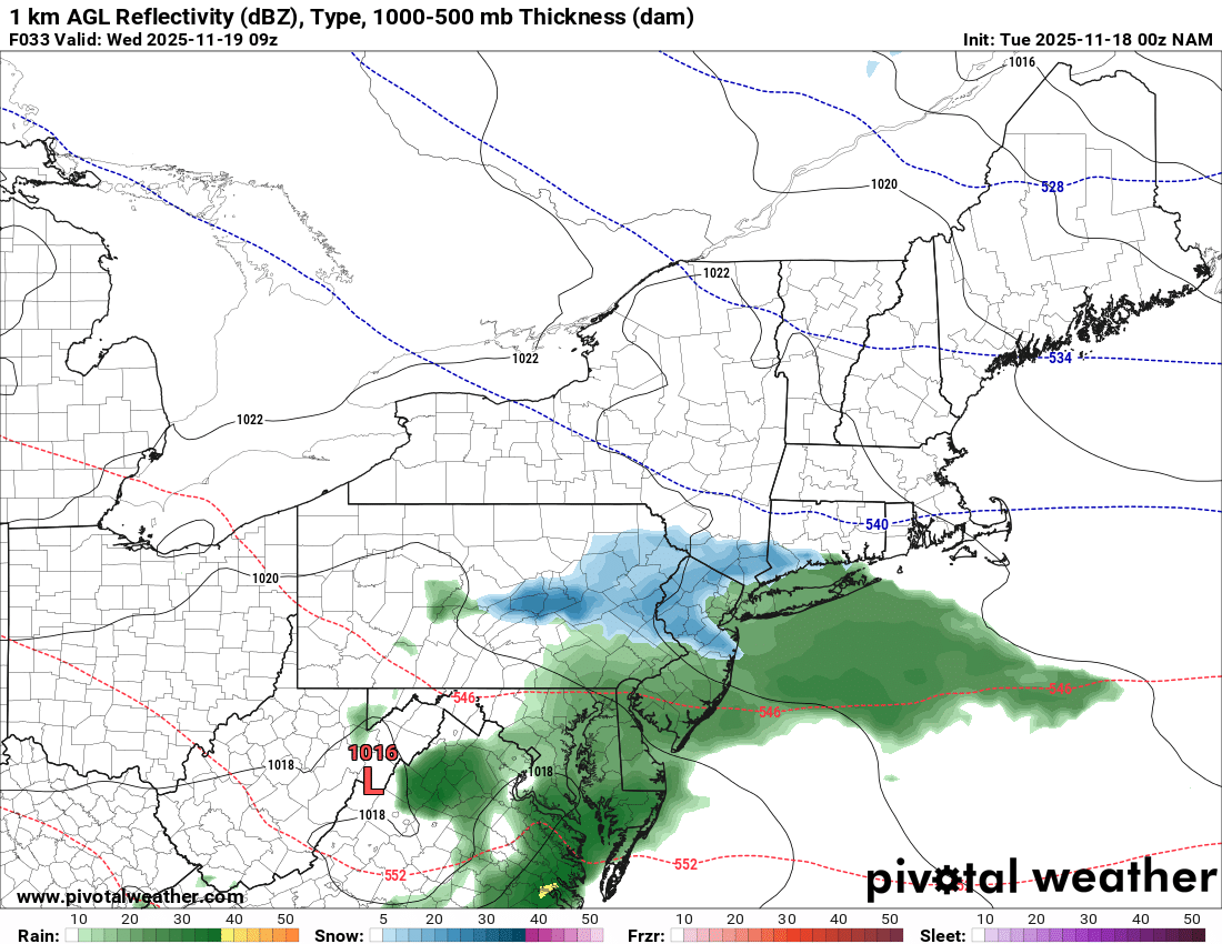
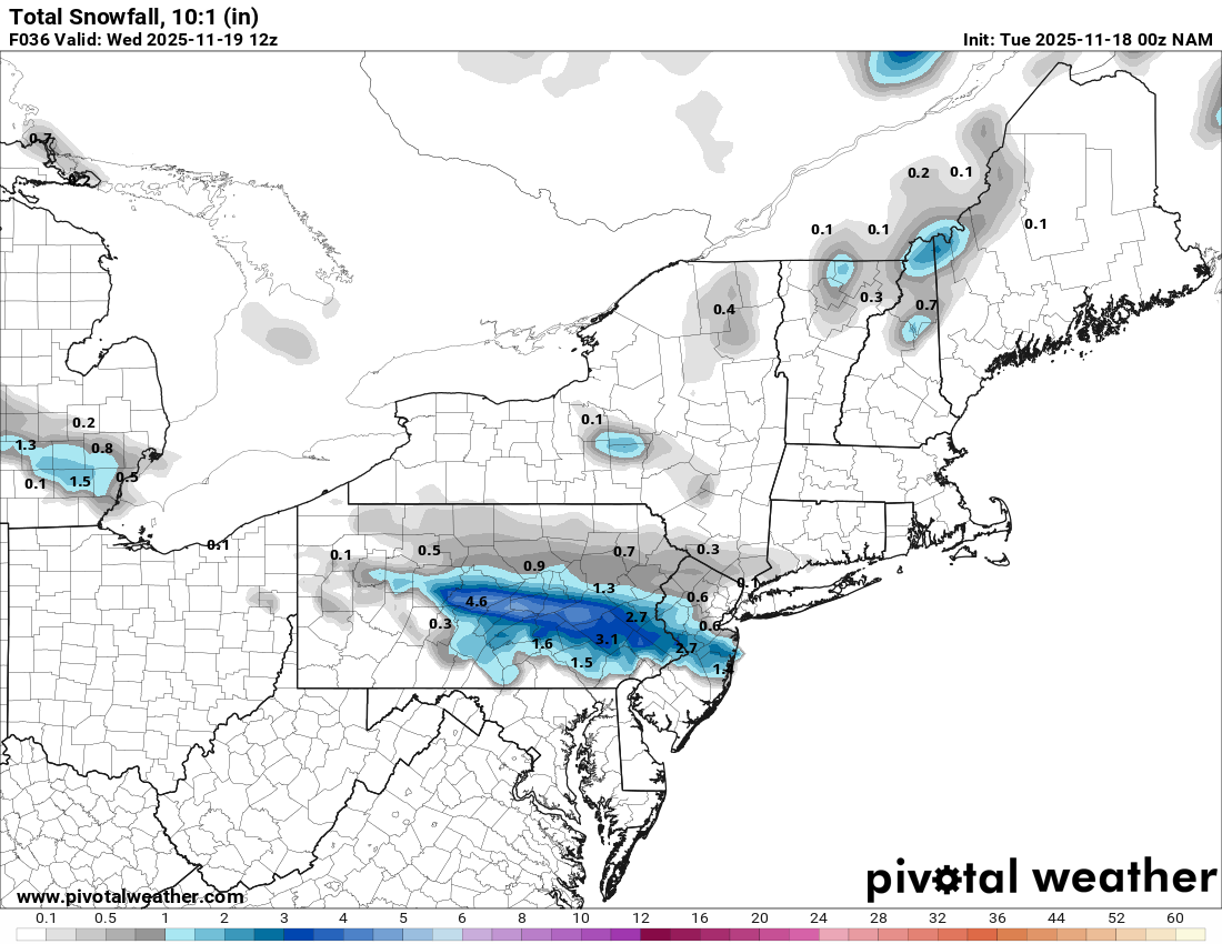
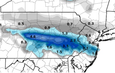
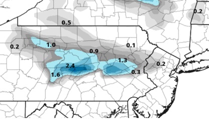
Just about every 0z model shows some snow or rain/snow mix for parts of EPA through Warren, Sussex, and Morris counties in NJ overnight Tuesday into Wednesday. It's mostly a narrow strip at the northern edge of a decaying precipitation shield, but a few models mix in some snow across a wider area. It's an overnight deal that most won't even notice and it's certainly not a sexy storm. The other problem is surface temperatures in the mid-30s. But I believe there's a chance for an inch or two of snow in a few spots above 1000ft along the northern edge of the steady light precipitation. That's more likely to occur in CPA, but if it holds together long enough, parts of NJ might be in play. The NAM looks overdone but RGEM/GFS/ECM/ICON look plausible. Note the images show 10:1 snow accumulation even though actual accumulations are unlikely in lower elevations due to surface temperatures. 0z NAM 0z RGEM
-

2025-2026 New England Snow Recordkeeping Thread
bristolri_wx replied to bristolri_wx's topic in New England
@Lava Rock all set check your PM. -
Just got home for the day, was 28 degrees down at the river on car thermometer, 37.4 here at the house 1/3 mile away and 300 foot higher in elevation.
-
2025-2026 New England Snow Recordkeeping Thread
bristolri_wx replied to bristolri_wx's topic in New England
@MarkO all set. Check PM for form link. -
30 here now. Maybe upper 20s?
-
44" seasonal snowfall measured. 38" of snow depth at the Stake. Not much settling happening out there. This snow is dense, with plenty of dense graupel and smaller flakes, mixed with wind. It has felt like dense sand... QPF-rich frozen precip.
-
I think a harsh reality for all of us each winter is that the weather we were pre-conditioned on throughout Dec, Jan and Feb many years ago has now shifted 2-3 states north for all of the reasons you’ve listed. I’ve lived in the foothills my whole life and we haven’t had a true NC foothills winter that I grew up on in a very long time. It resembles how I would’ve viewed a Georgia winter as a kid. Likewise, for folks in SC and Georgia, they’re really leaning on the side of infrequency. The woes go further north too. That NC foothills winter near and dear to my heart is the new reality for areas like DC and Baltimore. It’s all built into perspective and I myself struggle adjusting to that. I guess it makes all snowfall that much more special in the future.
-
Snow totals from the storm. https://www.qsl.net/n2sln/stormtot25122002.html
-
 One of the early 90s great winters came close to wire to wire. Every time it warmed up it was brief with a cold front with squalls ending it. Will probably remembers the year, I want to say 93-94.
 -
The resemblance to last year is uncanny, the torches are getting rug pulled. Remember when it was supposed approach 70 yesterday?
-
Imagine tomorrow night's system but with the same level of cold anomaly compared to December's or January's average.
-

Central PA Fall Discussions and Obs
MJO812 replied to ChescoWx's topic in Upstate New York/Pennsylvania
Nam anyone ?

-

Major Hurricane Melissa - 892mb - 185mph Jamaica landfall
yotaman replied to GaWx's topic in Tropical Headquarters
I saw Josh's post on Facebook. He got into the inner eyewall of Melissa with a lowest pressure of 927 mb. He has a detailed analysis of it if you wish to read it. The storm slacked just enough to claim he hit the edge of the eye. -
28.6 currently
-

November 2025 general discussions and probable topic derailings ...
ORH_wxman replied to Typhoon Tip's topic in New England
This is really hard to measure so hard to say the magnitude of the impact. It probably played some role. It was hard to really amplify ridges over the Rockies last winter. I’m sure there was a level of poor “luck” involved too in the sub-synoptic wavelengths. -
I think we got 8-9” out in Suffolk. That backend really blew up and crushed us. I was driving to and from JFK and saw the rain/snow line.