All Activity
- Past hour
-
I wonder if I will ever get a travel baseball game in this fall... As of right now, it looks like Sunday is another washout.
-

October Comes Early: Late September Multi-Hazard Hybrid Storm
Ginx snewx replied to WxWatcher007's topic in New England
3.14 pretty much exactly as Euro had -

October Comes Early: Late September Multi-Hazard Hybrid Storm
ineedsnow replied to WxWatcher007's topic in New England
off to Hampton beach to see high tide come in.. I know there wont be much flooding but maybe walk the beach after and find something neat.. -
Were going downhill fast in the temperature department.
-

Central PA Autumn 2026
Mount Joy Snowman replied to canderson's topic in Upstate New York/Pennsylvania
Low of 59 and a two-day rainfall total of .76”. Mondays stink. -

October Comes Early: Late September Multi-Hazard Hybrid Storm
Great Snow 1717 replied to WxWatcher007's topic in New England
He had some help
-

Strong Nor'Easter/Hybrid Storm Late September 2026
JustinRP37 replied to Rjay's topic in New York City Metro
Did it bring any beer from Dogfish Head? -
1992 went inland over the delmarva which is why the first part of the storm was rain. This one stayed east of us keeping the winds NE to NNE which would have likely been snow (barring a 1998 type el Nino warm environment).
-

2026-2027 Record-breaking El Nino
bluewave replied to Stormchaserchuck1's topic in Weather Forecasting and Discussion
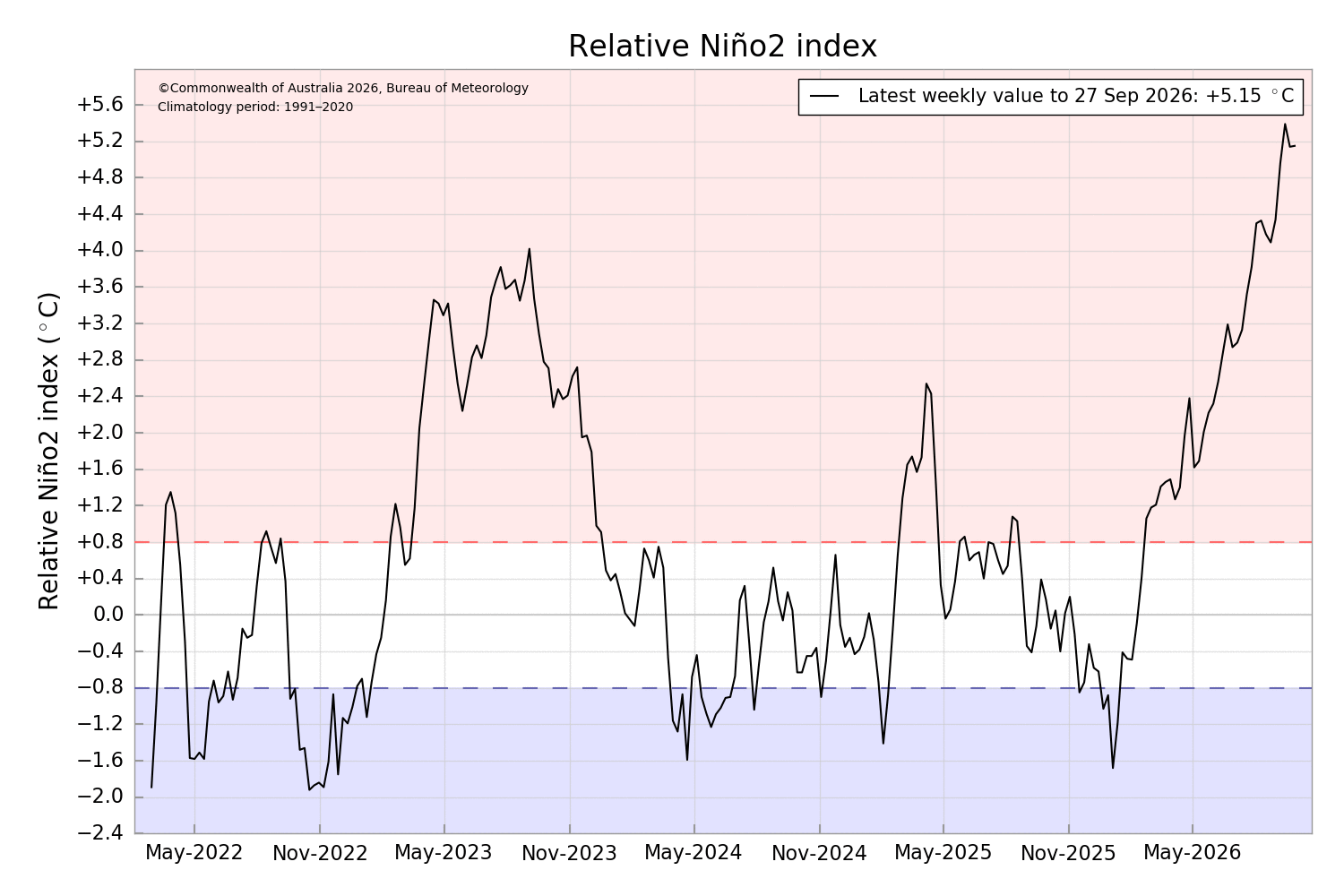
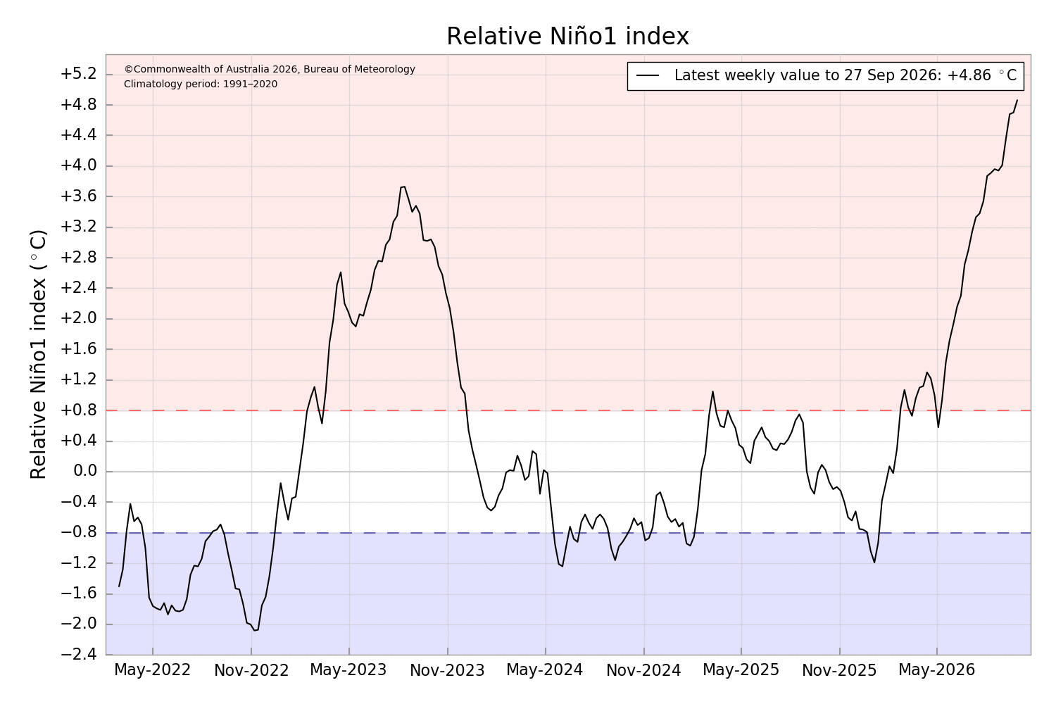
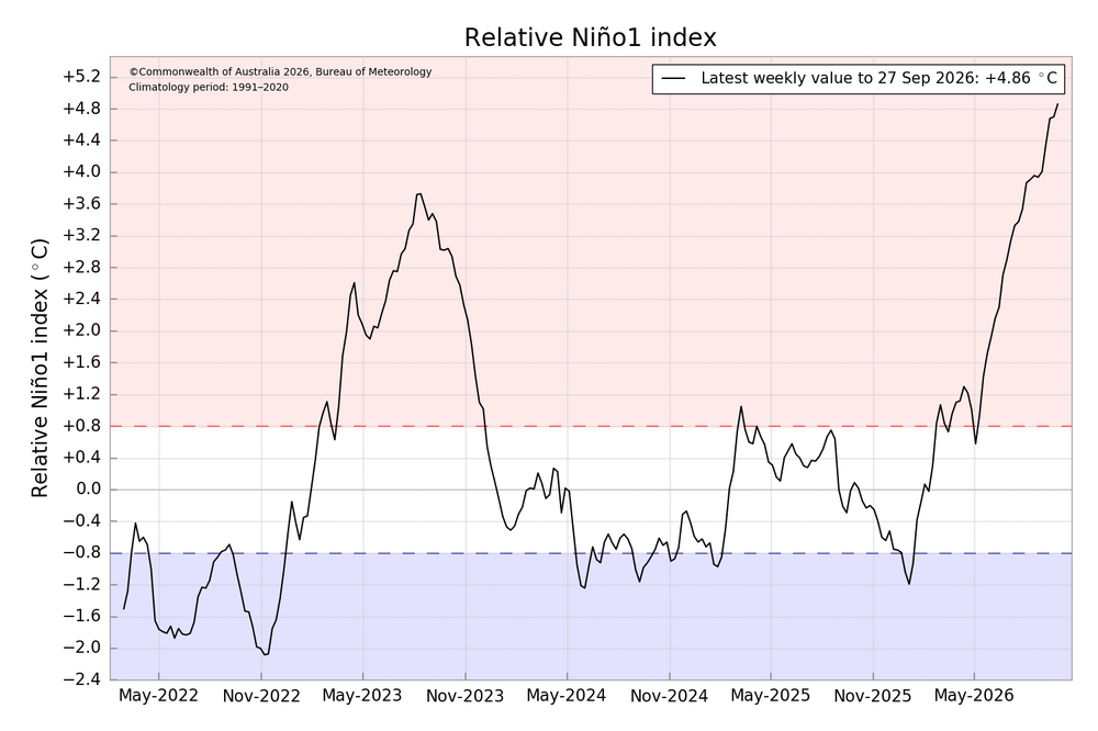
RONI is a relative metric to SST outside the actual ENSO regions. But the BOM RONI for Nino 1 and 2 are higher close to the actual ONI readings. So this is why we maintain the ONI alongside the RONI. Plus the agencies in South America use both since the record streak of temperatures there are related to the actual ONI readings. Remember Nino 1+2 has been one of the few ocean regions of the planet which didn’t warm prior to the 2023-2024 super El Niño.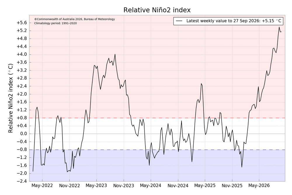
-
TWC is showing LGA at 84 on Friday. Meanwhile, NWS and AW top out in the upper 70s for LGA on Friday. Who's going to be right here?
-
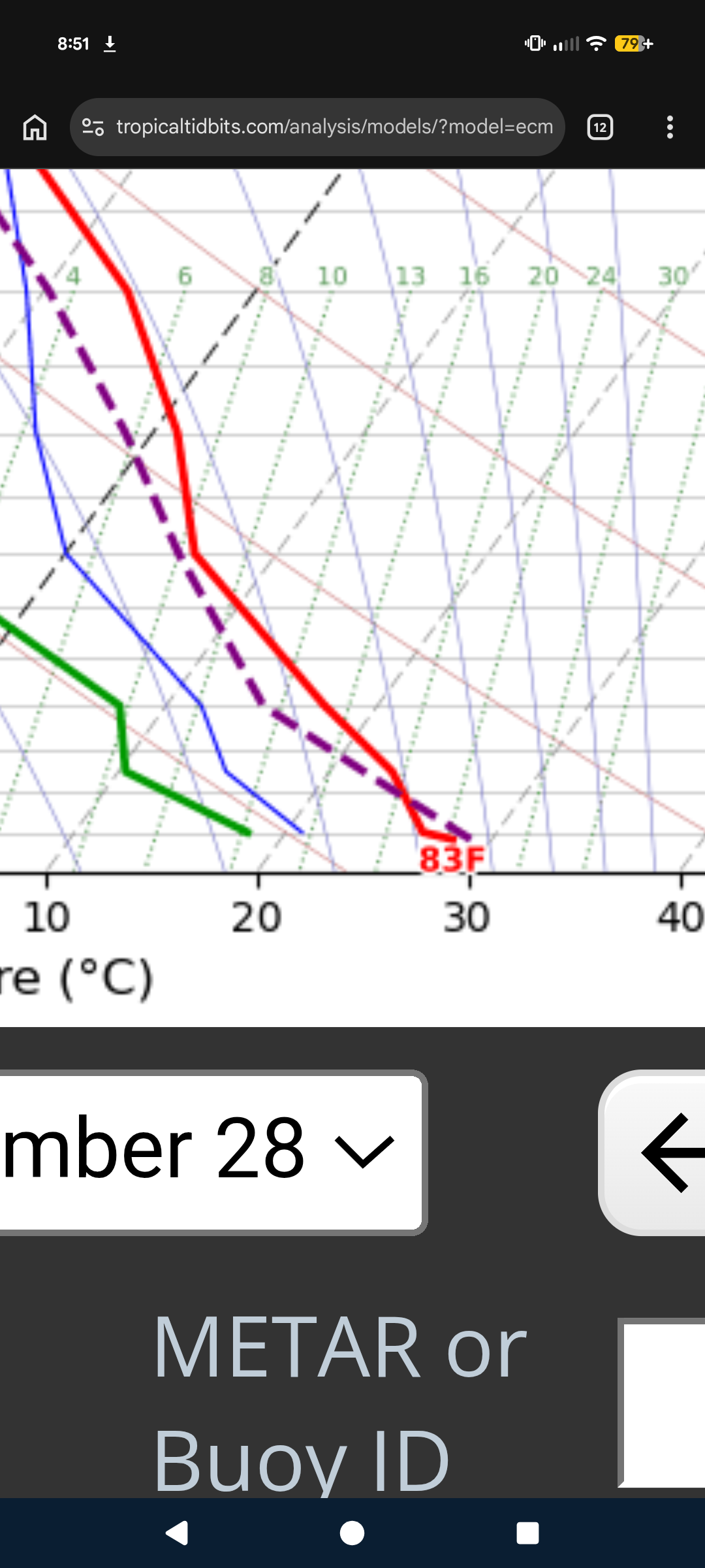
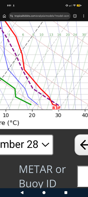
this euro sounding for friday in central nj isn't mixed out enough. these people never learn
-

October Comes Early: Late September Multi-Hazard Hybrid Storm
Brian5671 replied to WxWatcher007's topic in New England
About 1.75 here-happy to not be in the rainfall JP for once! -
The 0Z UKMET like prior runs going back days continues to keep Fay alive through the entire run. It has Fay at her strongest late in the run only barely missing going back to TS strength! TROPICAL DEPRESSION FAY ANALYSED POSITION : 28.7N 44.0W ATCF IDENTIFIER : AL062026 LEAD CENTRAL MAXIMUM WIND VERIFYING TIME TIME POSITION PRESSURE (MB) SPEED (KNOTS) -------------- ---- -------- ------------- ------------- 0000UTC 28.09.2026 0 28.7N 44.0W 1015 23 1200UTC 28.09.2026 12 27.4N 44.6W 1014 23 0000UTC 29.09.2026 24 26.4N 45.6W 1013 22 1200UTC 29.09.2026 36 25.4N 47.2W 1013 22 0000UTC 30.09.2026 48 24.7N 48.9W 1012 23 1200UTC 30.09.2026 60 24.3N 51.1W 1013 25 0000UTC 01.10.2026 72 24.1N 53.1W 1013 27 1200UTC 01.10.2026 84 24.6N 55.1W 1014 24 0000UTC 02.10.2026 96 25.2N 56.6W 1014 24 1200UTC 02.10.2026 108 26.2N 58.0W 1013 27 0000UTC 03.10.2026 120 27.1N 58.8W 1012 31 1200UTC 03.10.2026 132 28.2N 59.1W 1010 33 0000UTC 04.10.2026 144 29.0N 58.9W 1009 33 1200UTC 04.10.2026 156 29.7N 58.5W 1009 34 0000UTC 05.10.2026 168 30.1N 57.9W 1009 31
-
Mid 80's is aggressive especially with wet ground, but I think some places will make a run at 80-Wed-Fri
-

2026-2027 Record-breaking El Nino
40/70 Benchmark replied to Stormchaserchuck1's topic in Weather Forecasting and Discussion
Yes, but you keep neglecting the fact that did in fact begin severely east-based. No, the stratospheric conditions were different due to the QBO (west this year and 1982, east in 1997) and the solar cycle (high and descending this year and 1982 versus low and ascending in 1997), not ENSO. I think there is some connection between ENSO and the solar cycle on a larger scale, which is why the most intense El Nino events usually coincide with descending solar, post max, but it's more solar driving ENSO, not vice versa ENSO orientation does have some direct impact on the NAO, but it's more Modoki that specifically favors -NAO....basin-wide is more variable and depends on other extraneous factors, such as the strat, and solar cycle. No guidance forecasts the warm pool to near the Mexican coast....if you have anything that does, then by all means...present it. Could it make it further east than all guidance currently depicts, sure....not I doubt it's off by that much. Guidance places forcing in a very similar spot to 1983 despite any disparity in the orientation of El Nino in the respective of years bc of where that pool of 30c+ water resides. . -
Strong Nor'Easter/Hybrid Storm Late September 2026
Brian5671 replied to Rjay's topic in New York City Metro
still raining some here but mostly over. About 1.75 storm total. Happy to miss the bigger amts seen elsewhere -

October Comes Early: Late September Multi-Hazard Hybrid Storm
WinterWolf replied to WxWatcher007's topic in New England
What a complete soaker….congrats to those that are pushing 8-10”…that’s impressive. By the time it’s done we should be in the 4” range here. -

E PA/NJ/DE Autumn 2026 Obs/Discussion
The Iceman replied to PhiEaglesfan712's topic in Philadelphia Region
.4” overnight and into this morning. 2.5” on the storm. Still light rain/misting this morning. -

2026-2027 Record-breaking El Nino
Typhoon Tip replied to Stormchaserchuck1's topic in Weather Forecasting and Discussion
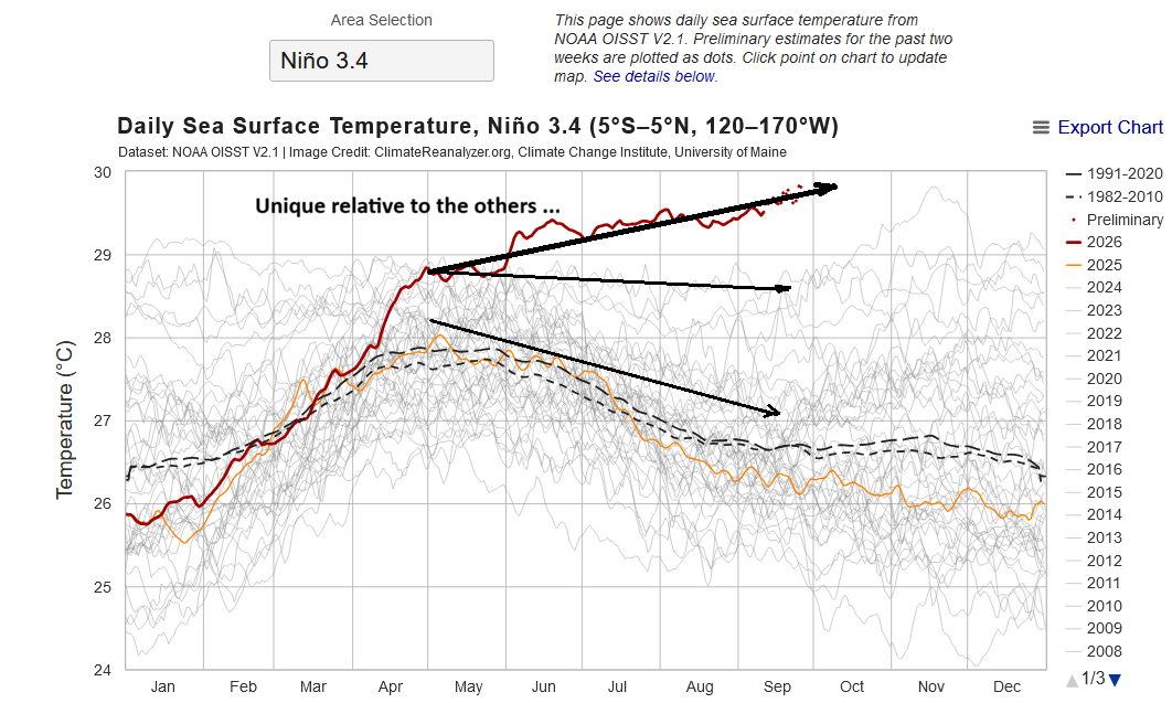
Man ...that 3.4 is astounding really. Just a cursory evaluation and comparison of these curves, https://climatereanalyzer.org/clim/sst_daily/?dm_id=nino3.4 .. what sets this year apart is that every curve there, other than the present year's ongoing ... demoed a period of downward trajectory between mid spring to early autumns. One can make that out just eyeballing, but if you looked at May1 to September15-ish period trend lines, even 2015 was slightly negative during that span of time. Otherwise, they were more demonstratively so. Yet, the 3.4 has risen the entire time... straight through what one can only surmise was/is a climate normal behavior for an intermediate nadir. So, for first time at least among these years since 2008 there was no intermediate negative recovery. I wonder if this would be so for all years - It's a nuance ob but it's true nonetheless. The other obvious elephant in this picture is that this 3.4 is like that jet at a memorial fly by that peals away toward the heavens.. I just find that specific aspect about the trend line since May 1/summer behavior to be interesting for unique behavior.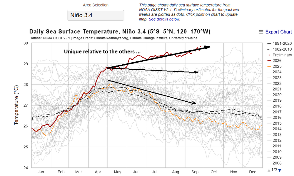
-
Up to 1.37" for the storm and 5.79" for the month. The radar indicates I should pass 6" for September.
-
 1.3.
1.3. -

October Comes Early: Late September Multi-Hazard Hybrid Storm
dendrite replied to WxWatcher007's topic in New England
53° -DZ 0.86” -
 Cialis over the counter: TadaStream - Generic Tadalafil 20mg price
 -
2026-2027 Record-breaking El Nino
bluewave replied to Stormchaserchuck1's topic in Weather Forecasting and Discussion
The east based nature of 1982-1983 backed off during the winter relative to 1997-1998. The stratospheric conditions were related to the different nature of the ENSO forcing between both those seasons. The Central Pacific warm pool has already shifted the farthest to the east it has ever been. This is only expected to increase in the coming months. -
it's raining