All Activity
- Past hour
-
Updated PRISM here (through Christmas day). We've been tacking on 0.5F+/day during this Torchmas pattern. Probably around ~+3.2F once updated through yesterday.
-
4.3" In basketball parlance we'd call that a make-up-call.
-

December 2025 regional war/obs/disco thread
Snowcrazed71 replied to Torch Tiger's topic in New England
Never been a fan of this guy. He usually is very warm biased, and had mentioned that for January, now he's on the suppression wagon LOL. Just don't like his forecasting. He's not consistent -

Wounded Duck Strikes Back: Dec 26 & 27th Winter Storm Obs
The 4 Seasons replied to WxWatcher007's topic in New England
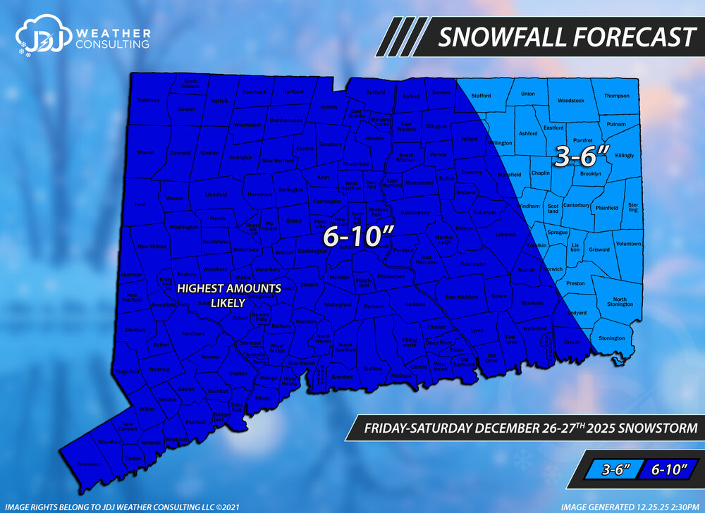
Connecticut Snowfall Totals. This is just a first pass map, there will be a more complete one coming with a full SNE map when i get some time over the next day or two. If there are any additional reports or errors let me know and ill look into it and fix them. Thanks to everyone who sent a report. Overall the forecast was very solid. Pretty much everyone fell within the ranges and the ranges were appropriate for CT. A little too high for Hartford, Tolland counties but that's about it, ill have a full picture once all the maps are done but m feeling an A- ish.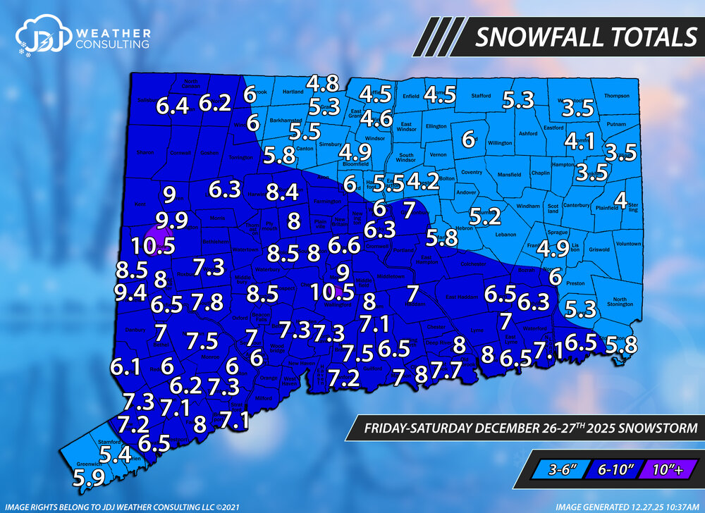
-
You're fine. They always (90%+) drift north. Ask Connecticut posters.
-

Wounded Duck Strikes Back: Dec 26 & 27th Winter Storm Obs
Brewbeer replied to WxWatcher007's topic in New England
looks like a solid 4+ here, 23/17 -
Don when was the last 4 inch daily snowfall in the park? A dubious record for sure, you could technically have 7.8 inches of snow from one storm and still keep that record intact.
-
15z RAP also really cold only difference is less precip compared to the HRRR. hmmm
-

Wounded Duck Strikes Back: Dec 26 & 27th Winter Storm Obs
bmj16725 replied to WxWatcher007's topic in New England
Final of 8.5" here - up to 10.25" for December. -
We finally have a big storm heading towards the Upper Midwest. That was probably the pattern changer that much of CONUS needed. In the wake, there will be artic air and renewed chances for snow from an active STJ running into cold air. We were definitely in the minority over the past 2 weeks, much of CONUS was torching. Similar to early Jan 2024, looks like we have a big storm over the northern tier to shake up that death ridge over Central US. Without that ridge there, it becomes much easier for most of the country to have more chances for snow.
-
It’s December. The last event was mid December. There’s never a long lasting snowpack for all of december
-

Wounded Duck Strikes Back: Dec 26 & 27th Winter Storm Obs
Chrisrotary12 replied to WxWatcher007's topic in New England
I don’t measure. Guessing 1.5-2” of pure fluff. -

Wounded Duck Strikes Back: Dec 26 & 27th Winter Storm Obs
TheSnowman replied to WxWatcher007's topic in New England
When even Cory is elated in the ultimate screw zone ova heeere with 4”, it Must have been good -
What's your season to date now in Saugerties?
-

Wounded Duck Strikes Back: Dec 26 & 27th Winter Storm Obs
BrianW replied to WxWatcher007's topic in New England
Yeah. A rare winter where I believe BDR is the leader for snow totals in CT right now... -
But wouldn't THAT be sweet?
-
JAMMIN JANUARY IS COMING
-
HRRR was still going after that.. woah
-
Sure it’s a Niña but it’s also been 30 years since that level of delivery in a Niña.
-
I think they also use an estimate for the daily snowfall as they do not measure at both 12am and 1am. They did for awhile but for the last 4-5 years have stopped doing that. The official daily total was 1.7 I think. I have no idea what they used to do pre 92-93. I was told years back they just had the HMT/Intern drive up to a spot in the park from the NWS office at Rockefeller and measure at 12/1/7/1/7 respectively.
-
12z HRRR went wild with ice here.. even half would be fun .. GFS also came in colder at 12z
.thumb.png.5352422b9c9caa93aa5be9fd5d62c2f8.png)
-

Central PA Winter 25/26 Discussion and Obs
Itstrainingtime replied to MAG5035's topic in Upstate New York/Pennsylvania
Temp still below freezing here with very little melting so far. -
Lol thanks
-
50°+ warm ups with or without rain have become much more common prior to and following snow events here than they used to be.
-
Central Park had 0.3" at 7pm, 2.3" at 1am and 4.3" at 7am. It's tough to say bc they don't measure between hours. Using that info I could say we probably didn't break the streak on the 4" snowfall day but I'm not sure if there's a way to know. Don or Bluewave will probably chime in.


.png.f7b041503c54c070443edefab9afbcc6.png)

