All Activity
- Past hour
-
49..maybe 50 before we get that refreshing spring air off Cape Cod bay
-
Another mid summer day. I bet DC easily breezes by 90 degrees today. We're the Tug Hill of heat. We get heat like they get snow. Super easy and always busting high.
-
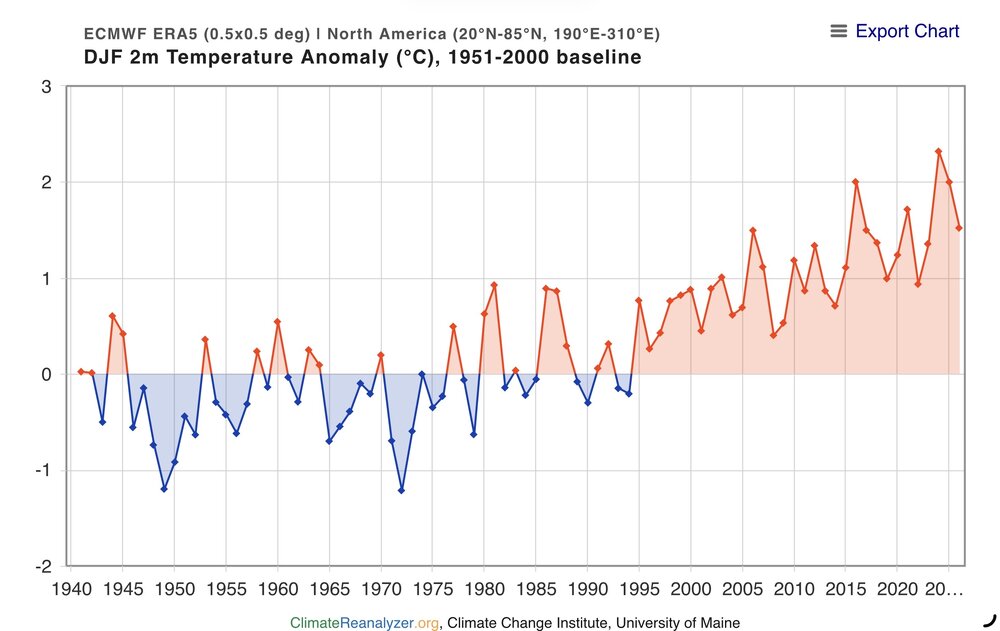
I would say that the cold this winter in parts of North America was uneventful compared to what we used to get in the past. Sure some localized areas did see intervals of record cold. But the areas of record warmth overpowered the colder ones so North America still finished with a significantly warmer winter than the old days at +1.522 C during DJF 2025-2026. This winter was the 5th warmest on record for North America.The record highs were of a greater ranking and number than the areas of record cold. The last colder winters for North America occurred back in 2003 and especially 1994. The warmest winter on record was 2023-2024 with 2024-2025 experiencing the 2nd warmest winter. So our warmest winters are becoming warmer with a shrinking winter cold pool. Each jump in global temperatures like we saw in 2015-2016 and 2023-2024 raises the bar for record warmth even higher. This is why the warming acceleration over the last decade is so significant. https://climatereanalyzer.org/research_tools/monthly_tseries/
-
59. Pope needs to come here.
-
 DCA: +3.8 NYC: +2.7 BOS: +2.5 ORD: +3.9 ATL: +5.2 IAH: +3.5 DEN: +2.0 PHX: +2.0 SEA: +0.3
 -
Special for you, the mountains of Switzerland. Amazing up here.

-
Rhodies blooming. Thankfully no more freezes.
-
Leaves pop?
-
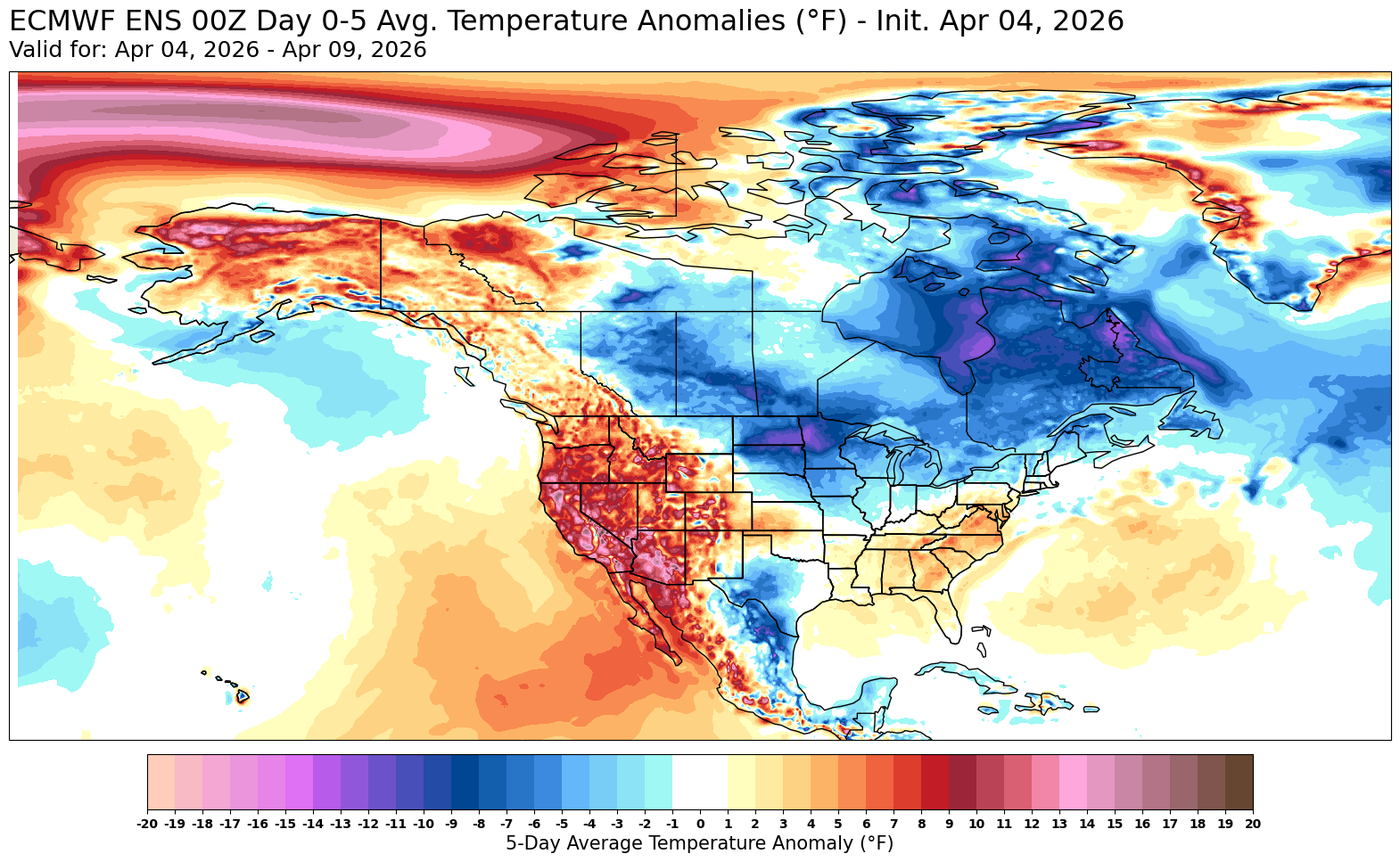
Even though we are averaging out on the warmer side, this is still a very active backdoor pattern for this time of year. Big spread on the highs between NJ and the CT Shoreline. Looks like this back and forth with the warmer days being more impressive than the cooler days will continue. Data for NEWARK LIBERTY INTL AP, NJ Click column heading to sort ascending, click again to sort descending. 2026-03-08 73 24.7 2026-03-09 73 24.5 2026-03-10 82 33.2 2026-03-11 82 32.9 2026-03-12 64 14.6 2026-03-13 45 -4.7 2026-03-14 53 3.0 2026-03-15 46 -4.4 2026-03-16 67 16.3 2026-03-17 47 -4.0 2026-03-18 37 -14.3 2026-03-19 44 -7.7 2026-03-20 66 14.0 2026-03-21 60 7.6 2026-03-22 64 11.3 2026-03-23 52 -1.1 2026-03-24 50 -3.5 2026-03-25 55 1.2 2026-03-26 77 22.8 2026-03-27 65 10.4 2026-03-28 45 -10.0 2026-03-29 58 2.6 2026-03-30 73 17.2 2026-03-31 82 25.8 2026-04-01 81 24.4 2026-04-02 54 -3.0 2026-04-03 67 9.6 Data for IGOR I SIKORSKY MEMORIAL AIRPORT, CT Click column heading to sort ascending, click again to sort descending. 2026-03-08 57 12.0 2026-03-09 64 18.7 2026-03-10 59 13.5 2026-03-11 58 12.2 2026-03-12 55 8.9 2026-03-13 40 -6.3 2026-03-14 49 2.4 2026-03-15 39 -7.9 2026-03-16 56 8.8 2026-03-17 55 7.5 2026-03-18 35 -12.8 2026-03-19 38 -10.1 2026-03-20 50 1.6 2026-03-21 54 5.3 2026-03-22 48 -1.0 2026-03-23 49 -0.4 2026-03-24 46 -3.7 2026-03-25 47 -3.1 2026-03-26 64 13.6 2026-03-27 57 6.2 2026-03-28 44 -7.1 2026-03-29 49 -2.5 2026-03-30 65 13.1 2026-03-31 72 19.8 2026-04-01 70 17.4 2026-04-02 49 -4.0 2026-04-03 55 1.6

-

2026-2027 El Nino
snowman19 replied to Stormchaserchuck1's topic in Weather Forecasting and Discussion
IMO this is going to be a high-end strong El Niño at minimum with the chances of a super event growing very quickly -
Darn dogs got me up early, walking at 530am temp was 58. Now 52 breezy, was a nice sunrise.
- Today
-
52/42 Gonna be a fight to stay here through early afternoon.
-

Central PA Spring 2026 Discussion/Obs Thread
mahantango#1 replied to Voyager's topic in Upstate New York/Pennsylvania
Hazardous Weather Outlook National Weather Service State College PA 603 AM EDT Sat Apr 4 2026 PAZ012-018-019-024>028-033>036-041-042-045-046-049>053-056>059- 063>066-051015- Northern Clinton-Northern Centre-Southern Centre-Cambria-Blair- Huntingdon-Mifflin-Juniata-Somerset-Bedford-Fulton-Franklin- Northern Lycoming-Sullivan-Southern Clinton-Southern Lycoming-Union- Snyder-Montour-Northumberland-Columbia-Perry-Dauphin-Schuylkill- Lebanon-Cumberland-Adams-York-Lancaster- 603 AM EDT Sat Apr 4 2026 This Hazardous Weather Outlook is for central Pennsylvania. .DAY ONE...Today and tonight. Strong to severe thunderstorms with gusty winds are possible this afternoon, and again later tonight. .DAYS TWO THROUGH SEVEN...Sunday through Friday. The probability for widespread hazardous weather is low. .SPOTTER INFORMATION STATEMENT... Spotters are encouraged to report significant hazardous weather. -
Central PA Spring 2026 Discussion/Obs Thread
mahantango#1 replied to Voyager's topic in Upstate New York/Pennsylvania
NWS really cut back the precipitation amounts for today and tomorrow. -

E PA/NJ/DE Spring 2026 Obs/Discussion
Birds~69 replied to PhiEaglesfan712's topic in Philadelphia Region
I'm praying for a 5 month back door cold front... 53F -
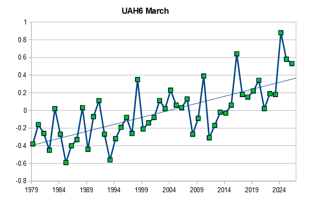
A couple of comments: 1) Yes, Roy is a long time climate dismissive 2) His dataset misses much of the warming in the early 2000s, 3) Best to look at the globe as a whole to judge warming, 4) Global UAH is more sensitive to ENSO than surface temperatures.5) Global UAH was very warm for a La Nina in March, the first La Nina well above the linear trend. We've reached the La Nina bottom in UAH. A typical nino spike in UAH from these levels would be hard to dismiss.
-
Lol
-
Last snow Tuesday?
-

2026-2027 El Nino
dmillz25 replied to Stormchaserchuck1's topic in Weather Forecasting and Discussion
What are your thoughts thus far about where this niño could be headed? Basin wide strong seems like it could be in the works but obviously its still too early to know -
Daily record warm low secured (62). This is tied with 3/27/1998 as the only days this early in the season to have a low of 62 or higher in the Pittsburgh International era. This is also already the third day this year with a low in the 60s, moving ahead of last year for the most so early in the season at Pittsburgh International (1952-present). These are the only years to have more than one. Number of days on or before April 3rd to have a low in the 60s at Pittsburgh International: 1952-2024: 4 2025-2026: 5 This is getting to be like the steroid era in baseball.
-
Let's see if we can shake off some drought the rest of this Spring-Summer-Fall. What do you all think?
-

Mountain West Discussion
mayjawintastawm replied to mayjawintastawm's topic in Central/Western States
Well, it's April. 26.2" snow this season (15th out of my 16 winters here, after 2011-12), may not be over yet but time to start a new thread for the "warmer half" of the year. -
73F at midnight. We've had a number of nights like this over the past month. Pretty abnormal for this time of year.
-
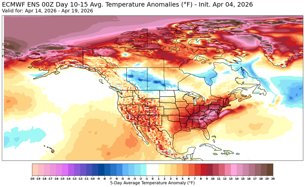
“It is human nature to think the weather we experience has some sort of global significance. But look at NOAA’s best estimate of March 2026 temperature departures from “normal” (1991-2020 average) over North America (below). Yeah, the U.S. was unusually warm. But what about all the unusual chill over the northern parts of North America? Alaska and most of Canada were below normal. As part of our monthly global temperature updates (posted separately) here are the March temperature departures from normal for the lower troposphere, 1979 through 2026 in the Lower 48 (top panel of Fig. 2). Last month was clearly the warmest in the 48-year satellite temperature record. But when we examine the bottom panel in Fig. 2 we see that, averaged over all land areas of the Northern Hemisphere (including Canada and Alaska), March 2026 was uneventful, and was even cooler than 2024 and 2025. In fact, 2026 was right on the long-term trend line. The message here is that the unusual (and likely record) warmth of March 2026 in the U.S. was largely due to normal month-to-month weather variations, while the large-scale climate signal shows March was a continuation of the slow (and largely benign, and possibly even beneficial) warming trend we have been experiencing in recent decades.” https://www.drroyspencer.com/2026/04/march-2026-satellite-temperatures-record-warmth-in-u-s-but-uneventful-for-the-northern-hemisphere/
-
Wow, that is really cool. Love that old vibe, so much simpler.