All Activity
- Past hour
-
40° today? I think so
-

2025-2026 ENSO
40/70 Benchmark replied to 40/70 Benchmark's topic in Weather Forecasting and Discussion
Pretty close to a full split.....I would wait to see what actually verified because I still anticipate a full split, more akin to 2018 and 2023. -

2025-2026 ENSO
so_whats_happening replied to 40/70 Benchmark's topic in Weather Forecasting and Discussion
All this to say I do want to go out with a bang for the season but my hopes are slowly fading like the winter season.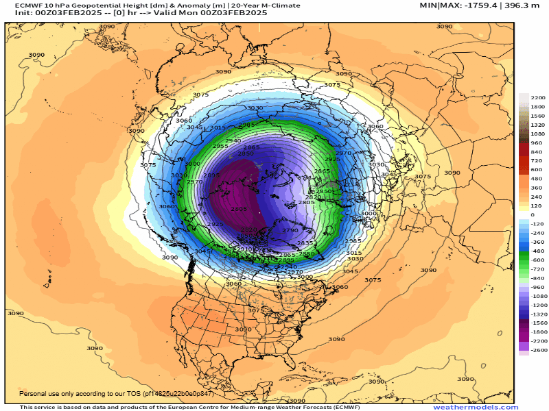
-
2025-2026 ENSO
40/70 Benchmark replied to 40/70 Benchmark's topic in Weather Forecasting and Discussion
Yea, we'll see...I certainly don't expect a perfect forecast from 3 months lead. -
I am looking forward to my trip up at the end of February and hoping the snowy weather holds up. Of course we just had that epic storm where I was and I was in the screw zone dry slot (we only got 4 inches). I did chase to where some of the big amounts occurred though because I wasn't going to sit through that nonsense. The amazing thing for NC is it was in the teens for this storm with 20:1 ratios and better in some cases. Here is a pic from that chase in the FGEN band. See you all soon!
-
Mping says yes: https://mping.ou.edu/display/
-
2025-2026 ENSO
so_whats_happening replied to 40/70 Benchmark's topic in Weather Forecasting and Discussion
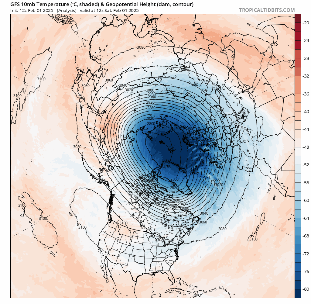
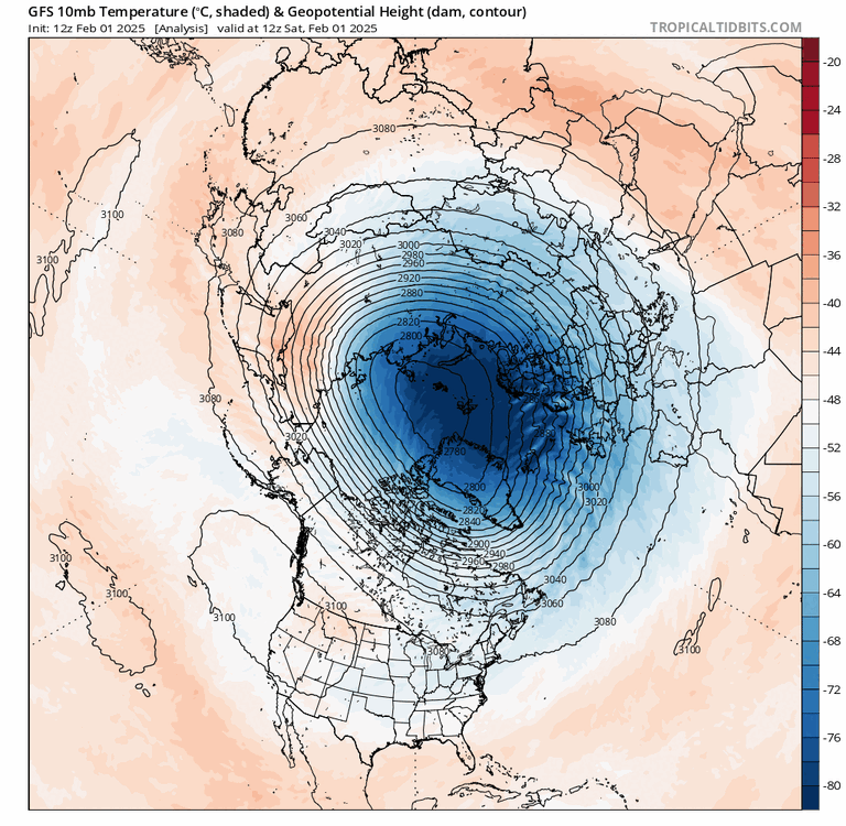
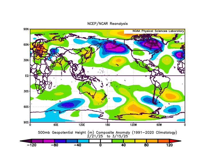
Unfortunately it still looks as though things will be intact through Strato to Tropo. There has been residual high latitude blocking on the Pacific side of the arctic a lot this season which has allowed us to remain relatively cold through many of the months. If we can hold that pattern into the second half of February as things relax yet again I would not be surprised at a similar progression as we saw in January for February. The SPV just does not get demolished like we typically want to see. Well again we saw something similar to this last year around this time. From about the 3rd week of February to mid March there really was not a whole lot that took place. I want to say there was a quick snowfall that snuck in but this was the overall pattern at 500mb after the event took place. The graphs below show a funky wave 2 tried to set up but ultimately ended up being a wave 1 event and tiny lobe was over Greenland for a bit. Similar things don't always produce the same event but I wouldn't expect much out of this if we go down that path. That is actually fairly typical in split events (if the split event were to occur) the larger more intact lobe goes to Eurasia while a piece splits off to our side. It is the lack of a true split that leads to almost being another wave 1 displacement event again fairly similar to last year at this time. This was what the Euro and GFS had leading up to the event. I wish I had saved the later portion but I guess I deleted stuff.
-
-
Got 1.4" of fluff here yesterday. Season to date snowfall is 36.3" imby and 35.3" at DTW. Deep winter continues.
-
-

February 2026 Medium/ Long Range Discussion: Buckle Up!
Heisy replied to Weather Will's topic in Mid Atlantic
Only issue is as of yesterday’s runs it’s getting away from a full reversal. We’ll see how today’s charts look -

Jan 30th-February 1st 2026 Arctic Blast/ULL Snow OBS Thread.
fountainguy97 replied to John1122's topic in Tennessee Valley
End total for me was 12" and got down to -1. Overall an incredible event which was by far my largest snow in the 7 years I've been here. -
Detroit finished January with a mean temp of 20.6F (-5.2F), precip 1.43” (-0.80”) and snowfall 17.1” (+3.1”). Snow depth of 1”+ covered the ground for 23 of the 31 days, peak depth 9” on multiple days.
-
I bought a ambient station back in 2020. Best investment ever for MBY. Upgraded to in 2024 to a newer model. The price point for Ambient is not steep.
-

Feb 4-5 significant SE snow threat
WinstonSalemArlington replied to GaWx's topic in Southeastern States
-

February 2026 Medium/ Long Range Discussion: Buckle Up!
Maestrobjwa replied to Weather Will's topic in Mid Atlantic
Still feel like that window will be our last chance for snow until March (unless guidance shows something different for late Feb?). Saw in another thread the timing of the SSW is similar to 2018... -
Records: Highs: EWR: 64 (1991) NYC: 64 (1991) LGA: 64 (1991) JFK: 62 (1991) Lows: EWR: 1 (1955) NYC: 0 (1955) LGA: 1 (1955) JFK: 6 (1961) Historical: 1803: Winston Salem, North Carolina: The region is hit by 20 inches of snow. (Ref. WxDoctor) 1844: Boston Harbor was so thick with ice on this date that a channel had to be cut through the ice for the "Britannia" ship to leave with 30,000 letters for England. 1917 - Downtown Miami, FL, reported an all-time record low of 27 degrees. (David Ludlum) 1917: Locations that reported daily record lows included: Atlanta, GA: 2°, Roanoke, VA: 2°, Lynchburg, VA: 3°, Richmond, VA: 6°, Raleigh, NC: 9°, Norfolk, VA: 9°, Montgomery, AL: 10°, Wilmington, NC: 13°, Savannah, GA: 13°, Pensacola, FL: 17°, Mobile, AL: 19°, Tampa, FL: 26 °F. (Ref. Wilson - Additional Temperatures Listed On This Link) 1947 - The temperature at Tanacross, AK, plunged to a record 75 degrees below zero. (David Ludlum) 1947: Gulkana, AK set an all-time record low with -65°. McGrath and Fairbanks reported February record lows with -64 °F and -58 °F respectively. Locations that reported daily record lows included: King Salmon, AK: -32°, Homer, AK: -16°, Juneau, AK: -10 °F and Cold Bay, AK: -7°. The temperature dropped to -81° at Snag, Northwest Territories Canada, North America's lowest recorded official temperature, capping a week of intense cold in the Yukon.(Ref. Wilson Wx. History) Coldest recorded Canadian temperature is -81° at Snag, Yukon Territory (Ref. Much Additional Information About This Extreme Record) (Bob Ryan's 2002 Almanac) 1952: South Florida on February 2nd & 3rd: South Florida: South Florida hit by the only tropical storm of record, known as the Groundhog Day Storm to hit the U.S. in February. Storm moves out of the Gulf of Mexico with 60 mph winds and two to four inches of rain. (Ref. WxDoctor) 1959: At 12:55 am Central Time, a plane took off from runway 17 at the Mason City, Iowa airport, carrying the lives of Buddy Holly, Ritchie Valens, and J. P. "The Big Bopper" Richardson. At the time of departure, the weather was reported as light snow, a ceiling of 3,000 feet with sky obscured, visibility 6 miles, and winds from 20 to 30 mph. At around 9:35 am, Hubert Jerry Dwyer spotted the wreckage less than 6 miles northwest of the airport. The three musicians and the pilot died from this crash. 1961: On this date through the 5th, a large part of the Northeast and New England were reeling under their third great snowstorm of the winter. The Blizzard dumped 17.4 inches of snow on New York City, NY. Gale force winds blew the snow into 10 foot drifts that blocked city streets. Automobile travel was banned in New York City, NY for almost a week. Snowfall totals in other locations ranged from 10 to 24 inches in parts of Pennsylvania and 12 to 27 inches in parts of New Jersey. States of emergencies were declared. 73 people died as a result of the storm. Baltimore, MD set a record low with 4°. Ref. (NWS Ranking for Storms between 1956 and 2011) This is the 5th Worst Snowstorm (Ref. Wilson Wx. History) Snowstorm dumped 16 inches of snow on Frederick, MD (Bob Ryan's 2002 Almanac) Cold & windy snow, hit like a blizzard with severe cold and gale force winds. Eight inches fell in Washington, DC and 2 to 13 inches across Virginia with as much as 36 inches in New York. There four fatalities in Virginia. (Ref. Virginia Weather History) 1963: High pressure across the Great Basin brought record heat to parts of the West. February's record maximum temperature in the United States was set as Montezuma, AZ soared to 105°. Los Angeles (LAX), CA set their February record high with 92 °F. (Ref. Wilson Wx. History) 1986: A 5-day ice storm of freezing drizzle and fog through the 5th caused ice to accumulate 5 to 8 inches thick across central North Dakota. Many people were left without power. The ice in Wisconsin felled millions of trees. (Ref. Wilson Wx. History) 1987 - Wintry weather was confined to freezing drizzle and light snow in the northeastern U.S., and light rain and snow in the western U.S. (The National Weather Summary) 1988 - Arctic air continued to invade the central U.S. The temperature at Midland TX plunged from a record high of 80 degrees to 37 degrees in just three hours. Morning lows in the higher elevations of Wyoming were as cold as 38 degrees below zero. Heavy snow blanketed southwestern Colorado, with 16 inches reported at Steamboat Springs. (The National Weather Summary) (Storm Data) 1989 - A winter storm brought heavy snow and high winds to the western U.S. Up to three feet of snow blanketed the Sierra Nevada of California, and buried parts of northeastern Washington State under three feet of snow in five days. High winds across Washington State reached 75 mph, with gusts to 105 mph. (The National Weather Summary) (Storm Data) 1989 - Severe cold gripped the north central U.S. The morning low of 29 degrees below zero at Casper WY was a record for the month of February. Wisdom MT hit 53 degrees below zero. Missoula MT reported a wind chill reading of 85 degrees below zero. (The National Weather Summary) 1990 - Thunderstorms developing ahead of a cold front produced severe weather over the central Gulf coast states during the afternoon and evening hours. Thunderstorms spawned seven tornadoes in Alabama, including one which touched down north of Birmingham injuring fifteen people and causing nearly three million dollars damage. A tornado at Margaret injured eleven persons and caused a million dollars damage. (The National Weather Summary) (Storm Data) 1996: February second and third Annandale Weather Center recorded 9.3 inches of snow in two snows in 24 hrs. (Ref. Annandale Weather Records) The temperature in Iowa plunged to 47° below zero, a record for the state Feb. 2 - 3 A continuing series of Alberta clippers followed by strong Nor'easters struck the Commonwealth. The storm on February 2-3 dropped one to two feet of snow from to Charlottesville, Fredericksburg and across the Northern Neck. To the north of the heavy snow band fell 6 to 10 inches of snow and to the south of the band was a significant ice storm. Some counties along the North Carolina border saw about half of its population lose power. The ice caused about a half million dollars in damage and caused widespread disruptions in the Hampton Roads area. (Ref. Virginia Weather History) 1997: Centralia, Washington State: Centralia sets the state record for consecutive days of precipitation at 55 between 10 November 1996 and 3 February 1997. (Ref. WxDoctor) 1999: It was a dangerous job for both the rescued and rescuer. The Northern Aurora (12 men on board) capsized in high seas/freezing spray in AK’s Resurrection Bay. The Coast Guard rescued 1. USGC report noted N winds to 58 mph, seas to 8 feet, heavy fog, and wind chills to -65 degrees. (Ref. Weather Guide Calendar with Phenomenal Weather Events 2011 Accord Pub. 2010, USA) 2006 Lubbock, TX recorded their first measurable rain, 0.03 inches, in 98 days, ending their longest period on record without measurable precipitation. The temperature plunged to record low of -56° at Point Lay, AK. Kodiak, AK reported a record low of -8°.(Ref. Wilson Wx. History)
-
About 28" so far. Almost all nickel and dimes. Still waiting on a biggie(10"+). Everyone else has gotten one.
-
Huntington Bay iced in. Impressive stuff

-
-1° for the low.
-

Central PA Winter 25/26 Discussion and Obs
pasnownut replied to MAG5035's topic in Upstate New York/Pennsylvania
Etown for today per NWS Today Occasional flurries before noon. Cloudy, with a high near 33. -
It would take a pretty sharp reversal to get decent cold anomalies in the plains compared to current guidance for Feb. We are going to be roasting at least first third if not first half of the month, like +10 F above normal if not more for my area. Of course January was like that and we still ended below normal because the last third of the month was so cold. But assuming models trend more favorably after any SSW maybe we still have time. I don't think it would take much of an eastward shift in the pattern mid month to turn that western trough into GB/Plains trough.
-
Anyone seeing this backend feature on the HRRR? NAM shows this too , interesting
-
Central PA Winter 25/26 Discussion and Obs
pasnownut replied to MAG5035's topic in Upstate New York/Pennsylvania
Here was etowns warmest from NWS for yesterday. Just sharing for continuity's sake. 02 14:56 NW 12 10.00 Fair CLR 30.9 8.1 38% 22 30.1 1019.7 -
But it is a matter of a scale. There are events that take place regardless of indexes; they may seem like they were anti-correlated when they do. However, the restoring forces were required by smaller mass field disruptions, taking place intra index. I personally call these sub-index events.