All Activity
- Past hour
-
High of 29F here - spiked when the sun came out briefly here. Been steady around 25 since around 4pm and now slowly rising.
-
yep - this is some proper cold.
-
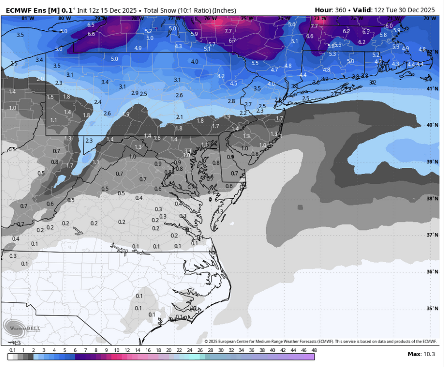
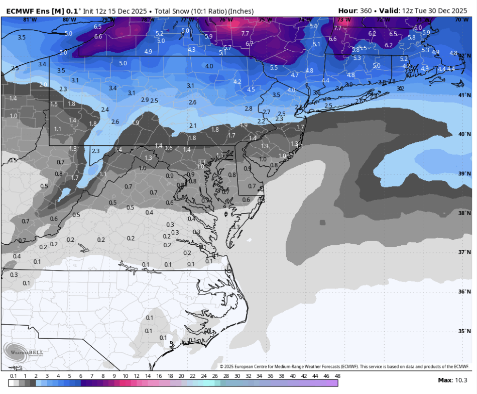
I doubt this is the end for December, especially on the tracking side of things. EPS and GEFS have around an inch of snow for most of the area (mean, not median) for the remainder of the month.
-
they need some serious soul searching in the off season.
-
31.5/15.8 today.
-
34.7 was the high, low was 14.5 this morning. Already down to 26.0
-
I'm already rising, so my high was 16.9 around 3:30 (or so I thought), fell to around 15 a few hours ago and is now 17.5 and continues to slowly rise. You may not be far behind.
-
IDK why NWS has decided to play the game with storm reports. Our last snow I sent THREE reports (a 0.5 at 7 am, a 3.3 at 1 pm and a 5.1 at 7 pm) during the storm with storm totals as it added up over an 18 hour period. NOT ONE made the storm report list or the semi-final that they issued about an hour after my third report was sent in. I sent a message thru the spotter network asking was I on 'ban' for some reason? Their answer was, 'well, you know, things get hectic when we have snow'. Yes, I'm sure it does, but not enough to ignore/miss THREE reports from the same location. Magically my last report showed up about 10 minutes later.
-
Nice. That’s the jackpot then. Still so much snow out there.
-
.thumb.png.4150b06c63a21f61052e47a612bf1818.png)
December 2025 regional war/obs/disco thread
HIPPYVALLEY replied to Torch Tiger's topic in New England
He’s pretty realistic and somewhat conservative when it comes to snow. -
I remember that 11/1995 storm, it was wicked. It dropped a ton of heavy snow if I remember correctly west of us in the Appalachians.
-

December 2025 regional war/obs/disco thread
40/70 Benchmark replied to Torch Tiger's topic in New England
I don't think Noyes is a hypster. -

E PA/NJ/DE Winter 2025-26 Obs/Discussion
Kevin Reilly replied to LVblizzard's topic in Philadelphia Region
Mood flakes have arrived here in Media with a slight dusting on all surfaces. Officially a trace today 22f humidity 75% 16f All snow showers moving NW to SE across the area. -
December 2025 regional war/obs/disco thread
40/70 Benchmark replied to Torch Tiger's topic in New England
I am definitely prone to those negative aspects, but not to this extent.....not looking back at my climo. Now, this spot is hostile to jackpots for the reasons that you have mentioned, yes....but more often than not I get enough to still average over 60". The point I will disagree most with is the SWFE....this area cleaned up in 1970, 2007 and 2008. -
Made it down to 10.8 F IMBY this morning at 6:33 AM. Brrr!! .
-
-

Central PA Winter 25/26 Discussion and Obs
Caveman replied to MAG5035's topic in Upstate New York/Pennsylvania
The cold definitely held serve with this "occluded confusion"...my drive from KMDT to Newberrytown was a real treat; 65 minutes vs a "normal" 25 minutes... -

Central PA Winter 25/26 Discussion and Obs
Itstrainingtime replied to MAG5035's topic in Upstate New York/Pennsylvania
I had a burst of big dendrites that added up quickly. I was watching the band diminish as it moved east and was fortunate to maximize it. -
Syosset 9.0 in 0900 AM 12/15 COOP Coop Observer who is S of me and I think it's the Jericho Water District on Convent Road just E of my kid's elementary school.
-
19.7/12.2 at 7:45 pm after a 28.9 high. Forecast is an 18 low? Someone better tell the atmosphere to hit the brakes.
-

December 2025 Short/Medium Range Forecast Thread
Matthew70 replied to John1122's topic in Tennessee Valley
All these teleconnections can cause headaches & burn out. It’s like playing old maid over & over getting the maid. Lol. -
Its like trying to analyze something from the JMA
-

December 14th - Snow showers or Plowable snow?
psv88 replied to Sey-Mour Snow's topic in New England
There are no rich people in the Hamptons in December. -
That is super interesting on the micro-scale.
-
Tomorrow will be another cold day. Temperatures will then moderate for Wednesday through Friday. Thursday and Friday could be mild days with the mercury approaching or reaching 50° in parts of the region. Rain is likely on Friday. Behind the storm, the weekend will turn somewhat cooler. The probability that December 2025 will have a maximum monthly temperature below 60° is increasing. The last time that happened was in 2019 when the monthly high was 58°. If 2025 has a monthly high below 60°, that would be only the fifth such occurrence since 2000 (2003, 2004, 2005, and 2019 are the cases since 2000). The ENSO Region 1+2 anomaly was -0.3°C and the Region 3.4 anomaly was -0.7°C for the week centered around December 10. For the past six weeks, the ENSO Region 1+2 anomaly has averaged -0.33°C and the ENSO Region 3.4 anomaly has averaged -0.67°C. La Niña conditions will likely continue through at least mid-winter. The SOI was +0.26 today. The preliminary Arctic Oscillation (AO) was +2.095 today. Based on sensitivity analysis applied to the latest guidance, there is an implied near 97% probability that New York City will have a cooler than normal December (1991-2020 normal). December will likely finish with a mean temperature near 34.3° (4.8° below normal). Supplemental Information: The projected mean would be 3.1° below the 1981-2010 normal monthly value.


.thumb.JPG.418e8a9a2902ae687ec35ff4bc0e038e.JPG)


