All Activity
- Past hour
-
Same here, had severe hail both north and south of mby. Granted 1” hail seems insignificant after watching videos of grapefruit in Kankakee
-
Brief but intense showers continue. Up to 0.56" of rain so far today. Air is definitely juicy so if any peeks of sun appear later, it won't take much to recharge the atmosphere.
-
I don’t hate. If we aren’t getting snow bring the torch.
-
I remember that as the cold that was gripping the continent E of 110 W wrapped up into that whole trough and exited along with it. Cold was over and the storms were done. If that's what it takes, ...let's do it !
-
got home last night and the pack was standing strong with about 99% coverage. woke up this AM and the pack took a beating overnight, sunny front yard is >50% gone, shady side 100% covered, but sunny parts of back yard are going quick, about 75% coverage there. wrap it up.
-
Euro had some runs inside day 4 with a 962 just SE of the benchmark giving 1-2' of snow to ENE

-
Nope. Scott says over.
-
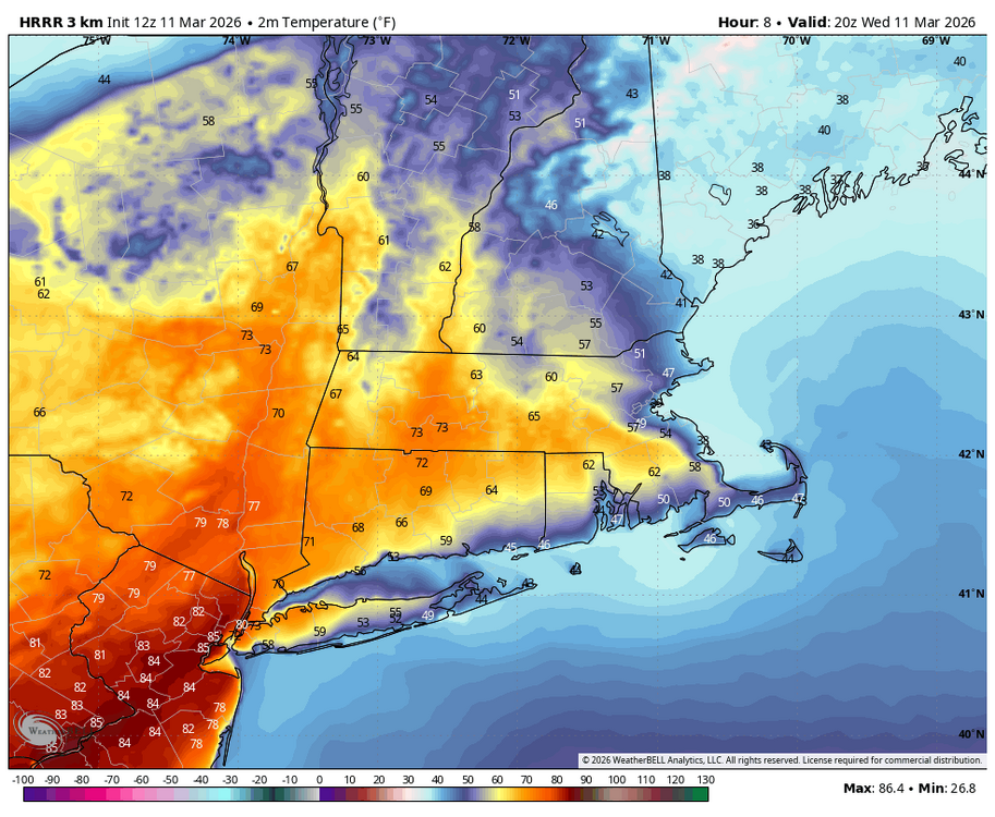
If nothing else I'm looking forward to waking up with temps in the mid 60s and dropping into the 40s by mid day. Don't get that very often. Also the fact we are even talking about the possibility of flakes on the backside of a front with a low end severe threat is pretty crazy.
-
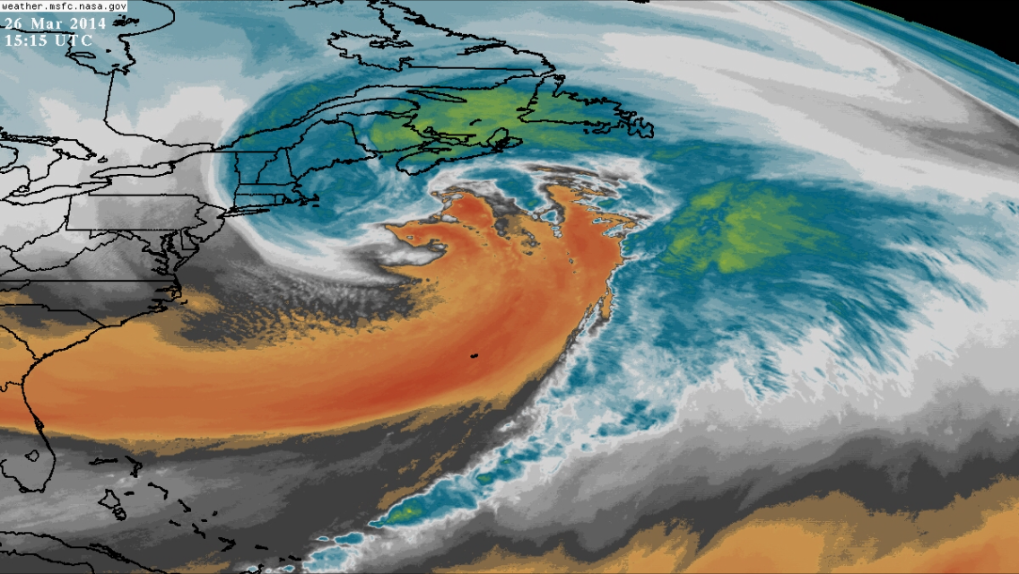
Ya that was a beast..clipped the Cape..but warning for outer Cape iirc Would be nice to get something akin to that to end the month/Winter
-
ya 3/20 still has hope it's 9 days out.. Remember the mega blizzard that hit the cape and especially Nova Scotia around 3/20/14?
-
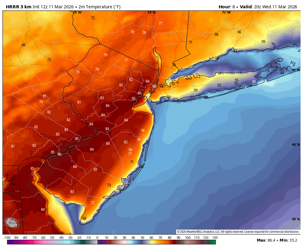
A high of 90 is forecast for this area aided by a steady SW wind pinning the seabreeze and highs have been overperforming a couple of degrees, possibly related to the drought. So, the record high of 87 has a great chance to be broken. Meanwhile, lows in the 30s a couple of days next week will be possible along with highs only in the 50s, which is colder than recent 60s lows! That will make for quite a chilly St. Patrick’s Day parade. Looking forward to that and also a low 40s low well before that on Friday.
-
? What day 15? I said it only takes 1 sw . I mean EPS members do have some solid hits not like it is impossible
.thumb.png.271a1be9dd4da6b7a063003dea3011f1.png)
-
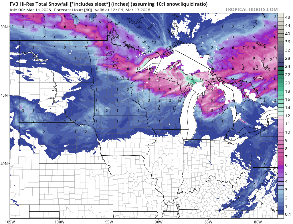
With the tracks of these systems, central Lakes is going to pile up.
-
Yep. Winter ended after the blizzard.
-
Rain shower. Heavy cloud cover, hopefully limits the threat of any severe weather later today.
-
3/20 was another missed opportunity. Have a decent shortwave coming out of the gulf and the ridge just gets pushed east/trough lifts out beforehand.
-
Punch 1 then punch 2. Robust Lake enhanced snows up N for tomorrow night. This time of year, night snows do well. LP is modelled to track SE right under me, and head E thru the Central Lakes.

-

2026 Mid-Atlantic Severe Storm General Discussion
adelphi_sky replied to Kmlwx's topic in Mid Atlantic
Did I read large hail? -
Wild in nyc metro , upper 80s ?

-
If anyone wants or is looking for winter storms, the northern Rockies, northern Plains, and upper-Midwest is where you'll want to be
-
PV is way the hell in nrn Canada.
-
best spot to be with that. Weakens here
-
bumping for new page, this is aweseome
-
Good luck to you guys
-
that happened to our building a few days ago following a warm stretch and quick humid cool off, might have even posted about it lol

.thumb.JPG.418e8a9a2902ae687ec35ff4bc0e038e.JPG)


.png.dc1066fe7b3eae3dbe7368883ca60dba.png)