All Activity
- Past hour
-
nearly 5970meter 500mb closed high pressure near Wausau Wisconsin
-
 @forkyforkTip is speaking your language.
 -
Stayed in the 70's most of the day until sun came out in the late afternoon. High of 82. Picked up a nice soaking .59" today. 2.60" for the month. Everything is greening up again.
-
I've been here 30 years, and late night MCS event surviving from the Midwest and hitting us good have been really rare as far as I can remember. I can think of lots of MCSs falling apart in the morning hours as they arrive in the early morning, but not many delivering the goods in the warm season. (I can think of several cold season events with intense dynamics, but those were more frontal bands than an MCS.) It's just so difficult, because you need elevated instability to compensate for the surface cooling, and we so rarely get the big lapse rates.
- Today
-
Just a trace of rain here today. “Only” 93 today at KSAV, which is actually NN, after a 9 days straight of upper 90s-100.
-
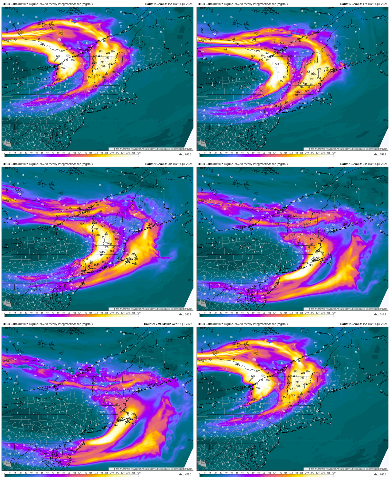
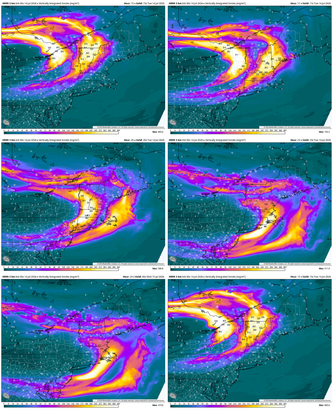
Looks like a smokemaggeddon scenario on Wednesday if the HRRR is right?
-
Wow, this looks quite bad.
-
 At least someone get some video or pictures tomorrow of this up north if anyone can. I’m dyin’ down here
 -
just under 1 inch of rain since late last night
-
That's a shame. I thought you were getting hit much more than you did on Friday and Saturday.
-
Will have to keep a close eye on the path of this wildfire smoke. RAP suggesting some surface smoke on Wednesday, densest near the fires, but extending across the Great Lakes.
-
Looks like maybe more surface smoke on Wednesday if the RAP is correct. Will have to watch out for this, as this could hold back high temperatures some.
-

Big Heat (and storms?) Week into July 4th Weekend
MillvilleWx replied to yoda's topic in Mid Atlantic
This is an amazing animation JT. Thanks for sharing! Insane how hot the HI got in that two day stretch. Widespread 110+ -

2026-2027 Super El Nino
mitchnick replied to Stormchaserchuck1's topic in Weather Forecasting and Discussion
Knock yourself out! Lol https://www.cpc.ncep.noaa.gov/products/CFSv2/cfsv2_fcst_history/ -
Smoke from wildfires in Ontario and Minnesota near the border will make its way into the area tomorrow. This smoke is mostly elevated so it'll make tomorrow's skies more gray than blue. Wednesday's heat potential is significant for coastal locations. Decent WNW wind could allow temps near 100 right to the beaches
-
Just looked at DLH temp records, and looks like top 5 max temps with record/near record high mins. Some other stns should be near record/record max/hmin with shorter records. Stout heatwave for the Northland.
-
Looks like most of it stays aloft tomorrow.
-
Going to be getting real smoky soon.
-
-
You got me beat 2.5” but 1.5” of that came in a 30ish min span. Probably some the heaviest/most consistent rain I’ve seen in quite some time. It’s still just the nerves from Helene but I swear the water just drains and flows differently along the creeks, in my yard, in culverts, etc. Makes every rain a little nerve racking
-
-
 I know what you're talking about but that is different. This is what I am referring too. I think The History Channel had removed the episodes from their page and then get flagged and removed from other accounts because I am always seeing them reposted under different accounts.
 -
6010DM 500MB height on the 0z MSP sounding, which sets a new all-time record.
-
We created this animation / video of the heat indices over the heatwave. 380,000 data points in 5 minutes. https://drive.google.com/file/d/1reTXiqRwfQw1g8udC0H29Po6FsajkJVt/view?usp=sharing
-
Wow. Crazy totals for you in McDowell County. I have right at 1.25 inches. You tripled my total.