All Activity
- Past hour
-
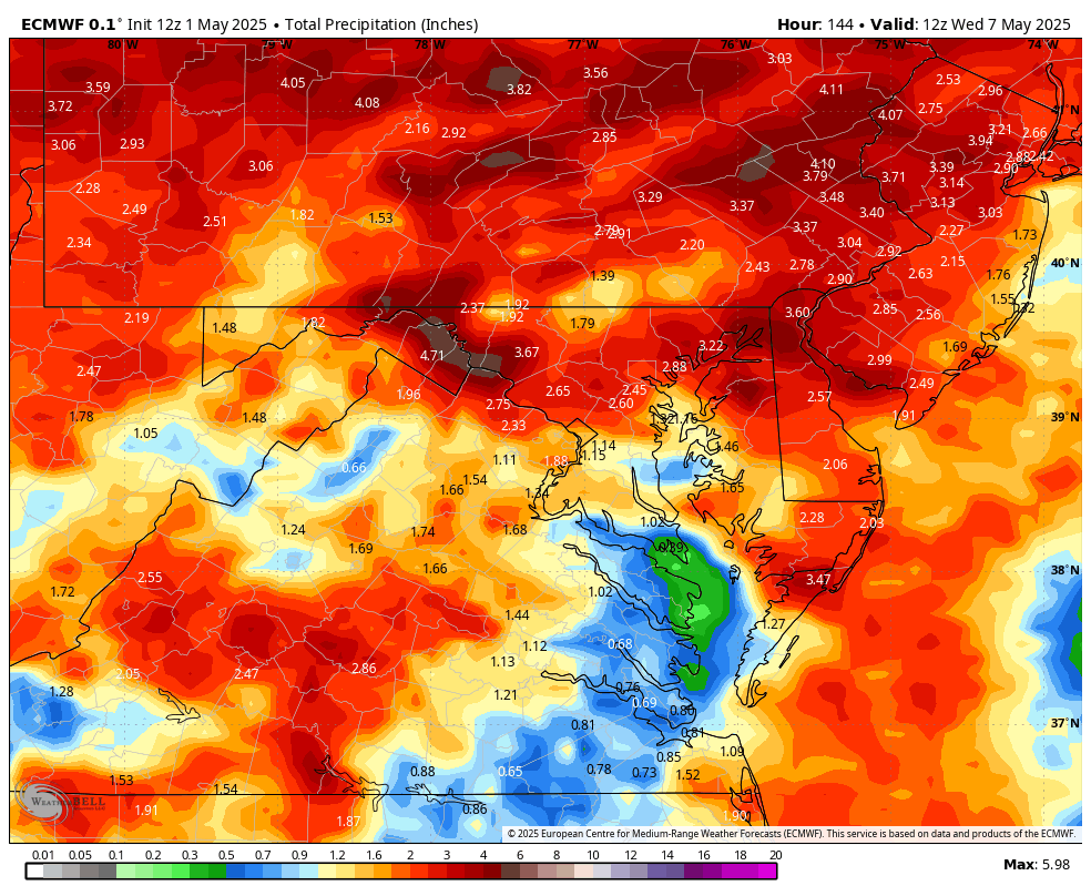
WB 12 Z EURO precip totals through Day 6

-
Vegetation exploding in N ORH county now. always a bit behind the southern/eastern folks
-
-
catching a few popups
-
Close the shades for the next 10 days after today.
-
As bad as posting snowfall maps is, this just totally blows that away
-
I did it last year, the forecast was pretty bleak, but it didn't turn out so bad for people in the earlier waves. They finished basically rain free. Just cloudy and cool. Maybe some brief drizzle. When the rain did come it poured though. Still got soaked on the way home. For those who started later it must of sucked toward the end.
-
Love seeing those 8"s qpf! Hope that holds
-
Dewpoints rapidly heading toward stifling level.
-
not sure why @Damage In Tolland is confused by this post.. still going at hr168
-
Sold! A starving man will accept even a crust of moldy bread
-
Ukie
-
That’s what she said?
-
Maybe one or two weak ones overnight.
-

E PA/NJ/DE Spring 2025 Obs/Discussion
RedSky replied to PhiEaglesfan712's topic in Philadelphia Region
CMC/GFS backed off to 1-2" over the next 7 days concentrating the precipitation north and northeast. A trend? -

Spring 2025 Medium/Long Range Discussion
Spartman replied to Chicago Storm's topic in Lakes/Ohio Valley
Ben Noll considering the lows in next week's Omega Block as bowling balls https://x.com/BenNollWeather/status/1917927485087642085 -
Maybe a couple of bangs/booms in the next 24 hours before SNE “spring” returns?
-
Today's theme seems to be to initially keeping alot of the rain to the N and W
-
I have to look elsewhere for a map with county lines, but that 4-5 inch swath looks like it runs right up the I-81 corridor and into the Poconos.
-
I do have a feeling once this pattern breaks were going to go from cool and Damp to being Hot and muggy..
-
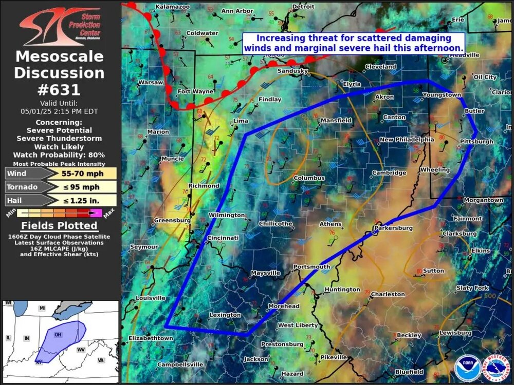
Just driving around yesterday I saw a lot of trees that are about to fall but still hanging on. Hopefully the severe doesn't pan out.
-
-
Hoisting a STEIN for you!
-
The vegetation would love a month's worth of rain in a week, ha.
-

Mountain West Discussion
mayjawintastawm replied to mayjawintastawm's topic in Central/Western States
First week of May always seems to be the only gloomy, wet week of the year here in the Denver Metro (I'll take it!)- 0.40" rain last night and several days more predicted next week.


.thumb.png.e1f898d009b2415a204433df288e6f2a.png)


