All Activity
- Past hour
-
Warmed up nicely once clouds cleared. A tad humid. Got start the fungus treatments on lawn with this weather.
-
Yeah most of the activity firing behind this boundary is staying east in DE.
-
E PA/NJ/DE Summer 2026 Obs/Discussion
Albedoman replied to PhiEaglesfan712's topic in Philadelphia Region
Last chance for a t storm following the ne turnpike. It all or nothing for the LV in the next few hours. -
I hope you get nailed pretty good later. Would be great if the energy /storms near Lancaster, PA settled over you area later this evening.
-
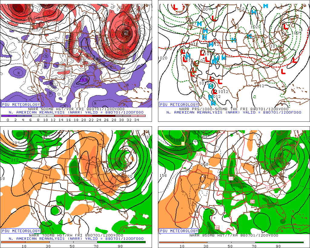
 7/1/1988. 546 low over NNE. 4" of snow on MWN for its largest summer snowfall on record. 34 for a low at Barre Falls MA this day. And this occurred during one of most brutal summers for heat and drought in the CONUS on record. WxWiz is probably wondering..."I bet there were tons of low-topped tstms this day w/ hail!" Yes, there were!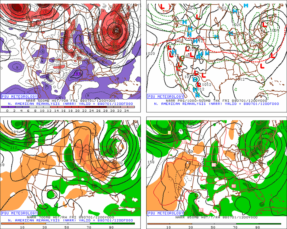
-
I'm sure they will miss my yard lol. 7.3" here for A-M-J and so far in July. Thus the extreme drought.
-
Happy Birthday!!!
-
Carol and Edna were only 10 days apart.
-
1.23 event - monthly total.. 8 days of storms just couldn't get a flush hit...
-
Bad/poor land/water management is a factor, more than it is ever said! It is the same for wildfires. When you have/had a policy to put all fires out as much and quick as possible, that has short-term gain, but the long-term issue is that available fuel builds up over time, and eventually, you end up w/ far worse wildfires. This the primary reason why we have seen so many massive wildfires in the U.S. and Canada in the last 10-15 years. Decades of fire suppression has lead to this situation.
-
Without question storms are certainly firing up. When looking at the hi res radar you can see it perfectly. Pretty cool !
-

E PA/NJ/DE Summer 2026 Obs/Discussion
BBasile replied to PhiEaglesfan712's topic in Philadelphia Region
1.40" today. Puts July at 6.92" of rain. In 11 days... But mostly in 5 days. -
That's b/c what "may" happen these days is all too often promoted as "WILL" happen! Low probably events are teased as a done deal. Also, we don't have many very strong El Ninos in the reliable period of record (since the sat era), so no way have we seen the full variance of what can happen w/ sensible wx in X or Y region.
-
He forget to mention BOS temp is running warm...
-
Yeah I mentioned that outflow boundary in the other thread.
- 1,006 replies
-
- 1
-

-
- severe
- thunderstorms
- (and 7 more)
-
I am not a fan of the US Drought Monitor. I've seen a number of learned mets point out many times how mdt-svr drought conditions can exist when rainfall, soil moisture, reservoir levels, and the CMI/PMI are all solid, but *one* thing will be not good, such as snowpack, and that "ruins" it all. Seen this in WA/OR a number of times the last few years. I have little doubt there are political/social/economic factors that mess w/ the objectivity in some areas of the country. Havig drought conditions (a "problem") is a way to funnel/siphon $$. Declare a drought emergency, and that frees up state/federal funds, as one example. In some regards, it has become racket IMHO.
-

2026 Mid-Atlantic Severe Storm General Discussion
SnowenOutThere replied to Kmlwx's topic in Mid Atlantic
This is the most pity of pity MDs released.- 1,006 replies
-
- 2
-
-

-
- severe
- thunderstorms
- (and 7 more)
-
Interesting boundary from the storms in South Jersey is moving SW through Northern DE into NE MD, causing storms to fire. I just missed one to my South.
-
Happy birthday big guy!
-
I wouldn't say nefarious, just misleading. The psychological part of viewers is well-known, what gets attention, and what does not. That's fine in itself, but as w/ anything, it can be abused or go off the rails. Back in the day, wx at TV stations was largely left alone, and sometimes plain disrespected. I interned at WNEV (now WHDH) in the late 80s, and I can't tell you how many times Harvey Leonard would get so ticked that they would cut the wx segment time 15 or 30 sec. Whenever the newscast needed to be trimmed as it was occurring, it was *always* was w/ the wxcast! This was regardless of what was going on currently or what was in the fcst. Could have a big storm on the way, and time would be still cut. Of course, that all changed after 1993 or so (Bliz of 93 was game changer). It was discovered there was big ratings in wx, and it went rather quickly from not enough time or attention to the opposite extreme. Wx became front and center in the newscast w/ endless teases and hits, and the amount of time an OCM had to actually put together fcst became less and less. The workload increased considerably w/ more complex graphic systems, the Internet, and then later social media. Wall-to-wall coverage for snowstorms or tornado warnings was never a routine thing, at least in the BOS TV market, until the later 90s. It took an exceptional event, like Hurricanes Gloria and Bob, for continuous news coverage for a wx event. Even CoastalWx became keen to this early on. Ask him about, "Nor'easter 95!" The only big snowstorm in the otherwise terrible 1994-95 season! I may sound like a curmudgeon at times, but that's not a inherently bad ting. Just have the experience of how things have changed over time. Change is inevitable, and it is not always bad, but things have become so crazy w/ wx over time, one is going to point things out, and yes, complain at times, esp. when it has to do w/ one's passion and profession!
-
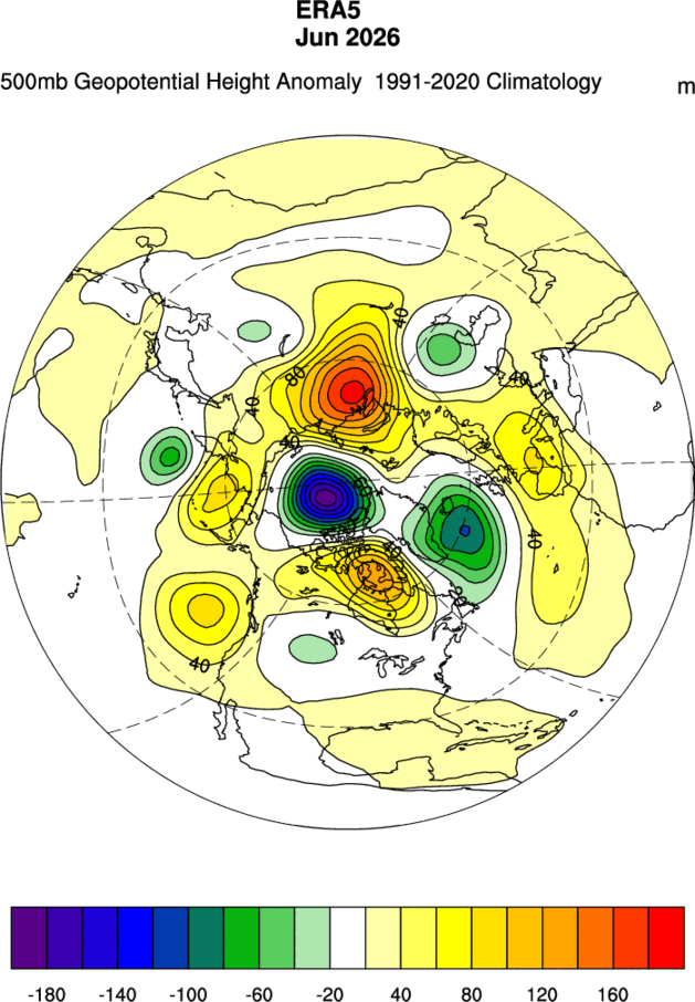
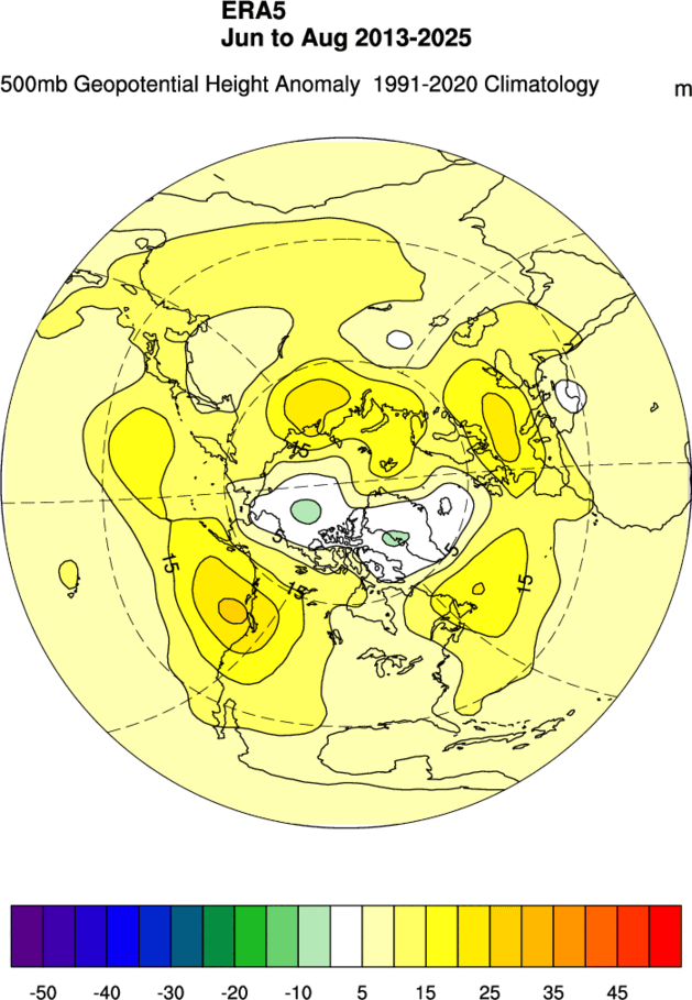
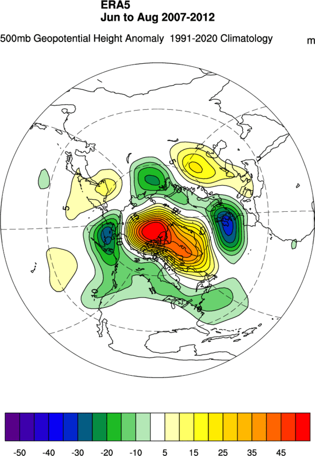
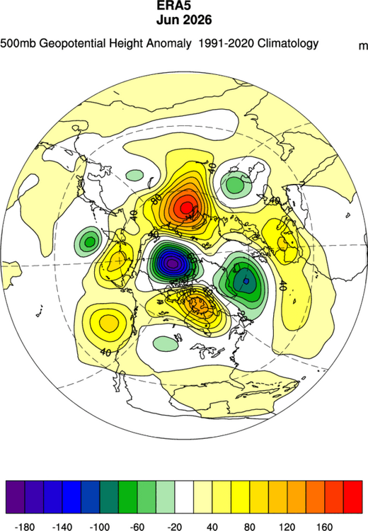
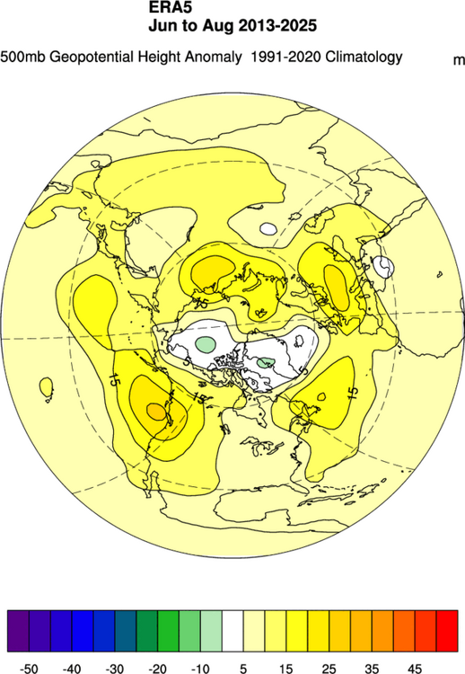
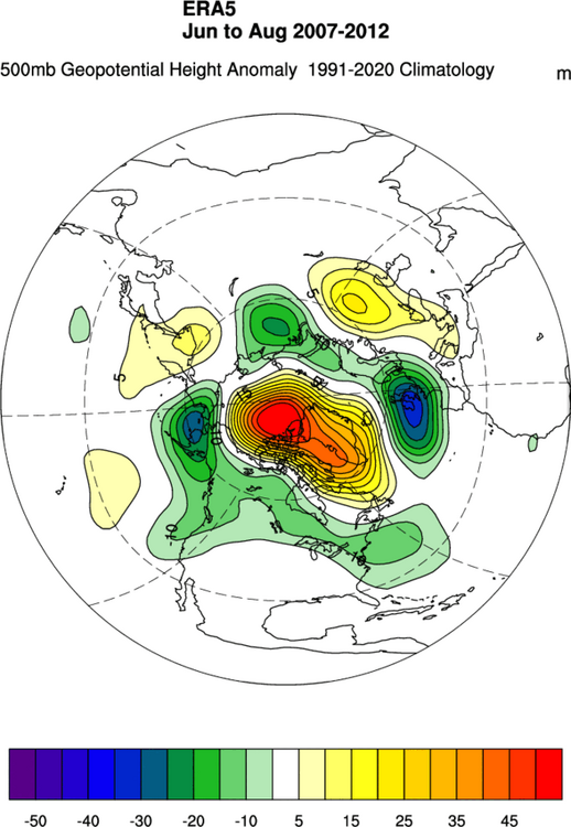
No doubt a cold month for that region. Just not as cold as the DMI ECMWF data. The persistence of low pressure closer to the Pacific side of the Arctic is a function of the big summer dipole reversal since 2013. This weak dipole is the main reason that the 2012 record low has held into the 2020s.
-
not if the 12z Euro verifies.
-

2026 Spring/Summer Mountain Thread
Maggie Valley Steve replied to Buckethead's topic in Southeastern States
Happy Birthday Buckethead! -
Tomorrow will again feature highs mainly in the lower 80s. Temperatures will remain in the lower to middle 80s on Monday before heat begins to push in from the Plains States. Some heat from an impressive heat dome over the Central and Northern Plains could send temperatures into the 90s near mid-month. The potential exists for Newark to approach 100° at the height of the short period of heat. The ENSO Region 1+2 anomaly was +3.4°C and the Region 3.4 anomaly was +1.8°C for the week centered around July 1. For the past six weeks, the ENSO Region 1+2 anomaly has averaged +2.80°C and the ENSO Region 3.4 anomaly has averaged +1.52°C. The ongoing El Niño will continue to strengthen through the summer. The SOI was -30.66 today. The preliminary Arctic Oscillation (AO) was -0.244 today. Based on sensitivity analysis applied to the latest guidance, there is an implied near 64% probability that New York City will have a warmer than normal July (1991-2020 normal). July will likely finish with a mean temperature near 78.8° (1.3° above normal). Supplemental Information: The projected mean would be 2.3° above the 1981-2010 normal monthly value.
- Today
-
It's hot and sunny in my area.