All Activity
- Past hour
-
Looks like it has lightened up over you. Under some heavier returns here with no clearing. The HRRR does have some ZR by 7 PM for whatever it's worth.

-

Pittsburgh/Western PA WINTER ‘25/‘26
SteelCity87 replied to Burghblizz's topic in Upstate New York/Pennsylvania
Definitely a bit strange -
 8.8" 4" in 3 hours
 -

Pittsburgh/Western PA WINTER ‘25/‘26
Ahoff replied to Burghblizz's topic in Upstate New York/Pennsylvania
Pretty decent rates here right now. -

Southern Crippler - Get well soon Jimbo Storm Obs
StantonParkHoya replied to BooneWX's topic in Southeastern States
Looks like the Apps are eating up some of our line . -
 That sleet line has been tactfully hugging the CT shoreline.
 -
Not Tennessee but this ice storm is hellacious.
-

Pittsburgh/Western PA WINTER ‘25/‘26
southpark replied to Burghblizz's topic in Upstate New York/Pennsylvania
Shocked that's all they got in that span. -
You have trains. It's acceptable. My outside decorations are still up just for the snow.
-
That seems high? 11" depth?
-
I honestly don't care what it could have been other than optics of seeing piles of snow. This is just as interesting and impactful. When you have a slope driveway on a hill it kills the 'fun' of clearing cars, pathways and digging out to the street.
-
27.7, around 5" of snow and sleet, maybe a bit more, and now freezing rain, trees starting to look heavy
-

1/24-1/25 Major Winter Storm - S. IL, IN, and OH
HillsdaleMIWeather replied to A-L-E-K's topic in Lakes/Ohio Valley
Gonna end up between 4 and 6 inches here, will definitely take it. It's annoying to see the east coast win again but I'm glad our southern and central ohio peeps finally cashed in a big dog. -
Snow/sleet/freezing rain here currently. "Wintery mix"
-
 Mesoscale Discussion 0064 NWS Storm Prediction Center Norman OK 0302 PM CST Sun Jan 25 2026 Areas affected...northeast Pennsylvania and southeast New York into New England Concerning...Heavy snow Valid 252102Z - 260100Z SUMMARY...Heavy snow will continue from northeast Pennsylvania to New England this afternoon and into the evening. DISCUSSION...Widespread heavy snow is ongoing across the the Northeast and will continue into the evening. Numerous 6 hour snowfall amounts of 8-9 inches have been received from Long Island to Connecticut, supporting a mean snowfall rate of 1.5 inches per hour. Given radar intensity trends, much of this likely came in the last 3-4 hours, suggesting snowfall rates near 2 inches per hour are likely ongoing. Expect these extreme rates to continue for another 3 to 4 hours from Connecticut to Massachusetts as frontogenesis continues northeastward across New England. Thereafter, continued heavy snow around 1 inch per hour may continue through the evening as the deformation band pivots across the region. ..Bentley.. 01/25/2026
 -

January 24-26: Miracle or Mirage OBS Thread!
PrinceFrederickWx replied to Jebman's topic in Mid Atlantic
Up to 5.5” storm total (3.3” snow, 2.2” sleet). Cleared the board as we’ve mostly switched over to freezing rain. (The kids are having a blast; I think they like this more than a pure snowstorm ) -

Southern Crippler - Get well soon Jimbo Storm Obs
kvegas-wx replied to BooneWX's topic in Southeastern States
Can confirm! Going to pick up quickly. -
Pittsburgh/Western PA WINTER ‘25/‘26
SteelCity87 replied to Burghblizz's topic in Upstate New York/Pennsylvania
Damn only .4 the last hour and a half. -
 really warming up.. 11F now up 2F the last hour
 -

2025-2026 Fall/Winter Mountain Thread
AirNelson39 replied to Buckethead's topic in Southeastern States
Looks to be mostly sleet for everyone. The entire Piedmont and foothills area was forecasted to have .5-.75” plus of freezing rain. 95% of that region has had 0 freezing rain. That’s a bust. A good one for people who want power but a bust none the less. The CAD was much stronger and deeper than modeled and precip was much less than modeled. -
We just changed back to that Sneet? Falling to slow to be purely sleet, not really grapel either. Up to 8" (on the deck), almost 6" of snow and the rest sleet and other.
-

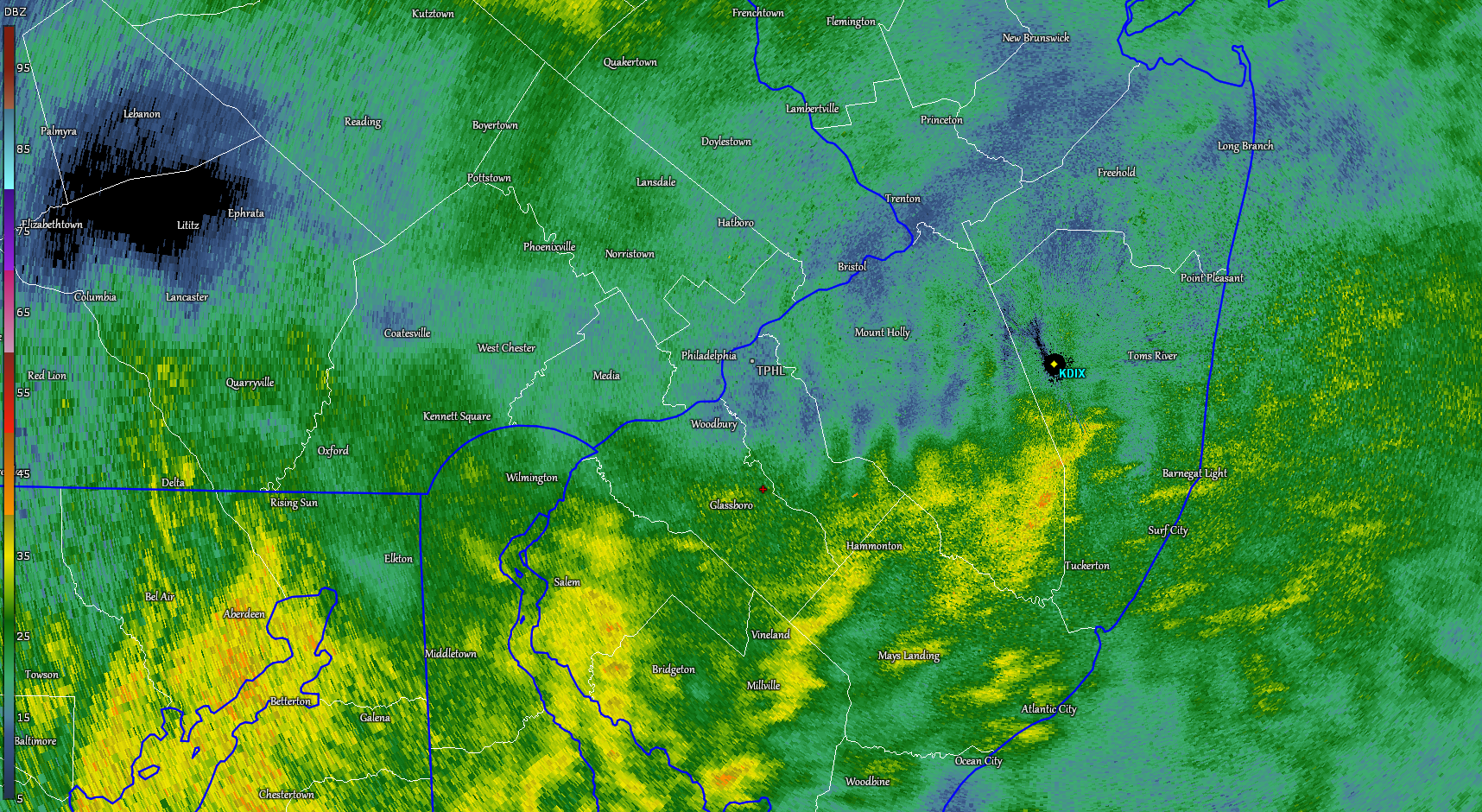
January 25-26 Winter Storm Potential
CoolHandMike replied to Ralph Wiggum's topic in Philadelphia Region
About to be a radar hole over me. Then more sleet. -
I assume the precip type under the actual line is a mix, and below the line is pure sleet? The line is very wide out here and people have snow as well. Maybe that explains the snow/sleet mix rather than pure sleet on the island
-
This was after the change over METAR KISP 251955Z 05015G26KT 3/4SM R06/2800V5000FT SNPL BR VV004 M07/M09 A3012 RMK AO2 PK WND 05029/1943 TWR VIS 1 PLB49 SLP199 SNINCR 2/11 P0012
-
My temp has jumped from 21 to 25 in the last two hours. When the hell is the coastal taking over and temps gonna crash again?