All Activity
- Past hour
-
Due to curiosity about whether or not there likely is a connection between ACE and/or # of CONUS H hits with NE snowfall the following winter, I decided to research NE US AN winters and crunch the #s. I chose a central point with a very long history, NYC. I chose 35” as the breakpoint for AN: Hurr. seasons preceding NYC AN snow (35”+): 44 of last 156 seasons (top 28%): -AN ACE*, AN H hits (2+)**: 2020/17/05/04/03/1995/66/33/16/15/06/1898/96/93/87/80/78 -BN ACE/BN H hits (0 or 1): 2014/13/09/02/1993/77/22/19/1874 -NN ACE/AN H hits: 1960/59/48/47/38/1882/76 -NN ACE/BN H hits: 2000/57/1895/83/72 -AN ACE/BN H hits: 2010/1963/1892 -BN ACE/AN H hits: 1940/13/04 Summary of 44 H seasons preceding AN NYC snow: ACE/# of H hits: 1. AN/AN: 39% (17 seasons) preceding AN snow vs 26% of all H seasons being AN/AN 2. BN/BN: 20% (9) vs 28% 3. NN/AN 16% (7) vs 15% 4. NN/BN 11% (5) vs 13% 5. AN/BN 7% (3) vs 6% 6. BN/AN 7% (3) vs 11% ————— -AN ACE: 45% (20) vs 33% -NN ACE: 27% (12) vs 28% -BN ACE: 27% (12) vs 39% —————— -AN H hits: 61% (27) vs 52% -BN H hits: 39% (17) vs 48% ————— Conclusions -There appears to be a weak but noticeable correlation between ACE and the chance for >35” NYC snow -There appears to be a very weak but noticeable correlation between # of US H hits and the chance for >35” NYC snow -Combining these two factors, a season with both AN ACE and AN H hits, appears to give the strongest chance for >35” NYC snow with it possibly being as much as twice as high as the chance for >35” after BN ACE/BN H hits —————— *ACE norms adjusted for avg ACE of each era **Avg US H hits 1.8 1851-2024 Sources: -NYC snowfall: https://www.weather.gov/wrh/Climate?wfo=okx -ATL ACE: https://en.m.wikipedia.org/wiki/Accumulated_cyclone_energy -# of CONUS H hits: https://www.aoml.noaa.gov/hrd/hurdat/All_U.S._Hurricanes.html @PhiEaglesfan712@snowman19@donsutherland1@BlizzardWx
-
Plenty of rain in Marysville again today. .86 of rain from that Perry County special storm this afternoon. Got another mow in today & the weeds are never ending.
-
Man I do wish my block island vacation was a few weeks earlier, the surf should be awesome next week. Hurricane Lee brought some good waves a few years back but I imagine these will be more significant.
-
 Really? It's just clouds
 -
There will be nothing fun from this
-
Sounds like beer
- Today
-
 Preliminary Scoring Estimates for August 2025 Scoring is based on latest posted anomalies in previous post. These scores are updated whenever the anomalies are updated. FORECASTER ___________DCA_NYC_BOS__east__ORD_ATL_IAH_cent_c/e __ DEN_PHX_SEA__west___TOTALS hudsonvalley21 __________ 34 _ 48 _ 52 __ 134 __ 84 _ 26 _ 80 __ 190 _ 324 __ 86 _ 44 _ 90 __ 220 ____ 544 wxallannj ________________ 34 _ 52 _ 50 __ 136 __ 96 _ 46 _ 70 __ 212 _ 348 __ 84 _ 76 _ 80 __ 240 ____ 588 RJay _____________________40 _ 56 _ 56 __ 152 __ 96 _ 50 _ 90 __ 236 _ 388 __100 _60 _ 90 __ 250 ____ 638 Roger Smith _____________ 40 _ 60 _ 54 __ 154__100 _ 20 _ 54 __ 174 _ 328 __ 74 _ 76 _ 66 __ 216 ____ 544 Yoda _____________________42 _ 68 _ 72 __ 182 __ 74 _ 52 _ 84 __ 210 _ 392 __ 82 _ 52 _ 94 __ 228 ____ 620 wxdude64 _______________46 _ 58 _ 54 __ 158 __ 82 _ 58 _ 98 __ 238 _ 396 __ 78 _ 62 _ 92 __ 232 ____ 628 ____ Consensus _________48 _ 68 _ 70 __ 186 __ 78 _ 52 _ 88 __ 218 _ 404 __ 88 _ 58 _ 96 __ 242 ____ 646 Scotty Lightning _________ 50 _ 70 _ 80 __ 200 __80 _ 40 _ 70 __ 190 _ 390 __ 70 _ 50 _ 80 __ 200 ____ 590 so_whats_happening ____ 50 _ 74 _ 70 __ 194 __ 78 _ 58 _100 __ 236 _ 430 __ 90 _ 56 _ 98 __ 244 ____ 674 Tom ______________________58 _ 80 _ 82 __ 220 __ 64 _ 52 _ 88 __ 204 _ 424 __ 84 _ 46 _ 98 __ 228 ____ 652 DonSutherland1 __________64 _ 80 _ 78 __ 222 __ 68 _ 66 _ 94 __ 228 _ 450 __ 92 _ 62 _ 86 __ 240 ____ 690 StormchaserChuck1 _____ 66 _ 82 _ 74 __ 222 __ 68 _ 68 _ 94 __ 230 _ 452 __100 _66 _ 84 __ 250 ____ 702 ____ Normal ______________70 _ 90 _ 90 __ 250 __ 60 _ 70 _ 90 __ 220 _ 470 __ 60 _ 20 _ 70 __ 150 ____ 620 RodneyS _________________98 _ 84 _ 98 __ 280 __ 78 _100 _92 __ 270 _ 550 __ 96 _ 50 _ 92 __ 238 ____ 788 =============== ____ Persistence __________ 42 _ 50 _ 52 __ 144 __ 98 _ 02 _ 86 __ 186 _ 330 __ 60 _ 48 _ 86 __ 194 ____ 524 ______________ EXTREME FORECAST REPORT DCA, NYC, BOS, ATL __ All currently would be wins for RodneyS with lowest forecasts, Normal also wins for NYC, ORD would be a loss for wxallannj (+2.2) and a win for Roger Smith (+2.0) but at +2.1 it's a tie, and at +1.9 or lower, not an extreme forecast. PHX would be a win for tied highest forecasts of wxallannj and Roger Smith (+2.8). IAH, DEN and SEA would not be extreme forecast qualifiers. ======================================== (actual forecasts) FORECASTER ____________ DCA _NYC _BOS ___ ORD _ATL _IAH ____ DEN _PHX _SEA hudsonvalley21 __________ +1.8 _ +2.1 _ +1.9 ___+1.3 _ +2.2 _ +1.5 ___+1.3 _ +1.2 _ +1.0 wxallannj ________________ +1.8 _ +1.9 _ +2.0 __ +2.2 _ +1.2 _ +2.0 __ +2.8 _+2.8 _ +0.5 RJay ____________________ +1.5 _ +1.7 _ +1.7 ___ +1.8 _ +1.0 _ +1.0 ___ +2.0 _+2.0 _+2.0 Roger Smith _____________ +1.5 _ +1.5 _ +1.8 __ +2.0 _ +2.5 _ +2.8 __ +3.3 _ +2.8 _+3.2 Yoda _____________________+1.4 __+1.1 __+0.9 __ +0.7 _+0.9 _+1.3 ___ +1.1 _ +1.6 _ +1.8 wxdude64 _______________+1.2 _ +1.6 _ +1.8 ___+1.1 __+0.6 _ +0.4 __ +0.9 _ +2.1 _ +1.9 ____ Consensus _________ +1.1 __+1.1 _ +1.0 __ +0.9 _+0.9 _ +1.1 ___ +1.4 _ +1.9 _ +1.7 Scotty Lightning _________ +1.0 _ +1.0 _ +0.5 __ +1.0 _ +1.5 _ +2.0 __ +0.5 _ +1.5 _ +0.5 so_whats_happening ____ +1.0 _ +0.8 _ +1.0 __ +0.9 _ +0.6 _+0.5 __ +1.5 _ +1.8 _ +1.6 Tom ______________________+0.6 _+0.5 _ +0.4 __ +0.2 _ +0.9 _+1.1 ___ +1.2 _ +1.3 _+1.4 DonSutherland1 __________+0.3 _ +0.5 _ +0.6 __ +0.4 _+0.2 _+0.2 __ +1.6 _+2.1 _ +2.2 StormchaserChuck1 _____ +0.2 _ +0.4 _ +0.8 __ +0.4 _+0.1 _ +0.2 __ +2.0 _+2.3 _+2.3 ____ Normal _______________ 0.0 __ 0.0 __ 0.0 ___ 0.0 __ 0.0 __ 0.0 ____ 0.0 __ 0.0 __ 0.0 RodneyS _________________ -1.4 _ +0.3 _ -0.6 __ +0.9 _ -1.5 _ +0.1 ___ +1.8 _ +1.5 _ +1.1 =============== ____ Persistence __________ +1.4 _+2.0 _+1.9 __ +2.1 _ +3.4 _ +1.2 ____ 0.0 _ +1.4 _ +0.8 ______________
 -
Two clear trends in the guidance: 1) the timing of the storm chances for most is moving up from overnight Sunday to Sunday late afternoon / early evening 2) with northeast flow and clouds, Monday may not get to 80 degrees for most. Could even end up well below 80.
-
SERCC's Climate Perspectives suggests Chicago would move into a tie for hottest season (through August 20) with the current forecast. Unfortunately, the last 7-10 days of the month looks cooler on the whole.
-

Hurricane Erin: 140 MPH - 937mb - WNW @ 14
wthrmn654 replied to BarryStantonGBP's topic in Tropical Headquarters
Of note looks like all the hurricane models took a big shift west as well -
The Orioles went an impressive 0/14 with RISP tonight. I am genuinely impressed with that kind of futility. In other news, Ravens looked pretty good with the back ups tonight. Ran 79 plays to Dallas 49. Pretty much dominated for 98% of that contest. Come on September!
-

Hurricane Erin: 140 MPH - 937mb - WNW @ 14
Wannabehippie replied to BarryStantonGBP's topic in Tropical Headquarters
11:00 PM AST Sat Aug 16 Location: 20.3°N 65.1°W Moving: WNW at 14 mph Min pressure: 937 mb Max sustained: 140 mph -
Hurricane Erin: 140 MPH - 937mb - WNW @ 14
wthrmn654 replied to BarryStantonGBP's topic in Tropical Headquarters
Nhc track is to far east now -
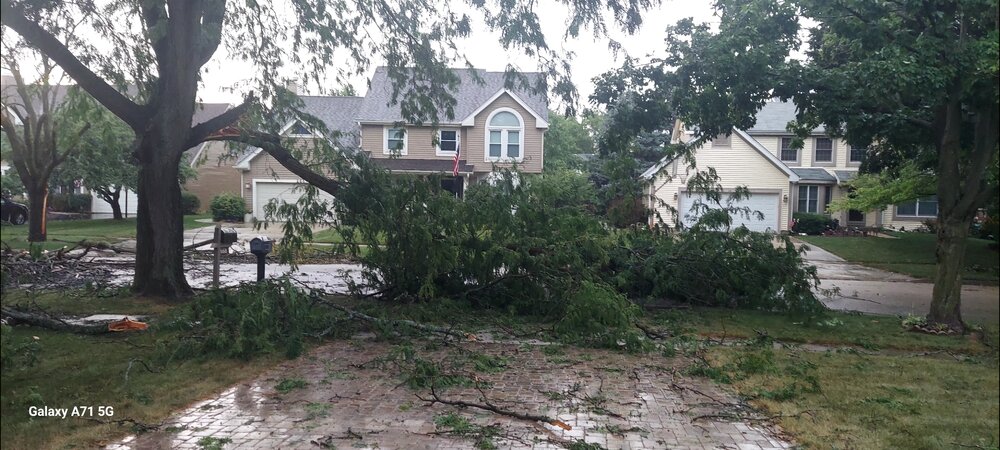
Noticed a lot of leaves down this evening as we went for a drive. Sad stuff.
-

2025 Short Range Severe Weather Discussion
Cary67 replied to Chicago Storm's topic in Lakes/Ohio Valley
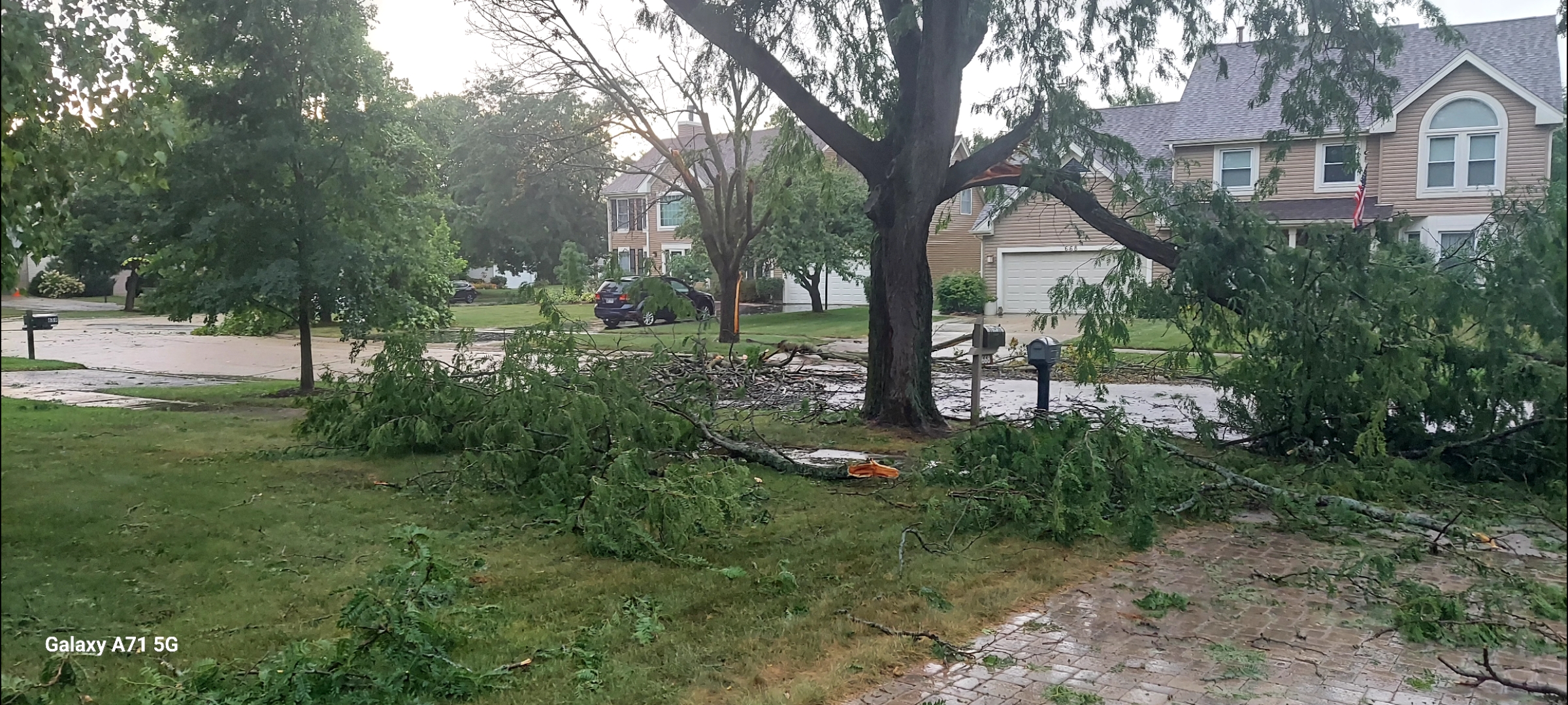
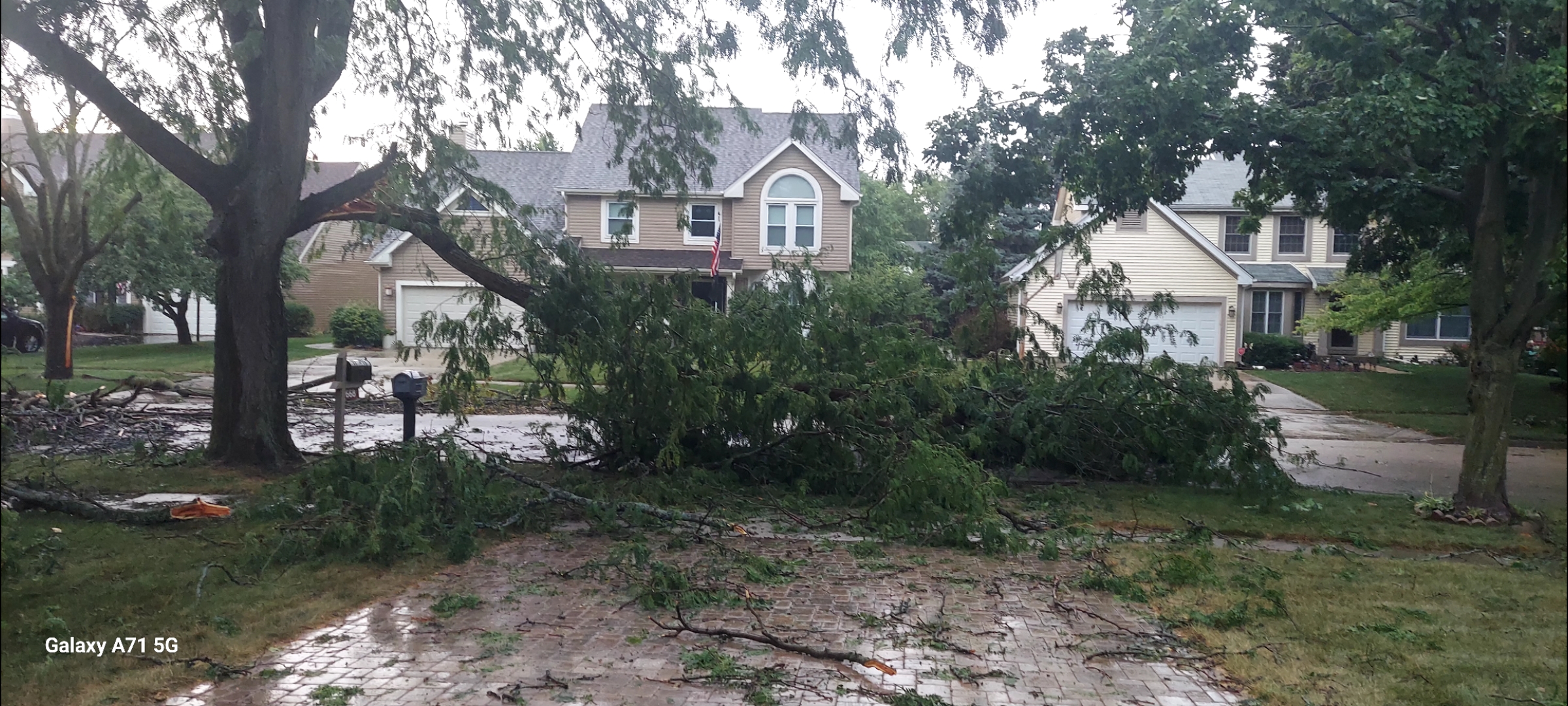
Kaboom. No power for 4 hrs.Needed the rain though.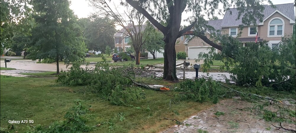
-
The gauge in my yard was .80” so believable.
-
Persistent onshore S/SE wind
-
Hit 94 here today, with max dewpoint of 81. Luckily will get a decent break from high humidity next week.
-
 Highs: PHL: 90 TTN: 89 TEB: 87 New Brnswck: 87 EWR: 84 LGA: 84 NYC: 84 ACY: 83 ISP: 82 BLM: 82 JFK: 81
 -

2025 Short Range Severe Weather Discussion
cyclone77 replied to Chicago Storm's topic in Lakes/Ohio Valley
'Heat' lightning pretty frequent in the northern sky here. -

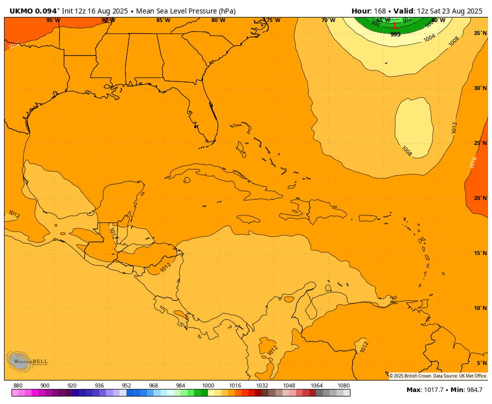
NEW DISTURBANCE: Central Tropical Atlantic (0/20)
GaWx replied to BarryStantonGBP's topic in Tropical Headquarters
Followup to the above 12Z UKMET post regarding the new MDR AOI: I just looked at the last 4 UKMET runs and discovered that the reason the latest run recurves this AOI into Erin is because Erin is further SW due to a further W recurve and thus doesn’t exit until a couple of days later than yesterday’s runs:UKMET progs for 0Z 8/22:1) 0Z 8/15 run at 168 hrs:Erin 954 mb at 38N, 59W after recurve at 70WAOI 1011 mb at 20N, 61W, is 1,250 miles to the S2) 12Z 8/15 run at 156 hrs:Erin 949 mb at 42N, 57W after recurve at 70WAOI 1006 mb at 18N, 62W, is 1,700 miles to the SSW3) 0Z 8/16 run at 144 hrs:Erin 962 mb at 37N, 66W after recurve at 73WAOI 1007 mb at 16N, 59W, is 1,500 miles to the SSE4) 12Z 8/16 run at 132 hrs:Erin 958 mb at 35N, 71W after recurve at 74WAOI 1006 mb at 20N, 57W, is 1,350 miles to the SEmoving NW to the S of retreating H5 ridgeConclusion: It isn’t just about how fast the AOI moves W and develops, but also and possibly more crucially it is about how far W Erin recurves. The further W Erin recurves, the longer it will take for her to exit. The later the exit, the better chance the AOI would have to recurve before reaching the Conus.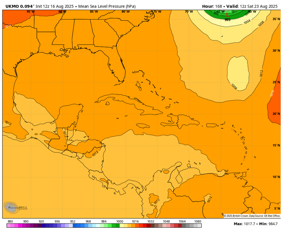
-
I think given today's events, it's prudent to continue to keep an eye on this. It's still too early for either camp to declare victory, imo Sent from my Pixel 9 Pro XL using Tapatalk
-

2025-2026 ENSO
PhiEaglesfan712 replied to 40/70 Benchmark's topic in Weather Forecasting and Discussion
Yes, but most places in the mid-Atlantic/northeast should have followed a similar pattern (especially with temperature). -

2025 Short Range Severe Weather Discussion
sbnwx85 replied to Chicago Storm's topic in Lakes/Ohio Valley
Watched two outflow boundaries collide just to my south on radar. Nice line of storms developed with, as @Jackstraw described, constant lightning. -
Twitter is a cesspool of bots but this is amazing eyewall of Erin footage https://x.com/wxnb_/status/1956827623062962483?s=46&t=8XFCjgbF1qQWLVKslle9tw


.thumb.png.4150b06c63a21f61052e47a612bf1818.png)