All Activity
- Past hour
-

2026-2027 Super El Nino
Stormchaserchuck1 replied to Stormchaserchuck1's topic in Weather Forecasting and Discussion
^You were right about the lagged warming after the SOI. -
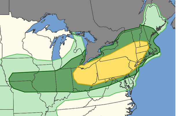
Tomorrow evening could be interesting near the northern parts of the LWX CWA
-
-
ahhh right...the Oct 79 was left moving
-

2026-2027 Super El Nino
GaWx replied to Stormchaserchuck1's topic in Weather Forecasting and Discussion
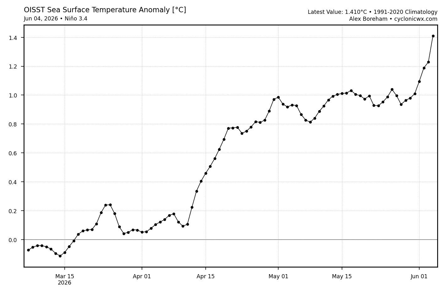
Wow! The latest update for OISST (June 4th) has a massive warming for one day: 0.189C! That’s the strongest one day warming since way back on March 6th! The last 4 days have warmed a hair over 0.4C or a whopping 0.1C/day! That’s the fastest 4 day warming on this entire chart, even exceeding the ~0.36C of April 11th-15th. See far right side of the image below. The strong -SOI is doing its magic on its typically couple of week delayed basis vs when the strong negative strong started. This means the 6/5/26 RONI equivalent daily is already up to the +0.8 to +0.9 range! Implications for Monday’s weekly 3.4 update: at the very least an increase of 0.2C to 0.7C relative 3.4. There’s a good shot at an increase of 0.3 to 0.8 relative 3.4 if this continues to rise on the next 2 days’ updates: Check out today’s and last 4 days’ warming!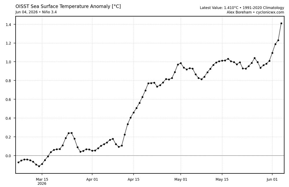
-
has anyone else noticed an absence of mosquitos
-
Maybe biased a little extreme, but the Euro is legit seasonal model.
-
so far 95.5
-

Pittsburgh PA Summer 2026 Thread
TheClimateChanger replied to TheClimateChanger's topic in Upstate New York/Pennsylvania
I didn't see anyone mention, but it was an incredible spring here for western Pennsylvania standards. The average high of 65.7°F ranked as 4th warmest on record for meteorological spring behind only 2012, 2024 & 1921. Incredibly, each of the last three springs are among the 8th warmest (by average daily high) in the entire threaded record! Wow! -
Pittsburgh PA Summer 2026 Thread
TheClimateChanger replied to TheClimateChanger's topic in Upstate New York/Pennsylvania
After a relatively cooler start to the month, it looks like temperatures should be decidedly warmer than normal for much of the next two weeks. Here are the European ensemble means and spreads for highs & lows at Allegheny County Airport. Looks like great pool weather coming up. -

E PA/NJ/DE Spring 2026 Obs/Discussion
Hurricane Agnes replied to PhiEaglesfan712's topic in Philadelphia Region
Tapped 90 for the first time this month about 45 minutes ago, my 5th 90 or above temp for the year so far. Just missed it yesterday when I didn't get past 89. After a 65 low this morning, it's currently sunny and 89 with dp 60. -
Summer is here!
-
You mean "right-moving!"
-
84° , which is hot for here.
-
I would say the more positive the better, main effect of PDO is PNA/EPO which the stronger they go, they stronger our troughs are here on the East Coast. The PDO has steep incline to Winter effect the further in the year you go. Here's the lagged correlation: So Fall PDO is like 2x more important than Spring PDO.
-
87F with a slight breeze. My house is boiling. Had the ac cranking this morning when I got home from work turned it off huge mistake. Now its struggling to get cool in here with 13 foot ceilings. 78 in the house.
-

2026-2027 Super El Nino
LakePaste25 replied to Stormchaserchuck1's topic in Weather Forecasting and Discussion
Latest Euro seasonal gets the enhanced coastal precipitation going as early as September.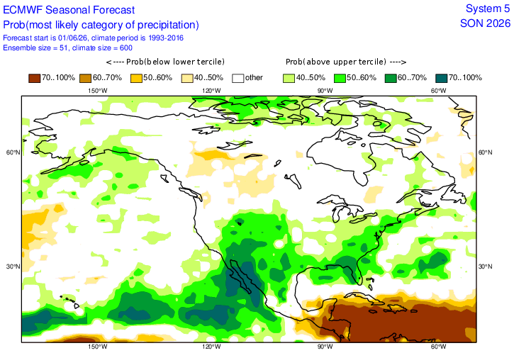
- Today
-

-
It is blazing out there but at least the dewpoint isn't in the 70's.
-

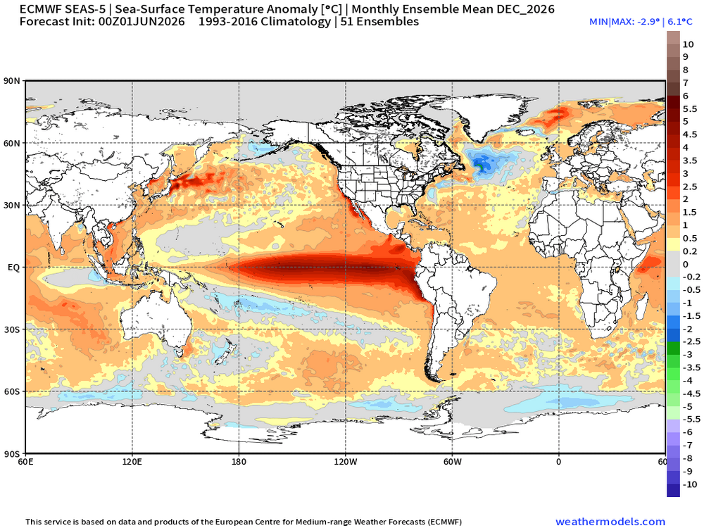
2026-2027 Super El Nino
bluewave replied to Stormchaserchuck1's topic in Weather Forecasting and Discussion
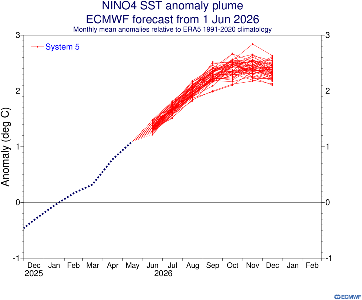
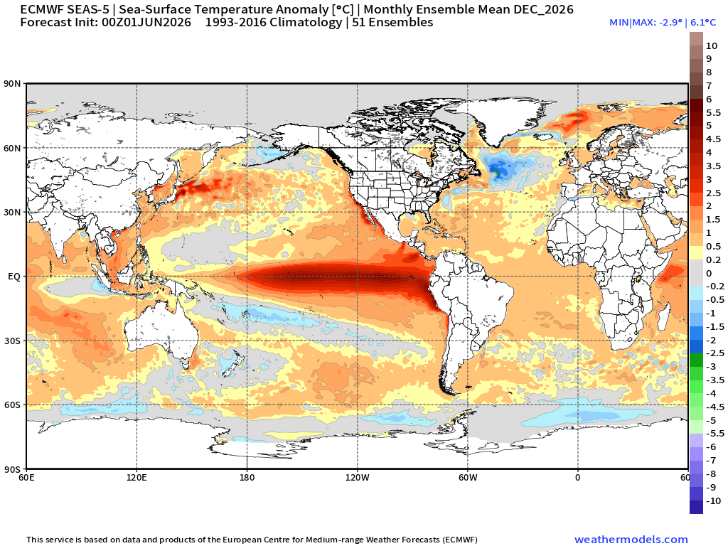
The core of the 30C+ SSTs will probably shift over closer to MJO 7 and Nino 4 as the current forecast would surpass even 2015-2016 and 2023-2024 in those locations. The Euro has Nino 4 exceeding +2.0 which would be a first if it verifies. The previous Nino 4 record was 30.21C and +1.51 back in November 2023. Perhaps some areas could approach +31.0C. Even Nino 3.4 could get close to +30.0 C like in 2015-2016. The Euro has the warm pool east of Japan continuing. The IOD peaks in October and the SSTs near the Maritime Continent begin to rebound by December. So an historic and extensive area of extreme SSTs from the WPAC into the ENSO regions being forecast. https://www.cpc.ncep.noaa.gov/data/indices/ersst5.nino.mth.91-20.ascii 2015 11 23.93 2.28 27.95 2.84 30.13 1.44 2023 11 23.73 2.07 27.20 2.10 30.21 1.51
-
Cell in EC MN moving towards Hinckley has a strong hail sig. Complex moving into N WI. Looks like a miss S for me.
-
Looks like tonight may miss south too lol. Guess we'll try again on Sunday.
-

2026-2027 Super El Nino
csnavywx replied to Stormchaserchuck1's topic in Weather Forecasting and Discussion
We ain't getting a CP or "basin wide" event. Too much off-equator WWB activity, which focuses WWV onto the equator via Eckman transport and causes EKWs to break and surface later. If you want a CP/basin wide or w/e, you def want your bursts narrowly focused with some trade wind resistance like we had in the '99-'22 era. There was arguably a bit of that left in the '23/'24 event but we've had no issues killing off the trades, even well away from the equator. This is *much closer* to the '72-'98 environment in that respect. I can't be the only one who remembers how tough it was to kill off the trades even in the '15/'16 event. It languished for a while in the summer because of it and we had two false starts ('12 and '14) before that one took off. We are miles away from that. -
2026-2027 Super El Nino
GaWx replied to Stormchaserchuck1's topic in Weather Forecasting and Discussion
Indeed, Don, the Euro’s June prog has the strongest (“monster” as you said) on record. And I agree it’s looking E based. But it’s not currently looking nearly as E based as 97-8 based on peak fall/winter differences between 1+2 and 3.4/4 per the latest Euro. And it’s not even looking as E based as 1982-3 per these same differences. -
Currently 90F here, after an overnite low of 59F.