All Activity
- Past hour
-
Exactly a half inch here. Good enough. Was already out of the drought, but was beginning to get dry again. Maybe another quarter inch or so over the next couple days with scattered showers.
-
Has anyone else noticed how many helicopters are on the maples this summer? I have never, ever seen anything like this on them around here. This will be a disaster the next few weeks as they come down . Wonder why so many this summer .
-
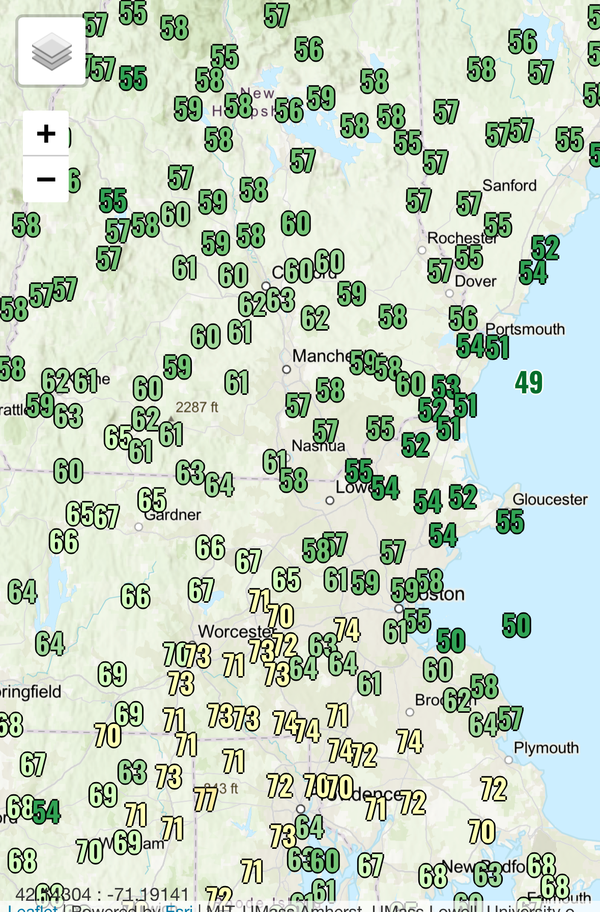
79.4 for the high. BDF came through when I was in Plymouth. Now 56 lol.
-
lookin good

-
Beats my 55.5°
-

E PA/NJ/DE Spring 2025 Obs/Discussion
Voyager replied to PhiEaglesfan712's topic in Philadelphia Region
And to your northwest. I've got 1.95" in the gauge since midnight up here in Tamaqua. -
A little premature. Don't we usually at least wait until we are all sick of the summer heat and humidity(end of June) before starting this thread?
-
Backdoor on a day like today?!? Whole different world down there.
-

E PA/NJ/DE Spring 2025 Obs/Discussion
Hurricane Agnes replied to PhiEaglesfan712's topic in Philadelphia Region
Well another little scattered shower earlier this afternoon added 0.11" to the bucket for a total of 0.22" for the day so far and a 2-day event total of 0.89". The high so far today was 71 just before 11 am but that has dropped down since. It's currently overcast and muggy with temp 67 and dp 65. -
NJ and NYS mesonrtd have about 2.3” near High Point NJ and Port Jervis NY. Am remote so can’t verify but am sure SR23 washout is legit. Don’t know how serious.
-
While both of those are garunteed to happen at some point, Yellowstone could be hundreds of thousands of years and a extinction level meteor impact millions of years.
-
Dried up enough to get a mow in. Gorgeous afternoon. Saw Thunderbolts earlier...eh
-
Report of a road washout in Sussex county NJ where fall rates were nearly 3.5 per hour a couple hours ago. SR23 out of high point state park. Saw other mPING reps of flooding W Sussex county. While my AWN reads high. At VA least 1.3” past 24
-
0.76" for me so far during this event. (Herndon, VA)
-
1.56 heading into tonight...I'd love to sneak in 2" out of this
-
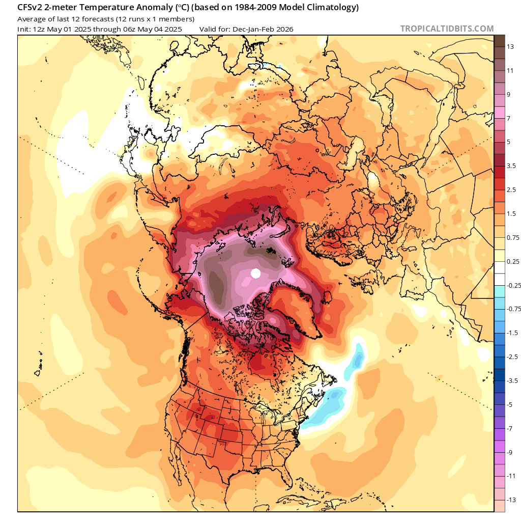
I'm definitely not an expert in your climate. It's actually confusing to me. It's simultaneously too snowy and not snowy enough for an outsider to understand, if that makes sense. I don't see nyc as having a true wintry climate, but I also don't see them as being a 1-snow-a-year climate like the south. It's interesting to note that if you compare the 1875-1900 period to the 2000-2025 period, east coast cities are generally 3.5-5° warmer in 2000-25 than 1875-1900, while lower Great Lakes cities are generally 0.5-2° warmer. Clearly winter has warmed more on the east coast. That's likely a contributing factor to the feast/famine snowfall and why many of your largest snowstorms have occurred this century. While I'm no fan of warmer winters, I've noticed a trend locally that's encouraging- more dynamic snowstorms during warmer winters than there used to be. Always prefer colder winters, but it would be nice to have that in the back pocket. But I REALLY hesitate to place any bets on future decades, and that's what my main disagreement with you is. You may be wrong you may be right....but we won't know for a long while.
-
Kinda glad to be where I am after seeing that airmass moving into ENE.
-
80 and sunny at msp. First official 80 of 2025
-
The backdoor of consequence rarely comes lubed. in the backyard in a loin cloth about to grill, and it dropped 20 degrees.
-

E PA/NJ/DE Spring 2025 Obs/Discussion
RedSky replied to PhiEaglesfan712's topic in Philadelphia Region
GFS highs in the 40's next Friday -
You’ve been in there. They don’t all show unless you zoom in. I may need to update some…it’s been a couple years.
-
one day yellowstone will erupt or a asteroid will hit earth that will reduce the population.
-
E PA/NJ/DE Spring 2025 Obs/Discussion
RedSky replied to PhiEaglesfan712's topic in Philadelphia Region
2.20" Today's rain has missed to the east -
steady rain has commenced here
- Today
-
Tomorrow will be rainy and cool. Temperatures will likely top out in the lower and middle 60s. Additional rain is likely into Wednesday before a cooler and drier air mass moves into the region. The coolest air this month could arrive to end the week. It is possible that New York City could see a low temperature near or just below 50° on Friday or Saturday. The ENSO Region 1+2 anomaly was -0.3°C and the Region 3.4 anomaly was 0.0°C for the week centered around April 23. For the past six weeks, the ENSO Region 1+2 anomaly has averaged +0.82°C and the ENSO Region 3.4 anomaly has averaged -0.05°C. Neutral ENSO conditions will likely continue through at least early summer. Early indications are that summer 2025 will be warmer than normal in the New York City and Philadelphia areas. The potential exists for a much warmer than normal summer (more than 1° above normal). The SOI was -2.97 today. The preliminary Arctic Oscillation (AO) was +0.650 today.