All Activity
- Past hour
-

Central PA Summer 2026 Discussion/Obs Thread
Itstrainingtime replied to Voyager's topic in Upstate New York/Pennsylvania
Mine never got above 93. Well short of where models had it. -
i appreciate your perspective, and allow me to suggest this: so much of this isn't really "debate" at all, it's just disagreement and arguing for that sake. spectacle. Reasonable people can disagree on interpretation, but blowhards are rarely reasonable, and often are pushing an agenda, or are paid shills. Our collective understanding of what we are doing to our environment needs to be led by curiosity and a desire to understand. Scientific debate founded in honest curiosity doesn't have an agenda and doesn't seek an audience, or sponsor.
-

Central PA Summer 2026 Discussion/Obs Thread
Superstorm replied to Voyager's topic in Upstate New York/Pennsylvania
Only got to upper 80s. Not sure what heat index got to. . -
Yeah it’s 92 here now too. That heat escalated quickly IMBY
-

Septorcher 2026 Discussion - Endless Summer
JACKASS replied to Damage In Tolland's topic in New England
Been there! Still get the floaters, but luckily (with age) the headaches are just annoying and no longer debilitating. Broke my back twice while in my twenties, along with other multiple broken bones (age makes these more difficult to deal with now). Hope ya feel better tomorrow!! -
I see golf ball sized hail and winds to 70mph in the warnings ETA - LSRs coming out with numerous trees, power lines, and power poles downed
-

2026 Mid-Atlantic Severe Storm General Discussion
Eskimo Joe replied to Kmlwx's topic in Mid Atlantic
Cloud top to 55,000 ft on that cell just NW of Pittsburgh -

Septorcher 2026 Discussion - Endless Summer
dendrite replied to Damage In Tolland's topic in New England
Back spasms and migraine today. I’m like a Larry Bird/Wes Welker love child today…laying on my back in a dark room. -

2026 Mid-Atlantic Severe Storm General Discussion
batmanbrad replied to Kmlwx's topic in Mid Atlantic
question for the expert community - that line of storms is heading over Lake Erie - will the lake itself have any influence (in either direction) over the line's strength and/or motion? We all know what those lakes can do in winter... -
Temp forecast didn't quite work out here today. Low 90s forecast, low 80s reality. Humidity worked out. Sultry out there.
-
Septorcher 2026 Discussion - Endless Summer
JACKASS replied to Damage In Tolland's topic in New England
Damn, you need Pantera too?! So be it! -
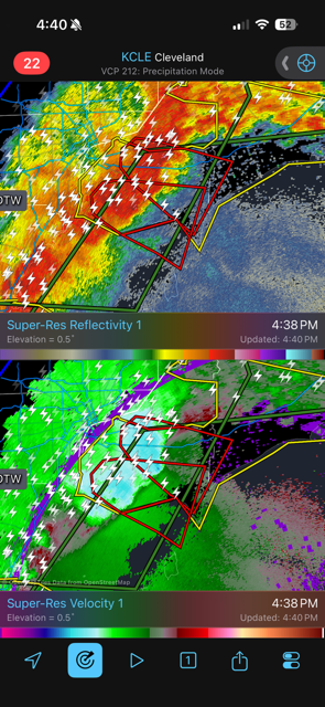
Yeah the Detroit and Cleveland WFO radars are sampling 90+mph winds at like 4-5kft
-

Septorcher 2026 Discussion - Endless Summer
weatherwiz replied to Damage In Tolland's topic in New England
I think I'm ready for fall...more so because I'm pumped NFL season starts Wednesday and NHL in 3.5 weeks. Once you get these cloudy days and it makes the earlier sunsets super apparent and dealing with the darker earlier mornings that's a sign to wave the white flag on summer and start moving onto the next season. -
87/70 currently.
-
Those storms in eastern Michigan mean business.
-
Septorcher 2026 Discussion - Endless Summer
JACKASS replied to Damage In Tolland's topic in New England
Max volume to scare the sky! LOL -
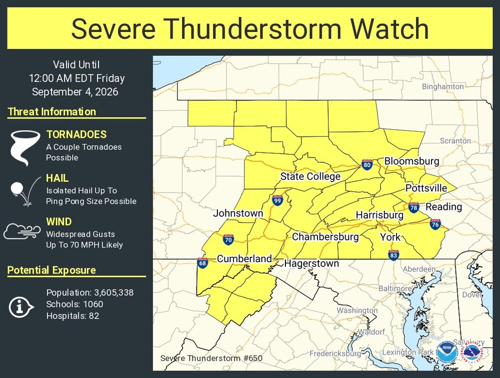
https://www.spc.noaa.gov/products/watch/ww0650.html URGENT - IMMEDIATE BROADCAST REQUESTED Severe Thunderstorm Watch Number 650 NWS Storm Prediction Center Norman OK 435 PM EDT Thu Sep 3 2026 The NWS Storm Prediction Center has issued a * Severe Thunderstorm Watch for portions of Western Maryland Western and Central Pennsylvania Eastern West Virginia * Effective this Thursday afternoon from 435 PM until Midnight EDT. * Primary threats include... Widespread damaging wind gusts to 70 mph likely Isolated large hail events to 1.5 inches in diameter possible A tornado or two possible SUMMARY...Multiple rounds of severe storm clusters are expected to move into the region from the northwest and impact the region this evening, with wind damage as the most common hazard.
-

E PA/NJ/DE Autumn 2026 Obs/Discussion
GaWx replied to PhiEaglesfan712's topic in Philadelphia Region
Oops, I forgot to break down by months. I think Dec/Feb will have the best chance to have the warmest/coldest anomalies amomg DJF, which is consistent with strong Nino analogs and model consensus for the E US. In the SE when we’ve had 1-2 big winter storms, they’ve tended to be mainly between the 2nd half of Jan and March. A major exception was the SE major winter storm of early Dec of 1896! So, of course, one never knows. @Newman -
2026 Mid-Atlantic Severe Storm General Discussion
Eskimo Joe replied to Kmlwx's topic in Mid Atlantic
Time to chase the Allegheny Front -
Well let’s see what happens
-
Cc drop as that kink moved out over the river into Canada
-
I got thunder
-

2026-2027 Fall/Winter Mountain Thread
BlueRidgeFolklore replied to BlueRidgeFolklore's topic in Southeastern States
If this verified: https://www.facebook.com/share/p/1BjwN6X17z/ -
89 here now.
-
https://www.spc.noaa.gov/products/md/md2218.html Mesoscale Discussion 2218 NWS Storm Prediction Center Norman OK 0316 PM CDT Thu Sep 03 2026 Areas affected...Eastern Ohio into central Pennsylvania...western Maryland...and far northern West Virginia Concerning...Severe Thunderstorm Watch 649... Valid 032016Z - 032215Z The severe weather threat for Severe Thunderstorm Watch 649 continues. SUMMARY...Supercells across eastern Ohio and northwestern Pennsylvania will likely grow upscale and pose a more substantial wind threat downstream into central Pennsylvania through the evening. Downstream watch issuance is expected soon. DISCUSSION...Discrete to semi-discrete supercells are evident in regional radar imagery across northeast OH and northwest PA with a few instances of severe hail noted over the past hour. Regional VWPs continue to sample elongated hodographs favorable for splitting supercells with an attendant threat for large hail for the next hour or so. Given the propensity for splitting cells and tight clustering of convection, upscale growth into one or more organized lines appears probable over the coming hours. As this occurs, the potential for severe wind should increase as convection moves into central PA where air mass recovery has been ongoing through the afternoon (MLCAPE has increased to 1000-1500 J/kg per recent mesoanalysis estimates). ..Moore.. 09/03/2026 ...Please see www.spc.noaa.gov for graphic product... ATTN...WFO...CTP...LWX...PBZ...CLE... LAT...LON 41068148 41388079 41698017 41397732 41157698 40807689 39967720 39607747 39487796 39527869 40278123 40498158 40728172 40888169 41068148 MOST PROBABLE PEAK TORNADO INTENSITY...UP TO 90 MPH MOST PROBABLE PEAK WIND GUST...65-80 MPH MOST PROBABLE PEAK HAIL SIZE...UP TO 1.25 IN