All Activity
- Past hour
-

Augdewst 2026: Summer's Last Stand
Damage In Tolland replied to Prismshine Productions's topic in New England
Interesting how the big cooldown with BN and blues kept backing off. Now N to slightly AN this coming week -
.thumb.gif.f92b16c631a1d15d405ed77b33f0710d.gif)
Augdewst 2026: Summer's Last Stand
Torch Tiger replied to Prismshine Productions's topic in New England
Perhaps a rain shower/sprinkle or two Monday AM. Models widely display this theme and I think we'll see the ground wet -
Augdewst 2026: Summer's Last Stand
Torch Tiger replied to Prismshine Productions's topic in New England
I never expected a drop and didn't get one. All about expectations. Just a Stein summer -
Another little batch not a ton today but my new landscaping is soaking it up 0.14 today
-
 http://mencarevirtual.com/# Viagra without a doctor prescription Canada
 -
Nice summary from NJ Climate Office for July 2026. Lots of rain! Sadly a preliminary count of 33 NJ weather related fatalities. https://www.njweather.org/articles/july-2026-recap Watch for locally heavy rainfall totals later Sunday into Sunday evening.
-

Augdewst 2026: Summer's Last Stand
vortex95 replied to Prismshine Productions's topic in New England
Not sure which would do this first, but I know they would do it for different reasons! @CoastalWx would do it b/c he pines for snow, and @weatherwiz would b/c he is just happy getting hail! https://www.facebook.com/reel/1613750856948083 hailPHUN.mp4 -
Sounds like Connecticut Shade Tobacco? I have enjoyed many cigars wrapped in it.
-
LWX seems to be hitting the threat a bit harder in this afternoon AFD DISCUSSION... KEY MESSAGE 1...Severe thunderstorms and some instances of flash flooding are possible on Sunday. Some residual convective activity may be ongoing on Sunday morning. This remains to be seen and will be guided by the degree of overnight instability and boundary placement. How the atmosphere recovers through the day should ultimately dictate the degree of severe thunderstorm threat during the core diurnal heating hours. The ingredients are certainly present for a more impactful event if meteorological parameters all come together. Looking a bit more closely at this event, a broad mid/upper ridge persist across the Four Corners eastward to the southwestern Atlantic. Amplified flow north of this expansive anticyclone will continue to be a conduit to active convection, many in the form of mesoscale convective systems (MCS). As mentioned above, a remnant MCS might still be ongoing early Sunday across the region. While above average heights persist, expect some non-zero height falls to cross the area in response to an approaching shortwave. Within this northwesterly flow aloft, vertical shear is ample for the time of year, generally around 30 to 35 knots. Depending on model choice, mixed-layer CAPE values approach 1,500 to 2,500 J/kg. The combination of these two will easily support a risk of severe weather. While damaging wind gusts are the most likely threat, other severe types loom if storms can remain discrete in nature. Additionally, a Slight Risk for excessive rainfall continues along much of the Alleghenies eastward along/north of I-66/U.S. 50. Precipitable water values rise markedly, possibly into the 2 to 2.25 inch range. While a single thunderstorm will be capable of torrential downpours, the bigger threat would be for repeat and/or training convection. The latter potential exists which supports the flash flood risk. Although drought continues over much of the region, many areas have seen a one category improvement over the past week. Convection will likely be ongoing into Sunday night with the cold front not passing through until early Monday.
- 1,897 replies
-
- 1
-

-
- severe
- thunderstorms
- (and 7 more)
-
Oh ok 499 NWUS51 KLWX 142303 LSRLWX Preliminary Local Storm Report National Weather Service Baltimore MD/Washington DC 703 PM EDT Fri Aug 14 2026 ..TIME... ...EVENT... ...CITY LOCATION... ...LAT.LON... ..DATE... ....MAG.... ..COUNTY LOCATION..ST.. ...SOURCE.... ..REMARKS.. 0541 PM Hail 2 E Charlottesville 38.04N 78.44W 08/14/2026 M2.50 inch Albemarle VA Local Official Also reports of hail damage to vehicles at the same location. && Event Number LWX2608205
- 1,897 replies
-
- 1
-
-
- severe
- thunderstorms
- (and 7 more)
-
This is just more of the same. North side of Charlottesville reports 1.74" last hour. Much of the Charlottesville area has received 8 - 12 inches of rain in the past month while Augusta has received 2 inches. That NBM grid from Will shows much of Augusta receiving 1.50" thru Sunday. That ain't gonna happen. I pray that on Sunday I can say that I was wrong. The NBM has predicted 10 of our 2 inches in the past month.
-

Augdewst 2026: Summer's Last Stand
Great Snow 1717 replied to Prismshine Productions's topic in New England
Hey man hury up...we are going to need those trailers for that move from CT to Texas... -
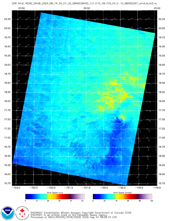
1601z SAR pass does not show a well-organized system (see attachment). Looks like there are two LLCCs and this large N-S gap of light winds and strong asymmetry. I don't know why NHC keeps saying, "conditions generally favorable." That is vague. Dry air and shear are an issue. CMISS 18z analysis showed 18 kt of westerly shear present. Lala was 50 kt/997mb at 03z and still is 50 kt/997mb at 21z. 2156z recon shows these values unchanged. Models still show an upper-level trough developing over the western Hawaiian Island as Lala gets close to the Big Island, so that is not "favorable" in an overall sense. NHC seems to be hedging higher and using persistence IMHO. One possible factor is that topographic convergence may tighten the wind field along the srn tip of the Big Island as gets close for 64 kt winds, but that's a local mesoscale factor not directly related to actual intensification of the TC synoptically. Topographic influences for winds are to be discarded for assigning actual TC intensity AFAIK. It is similar to discarding mesoscale higher winds from intense pulsing convection when shear is present for the TC (Bertha had this big time) or a transient mesovort in the eye. Still a significant impact on Hawaii, not downplaying that, just talking above about the finer details of meteorological analysis, which I hope some find informative.
-
Nice. Got about a half inch here.
-
88 again!
- Today
-
Augdewst 2026: Summer's Last Stand
Damage In Tolland replied to Prismshine Productions's topic in New England
Just have to laugh this off at this point . This shit happens to happen sometimes until it stops happening -
89 yesterday 88 today
-

2026-2027 Record-breaking El Nino
donsutherland1 replied to Stormchaserchuck1's topic in Weather Forecasting and Discussion
I agree. 1972-73, 1982-83, and 2015-16 had 1 or more days with measurable snowfall in Athens. -

2026-2027 Record-breaking El Nino
EasternLI replied to Stormchaserchuck1's topic in Weather Forecasting and Discussion
These are big claims, don't see why not though TBH. -

Augdewst 2026: Summer's Last Stand
dendrite replied to Prismshine Productions's topic in New England
Hopefully virga so you can miss from above too -
Temperatures will top out in the lower to perhaps middle 80s in a few warm spots to start the weekend. Clouds will increase on Sunday holding the temperature to the upper 70s or lower 80s. Showers and thundershowers are likely Sunday night into Monday. A few locations could see heavy downpours. Following the frontal passage, Monday through Wednesday should feature temperatures in the lower 80s, along wth partly to mostly sunny skies. The ENSO Region 1+2 anomaly was +4.1°C and the Region 3.4 anomaly was +2.6°C for the week centered around August 6. For the past six weeks, the ENSO Region 1+2 anomaly has averaged +3.72°C and the ENSO Region 3.4 anomaly has averaged +2.15°C. The ongoing strong El Niño, which has reached super El Niño threshold, will continue to strengthen through the summer. The SOI was -22.03 today. The preliminary Arctic Oscillation (AO) was -0.810 today. Based on sensitivity analysis applied to the latest guidance, there is an implied near 56% probability that New York City will have a warmer than normal August (1991-2020 normal). August will likely finish with a mean temperature near 76.5° (0.4° above normal). Supplemental Information: The projected mean would be 1.3° above the 1981-2010 normal monthly value.
-
Just wait until they leave the house to get married.
-
I’m in the middle of tobacco harvest and the drizzle was enough of a concern for “trailers” that were loaded and outside getting wet that we had to bring them all inside and work around them. Rain sucks when you’re doing massive harvest of anything.
-

Augdewst 2026: Summer's Last Stand
jlauderdal replied to Prismshine Productions's topic in New England
Inbound activity -
Charlottesville to north of town just absolutely got socked over - one of the more powerful storms that I've seen in some time even for over here... And not even a sprinkle in my yard again - just saw more water in a hour than my yard has seen in 2 months - simply wild..