All Activity
- Past hour
-
 Yes. And because Microsoft no longer supports Windows 95, each frame needs to be scanned independently for viruses. And then it has to be double authenticated.
 -

MO/KS/AR/OK 2025-2026 Winter Discussion
JoMo replied to stormdragonwx's topic in Central/Western States
I think 2nd system might save it. 18z NAM is ejecting it out farther west. 18z HRRR was pretty robust as well. -

Possible Record Breaking Cold + Snow Sunday 1/25 - Tuesday 1/27
RedSky replied to TriPol's topic in New York City Metro
A dozen monkeys using abacus -

Possible Record Breaking Cold + Snow Sunday 1/25 - Tuesday 1/27
SACRUS replied to TriPol's topic in New York City Metro
-

Jan 24-26 Weekend Snow and Sleetfest Model Thread Part Tres
jgentworth replied to H2O's topic in Mid Atlantic
Yeah, pretty wild how it can go from being colder at all layers for the entire run but then at 42, the snow line is actually North of the 12z run. Overall though, I liked the steps south in the earlier hours. -

“Cory’s in LA! Let’s MECS!” Jan. 24-26 Disco
DavisStraight replied to TheSnowman's topic in New England
I think it's 1pm Sun to 1pm Mon -

January 24-26: Miracle or Mirage JV/Banter Thread!
bncho replied to SnowenOutThere's topic in Mid Atlantic
??? get some sleep -

Jan 24-26 Weekend Snow and Sleetfest Model Thread Part Tres
stormtracker replied to H2O's topic in Mid Atlantic
wetter than 12z so far -

Possible Record Breaking Cold + Snow Sunday 1/25 - Tuesday 1/27
mikeysed replied to TriPol's topic in New York City Metro
Nam Kuchera is gonna blow minds -

“Cory’s in LA! Let’s MECS!” Jan. 24-26 Disco
TauntonBlizzard2013 replied to TheSnowman's topic in New England
First call:
-
Wait I thought next weekend was @Ralph Wiggum's?
-

Jan 24-26 Weekend Snow and Sleetfest Model Thread Part Tres
MN Transplant replied to H2O's topic in Mid Atlantic
Parent NAM still changes DC over at 12z, but at least there is a bit more precip by then. But really, we should be looking at the 3k from now to the event. -

Pittsburgh/Western PA WINTER ‘25/‘26
ChalkHillSnowNut replied to Burghblizz's topic in Upstate New York/Pennsylvania
Hard to fathom how much cold air is gonna be around yet it’s gonna intrude -

January 25-26 Winter Storm Potential
Ralph Wiggum replied to Ralph Wiggum's topic in Philadelphia Region
Some mixed signals across guidance that suggest maybe spots can hit that criteria with the Feb 1-3 storm threat. -

Pittsburgh/Western PA WINTER ‘25/‘26
southpark replied to Burghblizz's topic in Upstate New York/Pennsylvania

-
“Cory’s in LA! Let’s MECS!” Jan. 24-26 Disco
DavisStraight replied to TheSnowman's topic in New England
Or 5 TO game against Pittsburgh, that's the one I feel was a blown opportunity. -
Jan 24-26 Weekend Snow and Sleetfest Model Thread Part Tres
stormtracker replied to H2O's topic in Mid Atlantic
Sleet incoming at 42. -
Jan 24-26 Weekend Snow and Sleetfest Model Thread Part Tres
bncho replied to H2O's topic in Mid Atlantic
btw the 3k NAM is ALSO noticeably colder in the upper levels than its 12z run -

Jan 24-26 Weekend Snow and Sleetfest Model Thread Part Tres
psuhoffman replied to H2O's topic in Mid Atlantic
High was a little further south with better damming signal into the mid atlantic this run. Minor but we only need minor improvements here -

Jan 24-26 Weekend Snow and Sleetfest Model Thread Part Tres
clskinsfan replied to H2O's topic in Mid Atlantic
Through 12z for those who dont have access: -

Jan 24-26 Weekend Snow and Sleetfest Model Thread Part Tres
Yeoman replied to H2O's topic in Mid Atlantic
That’s the classic CAD/overrunning trap: the cold air is stubborn near the ground, but 850–700 mb winds can crank WAA over it. So you don’t dislodge the high, you just ride precipitation over it and introduce a warm nose. The surface map looks invincible, and meanwhile sleet is doing victory laps. -

1/24-1/25 Major Winter Storm - S. IL, IN, and OH
OHweather replied to A-L-E-K's topic in Lakes/Ohio Valley
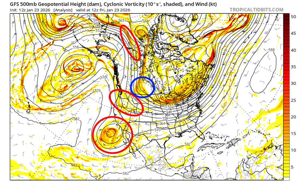
Just a few random thoughts...there've definitely been small but additive bumps SE over the last several runs of the non-GFS guidance. It's largely been caused by the PV over the Upper Midwest/Plains ahead of the storm refusing to lift out at all, along with subtle trends for perhaps a slower ejection of the storm into the Plains (lets the PV press in more ahead of it) and some lingering run-to-run disagreement over how well the storm phases over the southern Plains. Overall, I don't expect more than relatively small adjustments from here on in, but a quick look at how guidance has been trending and what still could change in my eyes... This is the European ensemble mean 500mb heights for the last several runs valid at 12z Sunday. There still are subtle run-to-run adjustments both with the exact placement of the PV and with how well-phased the trough ejecting into the Plains is...to me, the there haven't been substantial trends either way with the PV while the trough has trended perhaps a bit less phased overall. Heights are still rising plenty ahead of the storm and there may be room for a subtle trend back northwest if we see a better phase, but unless we see trends towards the PV lifting out quicker I don't think it makes a huge difference for those who are on the outside looking in for heavy snow. This is just the 500mb height and vorticity trends from the operational Euro...there are not clear trends towards a more or less phased solution overall, though there may be a slight trend for the trough to eject into the Plains slower, which in theory could give the PV a little more of a chance to press in ahead of it. The red circles are the main pieces of energy phasing together with this storm...the Baja low and shortwave diving into Canada have not been fully sampled yet, but will becoming increasingly sampled in the next sets of 0z/12z runs. There may be some opportunity for trends regarding how well the storm phases over those next cycles, though my guess is there won't be a significant trend either way. The shortwave circled in blue isn't really phasing into this, but will help dictate how much the PV presses into the upper Midwest/Plains Lakes north of the storm. My guess is we won't see a notable trend with the PV from here on out, though I've been surprised before. Overall, I think it's the PV over the Plains that is skunking those who needed more of a NW trend than we got and it doesn't seem like that's changing as the storm becomes more imminent. There is still room for subtle trends based on a quicker/slower phase, though any northwest trends won't be huge. It wouldn't shock me if there's enough bump SE before we're done, though I personally don't want that if we can avoid it....thumb.gif.6307205752ec3d05a11a3662f5583c21.gif)
.thumb.gif.54ca0783746cb9a4b9ac9b560a3da26e.gif)
-
BTW, Good luck with your surgery, hope it goes well!
-
Jan 24-26 Weekend Snow and Sleetfest Model Thread Part Tres
stormtracker replied to H2O's topic in Mid Atlantic
Yeah, it came in right after I sent...I'm about to get 45 now -

1/23/26-1/25/26 Winter Storm Thread
Holston_River_Rambler replied to AMZ8990's topic in Tennessee Valley
Here is what I was looking at when I made the south call:


.gif.e44f1c254ef807276a9242e4f2f799f0.gif)
.gif.4e00a1d802c3cce6aff4d98f7ffd86f7.gif)

