All Activity
- Past hour
-

2026 Atlantic Hurricane Season
TheDreamTraveler replied to Stormchaserchuck1's topic in Tropical Headquarters
Here's some other notable super el nino seasons just for comparison. Shockingly 1997 and 2015 have had more activity and ACE up until this point than 2026 has so far. Though notably both did have a major hurricane with Erika in 1997 and Joaquin in 2015 in September. -
EWR currently in 4th place all time wettest months of August 2026: 10.16 Rank Year August Rainfall 1 2011 18.79" 2 1955 11.84" 3 1971 10.63" 4 1942 8.46" 5 2003 8.21" 6 1990 7.71" 7 2007 7.32" 8 1978 7.30" 9 2021 7.19" 10 1974 7.17" 11 1989 7.03" 12 1959 6.94"
-

Augdewst 2026: Summer's Last Stand
Brian5671 replied to Prismshine Productions's topic in New England
shouldn't be a surprise to anyone-another year without a US hit coming unless there's homebrew at some point -
not looking forward to heat/humidity, but nightly storm chances from an active LLJ are very welcome
-
Goin to be Interesting to say the least. https://fortune.com/2026/05/12/lake-tahoe-data-center-49000-residents-power-source/
-
When is it going to be our turn?
-

Augdewst 2026: Summer's Last Stand
Damage In Tolland replied to Prismshine Productions's topic in New England
Assume all will be negative north and east of HFD -
Guess the good news is its not July,August otherwise a ridge is setiing in the next couple days and probably should be a fixture the next several days
-
2026 Atlantic Hurricane Season
TheDreamTraveler replied to Stormchaserchuck1's topic in Tropical Headquarters
What's even more interesting about how hostile this season has been is that what does develop barely lasts for more than a day. Arthur, Christobal and Dolly all lasted a single day. What does make it through the grinder can barely even last if it does form. -

Augdewst 2026: Summer's Last Stand
Cyclone-68 replied to Prismshine Productions's topic in New England
With not even an average hurricane season to distract us…You could theoretically walk across the ITCZ right now without even encountering a cloud -

Augdewst 2026: Summer's Last Stand
weatherwiz replied to Prismshine Productions's topic in New England
Well the structure of the pattern is a bit different this go around with the core of the ridging a bit farther north and east so this bodes well for NY into New England. There will be lots of details to iron out too. For example, there will be a weak stationary front within the region which will be the boundary between unseasonably warm/humid weather versus cooler and less humid. This will be critical because this will establish the instability gradient. Secondly, the real big question is EML advection and can we maintain an EML into the region. -
 More details can be found at https://www.medguideusa.com/guide/stromectol/ - Stromectol guide to avoid side effects.
 -
Oh i could never be a politician. I’m too honest for that
-

E PA/NJ/DE Summer 2026 Obs/Discussion
RedSky replied to PhiEaglesfan712's topic in Philadelphia Region
1.30" total -
Augdewst 2026: Summer's Last Stand
Damage In Tolland replied to Prismshine Productions's topic in New England
No reason to break the summer pattern. Those two zones locked in , in May and has been relentless with each front -
Oh, phew...
-
Some of the maples here in town showing a little color, but that is mainly due to drought stress. Colors may be less robust unless we get good rains coming up.
-
warm and rainy
-
Well, at least 2023 snowed in vermont. 2015 was an utter shut out. Not an accumulating flake even at elevation, and repeated washouts. I'm already mentally prepared for the skiing in northern VT to be garbage this december but there are certainly levels of garbage.
-
Augdewst 2026: Summer's Last Stand
weatherwiz replied to Prismshine Productions's topic in New England
Looks like High Pressure building in late next week behind the passage of the front late Wednesday which would bode well for a dry weekend -

Summer 2026 Med/Long Range Discussion
BeastFromTheEast replied to Brian D's topic in Lakes/Ohio Valley
Labor Day pm a lock to be hot and humid. Summer going out with a bang!! Looking forward to the juiced up storm opportunities too! -
They were both brutal...like...how painful? Slam the refrigerator door shut on my balls, or kick me as hard as you can?
- Today
-
Should I feel honored?
-
Hi guys, hate to interrupt, but my daughter’s getting married 9/5 in Sterling Ct. Ryan’s 10 day looks good, but any thoughts would be greatly appreciated. Cheers
-
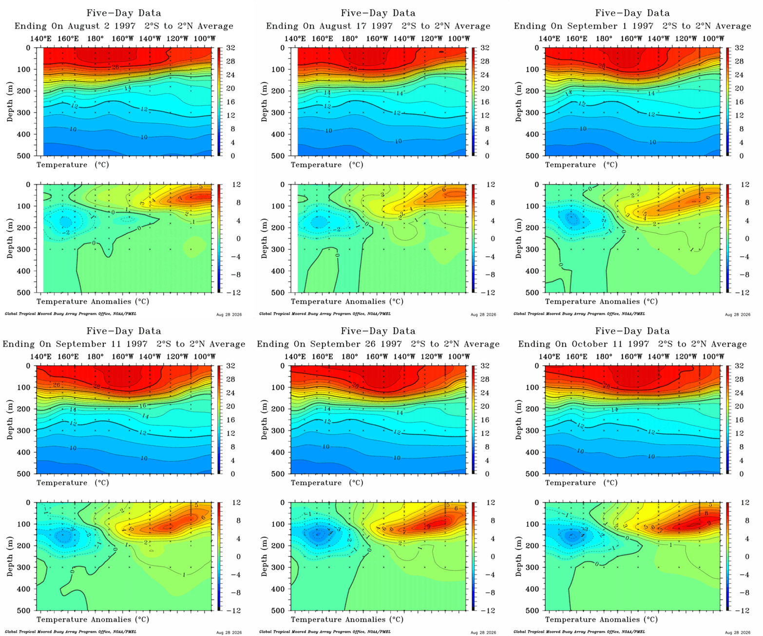
 I will probably have to delete some attachments soon but doing a quick comparison to 1997 and 2026, slightly off time frames but similar process took place and we maybe should see similar results happen? Ill make one for 10-16 to end of 1997 at some point. Shame we have so much cutoff right now. Open up new window and check them side by side to get a better comparison.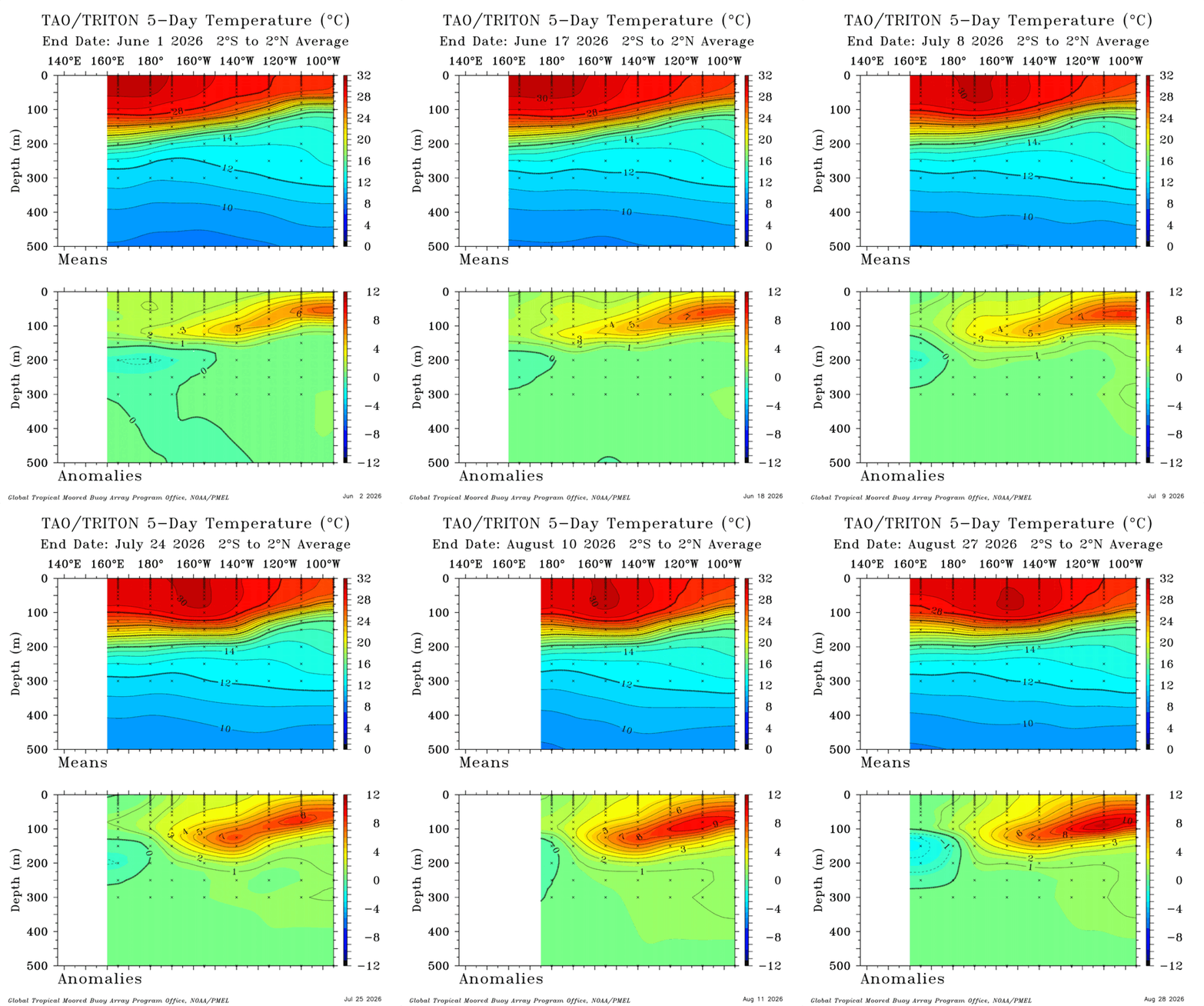

.thumb.jpg.ad3a2e31d30aff035044689b311a0540.jpg)