All Activity
- Past hour
-
Not sure about this, but I just got an alert for a tornado watch in the metros. It was from Alexa and she’s a whacko so I’m not sure.
-
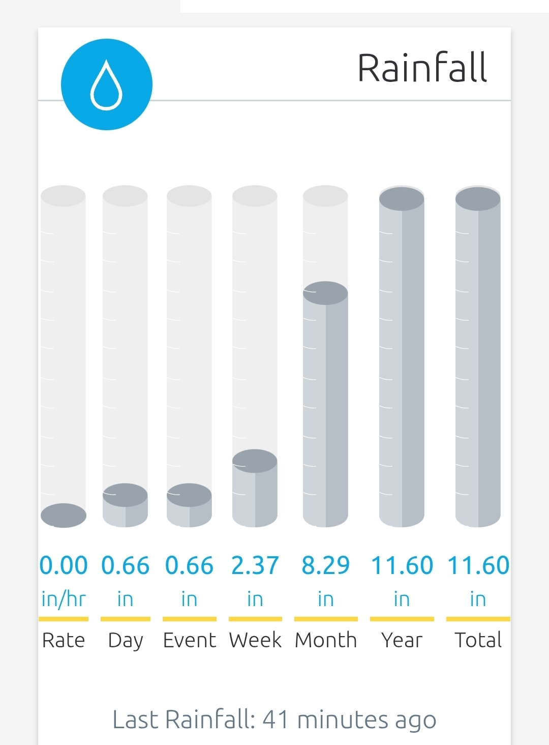
Seems like a real chance at a 9" month if this next batch is solid
-

E PA/NJ/DE Spring 2025 Obs/Discussion
Hurricane Agnes replied to PhiEaglesfan712's topic in Philadelphia Region
Tornado Watch for the area - -
Showers with some downpours here the past two hours. Now the good stuff is headed this way.
-
Euro/GGEM bang 6/6.
-
12z still shows that
-
Man that hook looks to be heading my way...yikes
-
Very dark to my south west…constant rumbling…
-
Looking at the radar, feels like a winter storm, watching the heavy returns creep NE. Your not wrong. Sunday looks nice, then we should get a taste of summer.
-

2025 Spring/Summer Mountain Thread
Met1985 replied to Maggie Valley Steve's topic in Southeastern States
Heavy rain and storms moving through again this evening. Temps have dropped from mid 60s to mid 50s now. -
-
- 842 replies
-
- 1
-

-
- severe
- thunderstorms
- (and 2 more)
-
That line should be in DC metro around 8pm... Tornado warned portion is on path for the metro
- 842 replies
-
- 1
-

-
- severe
- thunderstorms
- (and 2 more)
-
Maybe bonus Canadian wildfire smoke?
-
Just what hippie wants more rain.
-
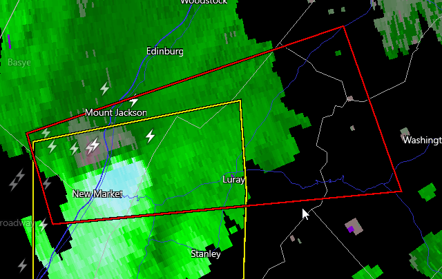
BULLETIN - EAS ACTIVATION REQUESTED Tornado Warning National Weather Service Baltimore MD/Washington DC 550 PM EDT Fri May 30 2025 The National Weather Service in Sterling Virginia has issued a * Tornado Warning for... Southern Shenandoah County in northwestern Virginia... Central Rockingham County in western Virginia... Southwestern Warren County in northwestern Virginia... Northern Page County in northwestern Virginia... West central Rappahannock County in northwestern Virginia... * Until 630 PM EDT. * At 549 PM EDT, a severe thunderstorm capable of producing a tornado was located near Mount Jackson, or 16 miles southwest of Woodstock, moving east at 40 mph. HAZARD...Tornado. SOURCE...Radar indicated rotation. IMPACT...For those in the direct path of a tornado touchdown, flying debris will be dangerous to those caught without shelter. Damage to roofs, siding, and windows may occur. Mobile homes may be damaged or destroyed. Tree damage is likely. * This dangerous storm will be near... Luray and Mount Jackson around 555 PM EDT. Sperryville around 615 PM EDT. Other locations impacted by this tornadic thunderstorm include Kimball, Kings Crossing, Compton, Shenandoah Caverns, Leaksville, Hamburg, Fourway, Quicksburg, Fairview, and Bentonville. PRECAUTIONARY/PREPAREDNESS ACTIONS... TAKE COVER NOW! Move to a basement or an interior room on the lowest floor of a sturdy building. Avoid windows. If you are outdoors, in a mobile home, or in a vehicle, move to the closest substantial shelter and protect yourself from flying debris. && LAT...LON 3861 7874 3872 7878 3885 7829 3865 7820 TIME...MOT...LOC 2149Z 256DEG 36KT 3867 7867 TORNADO...RADAR INDICATED MAX HAIL SIZE...<.75 IN
-

E PA/NJ/DE Spring 2025 Obs/Discussion
mattinpa replied to PhiEaglesfan712's topic in Philadelphia Region
Tornado watch up until midnight. First of the year -
Torrential rain I just received from this activity in Herndon.
-
Classic jinx - that’s some broad but strong rotation for these parts
- 842 replies
-
- 1
-
-
- severe
- thunderstorms
- (and 2 more)
-
Tornado Warning near Mount Jackson
-
WPC flash flooding meso out for metro areas and points north
- 842 replies
-
- 1
-
-
- severe
- thunderstorms
- (and 2 more)
-
Hope people get fun storms but not overly impressed with what I’m seeing thus far
-
Bump
-
There was horizontal rotation I’ll send a picture later
- 842 replies
-
- 2
-
-
- severe
- thunderstorms
- (and 2 more)
-
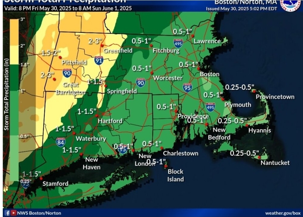
Jackpot has always been Western areas of SNE. Find me one post where Eastern SNE was going to get a lot of rain? 1-3 inches days ago and it still is. .