All Activity
- Past hour
-
 Edit: WU just went to 96.
 -
 Friday may even deserve its own thread. May fire one up a little later.
 -
NWS, Weather Underground, and NBC CT HFD are 3 that I'm aware of that are 97 here today. We'll see how it plays out.
-
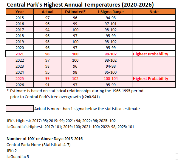
Given NCEI's and the Central Park Conservatory's choice to permit tree overgrowth to persist at Central Park's ASOS, I've run the statistical model to see what Central Park's highest annual temperatures might have been had the statistical relationships to the 30-year period preceding the tree growth persisted (proxy for pre-tree readings). The estimated 102° reading in June 2025 would have set a new monthly mark. During 2015-2026, Central Park would likely have seen four to as many seven 100° readings. 2021 and 2025 had the highest likelihood that Central Park would have recorded one or more 100° or above readings. In an increasing number of cases, Central Park's reported highest temperature falls more than 1 standard deviation below the statistical estimate.
-
 NWS is hitting 97 in the CRV
 -
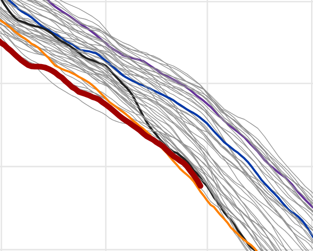
New record relative to what? Do you mean monthly or whole year? -I'm assuming month. This rusty dark curve doesn't look like 5th lowest, per date though. As far as yearly, given that steepness of this delta, that doesn't really infer it won't end up lower then every other member ( May-June-July), but obviously too early to get a fix on that. I don't know about Climate Reanalyzer accuracy and statistics therein ? but this is off their product fwiw. https://climatereanalyzer.org/clim/seaice_daily/?nhsh=nh
-
86/71 right now. The roast begins
-
Weak llvl flow but Friday has my attention on the NAM...
-
Looks like LWX upgrading western MD and the WV panhandle. Makes sense. We definitely appear to be outpacing guidance for at least today.
-
 What source has 97 ?
 -
Off to a slow start at 82. Might be more like 94-95 vs 97. We'll see.
-
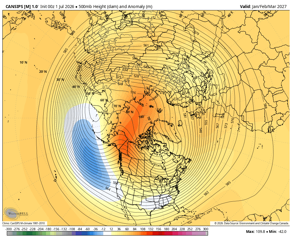
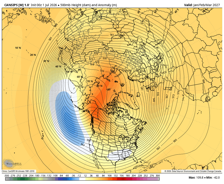
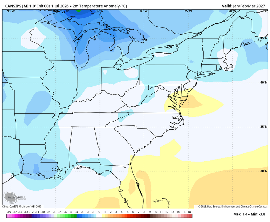
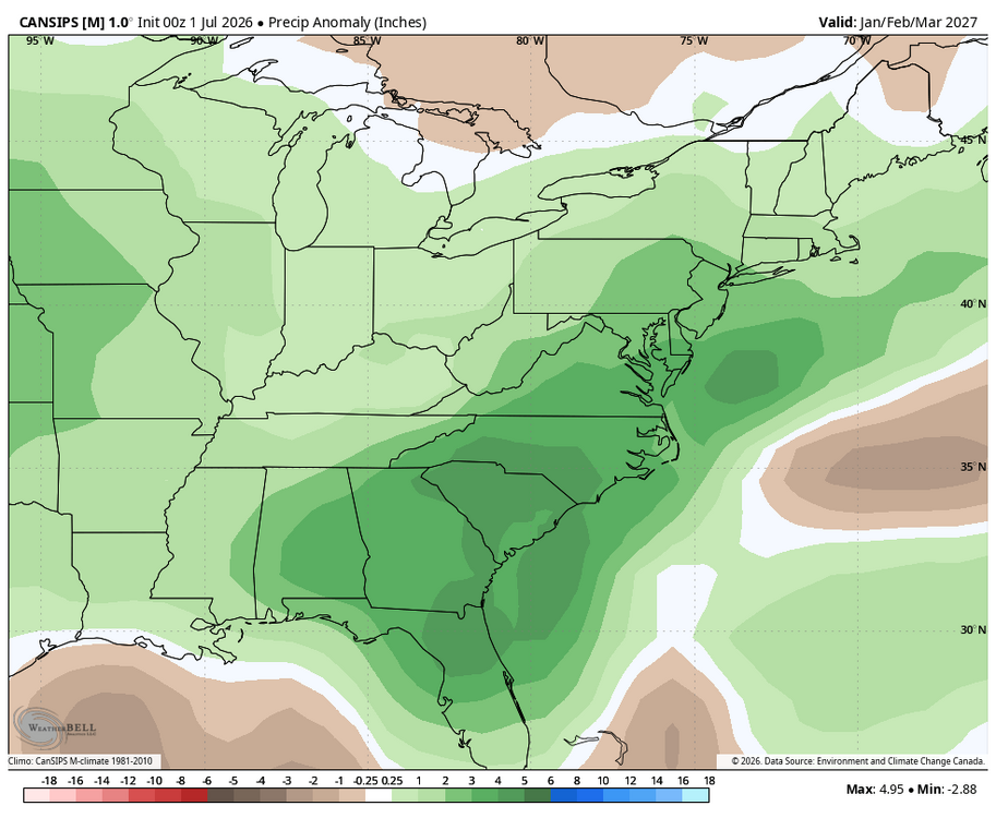
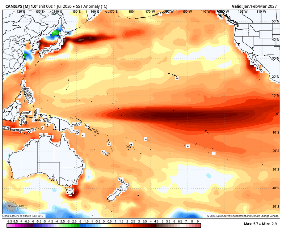
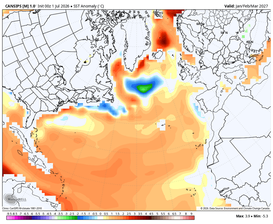
WB 7/1 Canad. Jan-Mar. looks wet, hopefully will get enough cold...
-
Damn, hope he’s okay. Here in Chicago it’s already stifling this morning.
-
Little bit of tree rustling and WNW breeze here. AWT, less cloud has resulted. Some up over SE NH but that's got a short lease on life I presume. Open sky heating here now. 85/71, up 9 in the last 1.5 hours. We'll see how '10 after 10' works out -
-
Hitting 90 before 10 AM today. If we mix out dews we probably break 100. Got close yesterday.
-
Down here in the Roan Highlands of NC at 3800 feet, the highest temp I’ve recorded in my two years of living here is 82. Unfortunately looks like we will break that this week. Beech Mountain, NC highest temp ever recorded is 83.
-
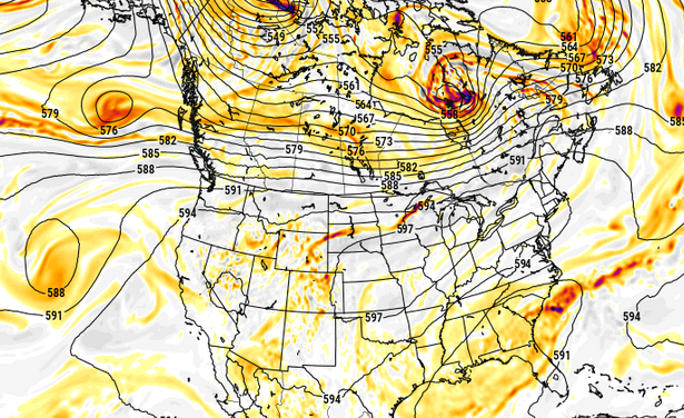
Nasty heat at the end of the Euro run (inferred) ... This was a purely SW lava puke that gets trapped over Chi-town ...with (probably in this kind of structure -) briefer inject through our region. But what's up with the over-zealous polar jet over top in Canada, huh. That's what keeps it brief for us - again ... if this depiction should prevail. which it won't but just sayn
-
The Washington County mesonet sites already pushing HI of 100° before 11am is impressive. Those are all calibrated sensors too!
-
3.55" on the month.
-

E PA/NJ/DE Summer 2026 Obs/Discussion
JTA66 replied to PhiEaglesfan712's topic in Philadelphia Region
Took one last Jebwalk this morning for the week. Already 82F/ DP72F. Of course, that's going to seem refreshing come the next several days. -
 I've been curious about this for some time and had trouble discerning where a break-even is after initial purchase. I know there were subsidies involved in a lot of installations that helped but I've also heard people mention panels degrade over time and/or there are maintenance costs to factor in (panel replacement, batteries, etc). I imagine you've hit a break-even at some point during this stretch. Do you happen to know when it was and how far ahead you are?
 -

2026-2027 Super El Nino
michsnowfreak replied to Stormchaserchuck1's topic in Weather Forecasting and Discussion
I know my own climate very well, but I have also learned a decent amount about the east/midatlantic after being on weather boards for 2+ decades. Warm/cold/etc are always very relative, subjective terms. It absolutely will snow here in November & December. My hunch is for above avg snow in Nov & below avg in Dec, but thats just my hunch (based on strong Nino history & an odd frequency of this occurring in even non-Nino years recently). Id lean on an avg to cold November and a mild December, but even if its warm both months, the transition to winter in the Great Lakes from Oct to Nov is a sharp one, and is very apparent even in the warmest years. Meanwhile, on the east coast/midatlantic, early season snow is never a strong bet, even in a cold pattern. So in a more hostile strong Nino pattern, bad odds just got worse. So while its not impossible, dont count on much pre-Christmas snow. January-February is when the Great Lakes region is often thrust into deep winter, so you have options ranging from that to a warmer, less favorable outcome which would actually yield a good chance for dynamic, powerful wet snowstorms. This is the time of year when literally everything has to go wrong to not see much winter. Meanwhile in the east, Jan/Feb is when climo hits its sweetspot. Pair this with a time when the overall pattern becomes more wintry for much of the nation following the assumed mild December, and the tendancy/STJ in strong Ninos for strong storms, and this is when you can be on high alert for possible huge storms. -

2026-2027 Super El Nino
40/70 Benchmark replied to Stormchaserchuck1's topic in Weather Forecasting and Discussion
Yea, extreme anomalies throughout ENSO precludes a cold season, but also favors some variability. Just to be clear, while we should get some colder windows that will present an opportunity for significant snows, more likely during the second half, the cold periods will pale in comparison to the warm periods....so no need to bombard me with terd and weenie emojis. -

Central PA Summer 2026 Discussion/Obs Thread
mahantango#1 replied to Voyager's topic in Upstate New York/Pennsylvania
Grass is growing where I'm at. I mowed last Thursday and by Sunday it looked like I didn't even mow. Of course last week I received 1.85 rain which was needed.