All Activity
- Past hour
-
Hopefully this blows up offshore and we get some epic vis images.
-

January 2026 regional war/obs/disco thread
Torch Tiger replied to Baroclinic Zone's topic in New England
the most uninteresting 18" of snow anyone has ever seen, and disappeared like nothing -
The fact that the EPS doesn’t have it is a red flag with the op EURO. I honestly can’t remember the last time we had a true Norlun in the metro area. Anyway, the UKMET finally loaded and it looks like the ICON and CMC. After what it did the last 2 days the op GFS should be tossed, luckily the GEFS was showing that its op runs have been total nonsense. The EPS, NWS National Blend of Models and AI EURO have a very minor event and that would be the way to go IMO. The GEPS comes out soon but it hasn’t budged in days and I don’t expect the new run to either
-
We now seem to have a focus on Thursday/Friday. As I have said recently, I don't like complication. There is a near certainty of changes. Some will be happy with changes and some, not so happy.
-
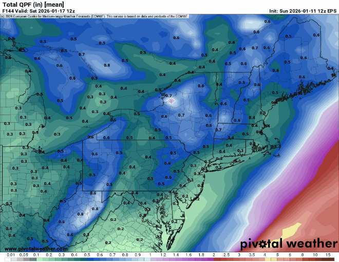
Total Eps snowfall.
(4).thumb.png.c53dc5d647a6ac9b21f6166cad05cf3b.png)
-
Still need more midweek midstate juice!
-
Good looking run of the 12z ensembles today. As noted so there is no confusion...there is a ridge forecast to roll through from roughly the 22-25th. All three major ensembles are now showing the potential for yet more cold to arrive around the 25th or just after. That is good news. On modeling earlier in the week, the EPO kept retrograding into Asia and the wait for more cold could well have lasted through the first week of Feb(that is still on the table BTW). We are also seeing deterministic models flirt with VERY cold air masses. When we see the big highs which Jed mentions, that is usually an indicator of another cold air mass. The end of the Euro was frigid. We won't see that type of Euro every time, but ensembles do support the potential for yet more cold. The big thing to watch for is continue blocking over the top w/ ridging in the eastern Pacific. And we aren't having to wait 14 days for more cold...it is cold right now.
-
Would not surprise me. Cold springs have become the norm here. Sigh Cold rains. Yuck.
-
AniIntense downpour of graupel just passed through Damascus. The ground is coated with “styrofoam” pellets…very cool
-
This just in from skynet to SNE...

-
So a typical snow. Cool.
-
Thankfully it's not the other way around lol
-
12z EPS is actually a slight increase from 6z on Thursday's potential.
-
There is a lot of spread on the EPS for the 15-16th.
-
The end of the gfs was about to send it to. Had a 1060 parent HP in Canada and a 1055 in SE Montana.
-
Thats exactly my point. Scooter be damned
-
Ukmet finally ran and I wish it didn’t. Shows nothing pretty much like cmc. So it’s the cmc and ukemt vs gfs and euro
-

January 2026 Short/Medium Range Thread
Holston_River_Rambler replied to John1122's topic in Tennessee Valley
Speculation post: If patterns run in cycles, it's been almost exactly 60 days since we had an anomalous shortwave dropdown over the southern Apps and drop some early season snowfall. 11/11/25: Jan 15 2026 Overall NA pattern isn't quite the same, but thus the: #speculative Would be interesting if we got another rerun of this in early March. -
Snowing in DC!
-
The EPS supports this.
-
Totally agree. Just need to avoid too much backsliding in the meantime.
-
MJO forecasts aren’t conductive for entrenched warmth.
-
This is one of these systems that's going to be off and on until your inside 4 days or so to know where its going, Lot going on aloft.
-
The OP Euro is trying to show a Norlun trough which seldom works out for our area. The EPS means don’t show it. But it’s always possible a narrowly focused Norlun develops somewhere between ACY and Boston with the UL. It would probably be a nowcasters special for the short term higher res models since they are never well forecast much in advance.
-

January 2026 regional war/obs/disco thread
Damage In Tolland replied to Baroclinic Zone's topic in New England
It was evident a week ago it would basically be one or two mild days with no big warmth


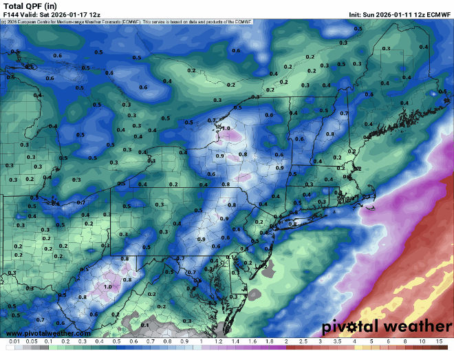
(4).png.a7e7f62e6f026a2e61bf2911766303e3.png)