All Activity
- Past hour
-

Central PA Summer 2026 Discussion/Obs Thread
Voyager replied to Voyager's topic in Upstate New York/Pennsylvania
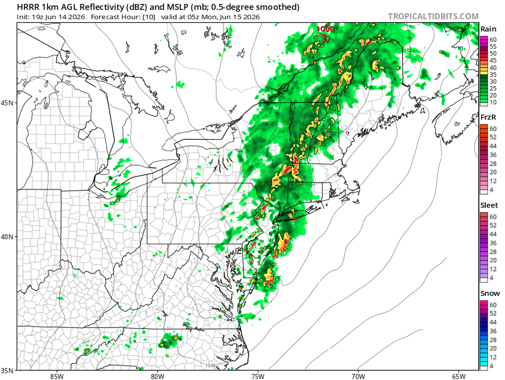
I can't believe the main line is till out in Erie and Ohio. I thought it would have been farther east by now. Was it supposed to be so late? -

Central PA Summer 2026 Discussion/Obs Thread
yoda replied to Voyager's topic in Upstate New York/Pennsylvania
TOG near Sykesville PA Severe Weather Statement National Weather Service Pittsburgh PA 445 PM EDT Sun Jun 14 2026 PAC065-142100- /O.CON.KPBZ.TO.W.0014.000000T0000Z-260614T2100Z/ Jefferson PA- 445 PM EDT Sun Jun 14 2026 ...TORNADO WARNING REMAINS IN EFFECT UNTIL 5 PM EDT FOR SOUTHEASTERN JEFFERSON PA COUNTY... At 445 PM EDT, a confirmed tornado was located near Reynoldsville, or 7 miles north of Punxsutawney, moving east at 30 mph. HAZARD...Damaging tornado. SOURCE...Law enforcement confirmed tornado. IMPACT...Flying debris will be dangerous to those caught without shelter. Mobile homes will be damaged or destroyed. Damage to roofs, windows and vehicles will occur. Tree damage is likely. Locations impacted include... Reynoldsville, Sykesville and Anita. PRECAUTIONARY/PREPAREDNESS ACTIONS... Move to an interior room on the lowest floor of a well-built building away from windows. If you are outdoors, in a mobile home, or in a vehicle, move to the closest substantial shelter and protect yourself from flying debris. && LAT...LON 4106 7902 4113 7880 4099 7880 4099 7898 TIME...MOT...LOC 2038Z 259DEG 25KT 4103 7899 TORNADO...OBSERVED MAX HAIL SIZE...<1.00 IN -
Not a lot going on where that thing tracked.
-

E PA/NJ/DE Summer 2026 Obs/Discussion
The Iceman replied to PhiEaglesfan712's topic in Philadelphia Region
80% pops for tonight… all respect but I just don’t see it. Looking like scattered showers at best. vegetation in lower bucks looks mid August. Really need the next front to bring some rain. Only at .4” this month. -
Hrrrrrrrrrrr 3k NAM nothing looks impressive atm, timing is really bad

-
We got blessed with a third of an inch of rain here in Pine Knolls over the course of a half hour. 78.4/74.8 29.80in
-
I mean TDS height approaching 10 kft and Vrot of 25 kt would put you in the high end EF1/low end EF2 range. So I would think we would eventually hear something.
-
Per LWX, on the 12z KIAD sounding, PWAT was 1.05. On the 18z, it was 1.52
-

2026 Mid-Atlantic Severe Storm General Discussion
Eskimo Joe replied to Kmlwx's topic in Mid Atlantic
Wow- 693 replies
-
- 2
-

-
- severe
- thunderstorms
- (and 7 more)
-
Well per the TBWI radar, the bay breeze has made it west of me here in Odenton and it continues to push west a bit. So if that will be the dividing line/focal point for severe storms vs more garden variety stuff - then a good chunk of the area will be east of that.
-
another day at 95+ for DC.
-
Pittsburgh PA Summer 2026 Thread
yoda replied to TheClimateChanger's topic in Upstate New York/Pennsylvania
Confirmed TOG by spotters BULLETIN - EAS ACTIVATION REQUESTED Tornado Warning National Weather Service Cleveland OH 425 PM EDT Sun Jun 14 2026 The National Weather Service in Cleveland has issued a * Tornado Warning for... Northeastern Crawford County in northwestern Pennsylvania... * Until 515 PM EDT. * At 425 PM EDT, a confirmed tornado was located near Cambridge Springs, or 9 miles north of Meadville, moving east at 50 mph. HAZARD...Damaging tornado. SOURCE...Weather spotters confirmed tornado. IMPACT...Flying debris will be dangerous to those caught without shelter. Mobile homes will be damaged or destroyed. Damage to roofs, windows, and vehicles will occur. Tree damage is likely. * The tornado will be near... Meadville and Cambridge Springs around 430 PM EDT. Guys Mills around 435 PM EDT. Lincolnville, Canadohta Lake, and Riceville around 440 PM EDT. Titusville around 450 PM EDT. Other locations impacted by this tornadic thunderstorm include Venango, Townville, Woodcock, Blooming Valley, Saegertown, and Hydetown. -
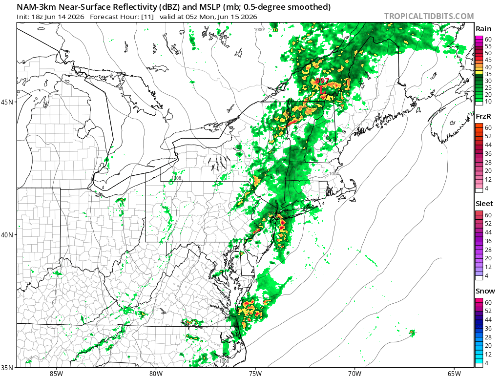
URGENT - IMMEDIATE BROADCAST REQUESTED Severe Thunderstorm Watch Number 335 NWS Storm Prediction Center Norman OK 415 PM EDT Sun Jun 14 2026 The NWS Storm Prediction Center has issued a * Severe Thunderstorm Watch for portions of District Of Columbia Western and Central Maryland Central and Northern Virginia Eastern Panhandle of West Virginia Coastal Waters * Effective this Sunday afternoon and evening from 415 PM until 1100 PM EDT. * Primary threats include... Scattered damaging wind gusts to 70 mph likely Isolated large hail events to 1.5 inches in diameter possible SUMMARY...Thunderstorm coverage is expected to increase this afternoon and evening within the warm, moist, and unstable environment in place across the region. Recent 18Z sounding at IAD sampled 42 kt of 0-6 km shear, which is more than sufficient for updraft organization. General expectation is for multiple rounds of occasionally severe storms, with damaging gusts as the primary severe hazard. Isolated instances of large hail could occur as well. The severe thunderstorm watch area is approximately along and 70 statute miles east and west of a line from 25 miles northeast of Martinsburg WV to 40 miles southeast of Lynchburg VA. For a complete depiction of the watch see the associated watch outline update (WOUS64 KWNS WOU5).
- 693 replies
-
- 3
-
-
- severe
- thunderstorms
- (and 7 more)
-
- 693 replies
-
- 3
-
-
- severe
- thunderstorms
- (and 7 more)
-
Entire area west of the Bay under a severe thunderstorm watch until 11.
-

E PA/NJ/DE Summer 2026 Obs/Discussion
Birds~69 replied to PhiEaglesfan712's topic in Philadelphia Region
89F/DP 67F at 4:20pm. We'll probably eek 90F.... -

-

2026 Mid-Atlantic Severe Storm General Discussion
George BM replied to Kmlwx's topic in Mid Atlantic
Mr. Blue Box coming out until 11pm EDT.- 693 replies
-
- 1
-
-
- severe
- thunderstorms
- (and 7 more)
-
https://twitter.com/tim_grooms/status/2066243886733742497?s=46&t=JYOHM881b6groqc0-RqtxA
- 693 replies
-
- 1
-
-
- severe
- thunderstorms
- (and 7 more)
-
Falls apart next frame
-

2026 Mid-Atlantic Severe Storm General Discussion
SnowenOutThere replied to Kmlwx's topic in Mid Atlantic
Thanks for responding/correcting me. I suppose my main take was based on assuming the storm initiation method would be the same. To my knowledge Friday and Thursday had storms due to the Lee trough and intense heating generating cape and basically hitting convective temp around 3pm. I didn’t realize today was more synoptic based for storm development. I suppose I haven’t had practice with these yet. Though, I never thought that if storms popped they wouldn’t be nasty with the increased, especially considering WxUSF mentioning we are now 2000+ CAPE. -
Anything that will have the potential to be severe needs to pop off between now and sunset. "Squall" line comes in too late. Sea breeze storm euthanasia is well inland here.
-
Brown water effect. It’s been wet in the Miss River Valley recently.
-
2026 Mid-Atlantic Severe Storm General Discussion
SnowenOutThere replied to Kmlwx's topic in Mid Atlantic
You got a link to that? Preferably the height temp dep point sheet. I still have some full page skew-T sheets I took from my lab at UVA and would love to do a hand written analysis -
I’ll always root for Big East players/teams, glad to see Brunson/Bridges/Hart win.


.thumb.jpg.a628c2147efdff1c820341d5143d9237.jpg)


.thumb.jpeg.f5c6ba9d911ec96b3b124f8606aee58e.jpeg)

