All Activity
- Past hour
-
WB 18Z EPS looks good too.

-

Possible Record Breaking Cold + Snow Sunday 1/25 - Tuesday 1/27
Prue11 replied to TriPol's topic in New York City Metro
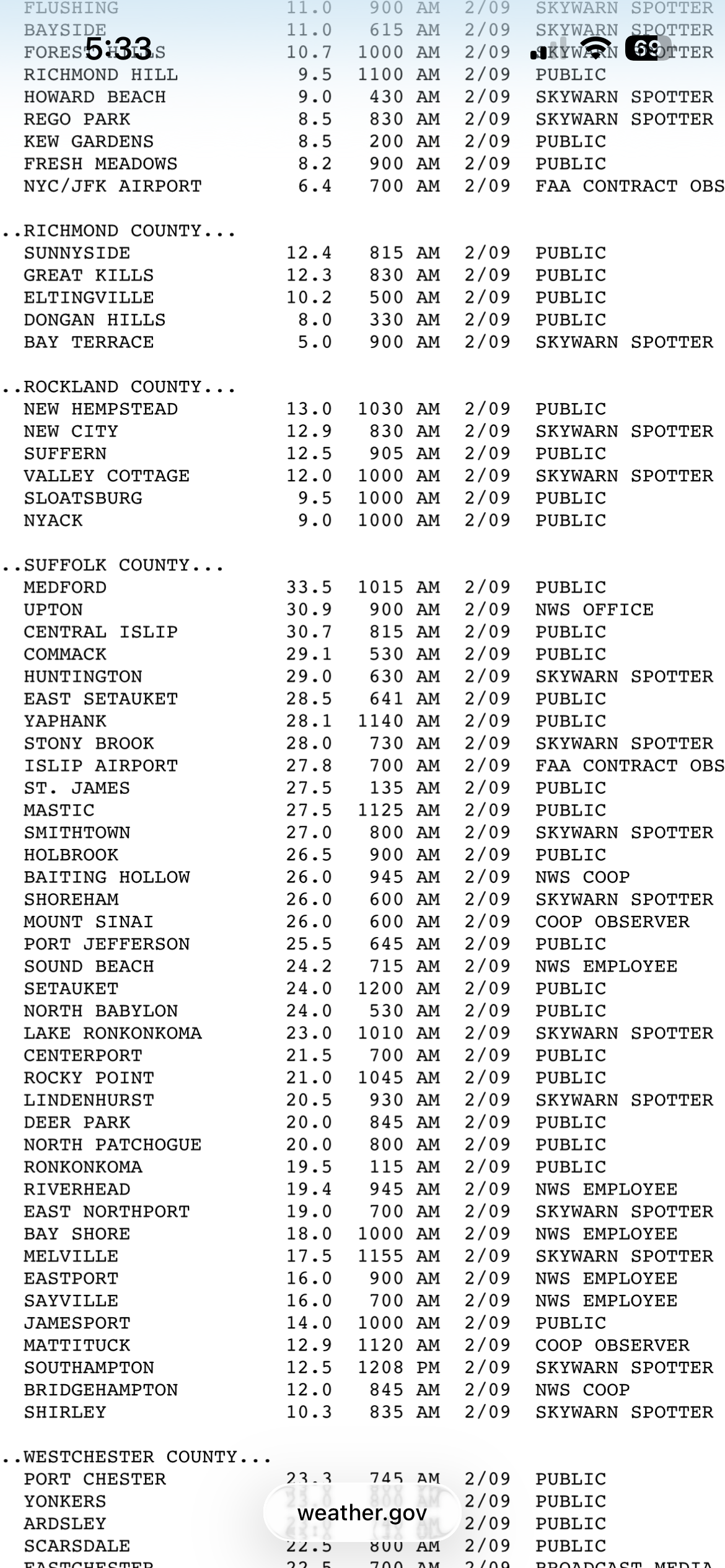
@wthrmn654 @Blizzardo https://www.weather.gov/okx/storm02092013 -
He had 1” I saw
-

Possible Record Breaking Cold + Snow Sunday 1/25 - Tuesday 1/27
SnoSki14 replied to TriPol's topic in New York City Metro
Don't assume it can't trend better either. Either way we don't control the weather...no sense in getting angry about it if it doesn't work out. -
Think this forecast discussion from KFFC is really well done. Talks a lot about their feelings on the northern trends of last night and context around that. https://forecast.weather.gov/product.php?site=NWS&issuedby=FFC&product=AFD&glossary=1 Used to live in ATL area so tracking for family there, but no dog in the fight now certainly makes it easier to stay level headed. Really hope some of you guys score.
-
I'm just looking at the same stuff y'all are, hoping the GFS is closer to accurate. That 18z run put about 4 inches of snow down at TYS before switching to half inch of freezing rain and then back to snow for 3 more inches. That's with the cobb snow algorithm. Temps in the upper 20s through all of it until crashing to zero Sunday night. That frozen sandwich would be around for while. Better than pure ice, and better than ending on rain!
-
Ryan blew this
-
Possible Record Breaking Cold + Snow Sunday 1/25 - Tuesday 1/27
Prue11 replied to TriPol's topic in New York City Metro
My buddy had to abandon his car on LIE like many others. It was impossible travel -

January 24-26: Miracle or Mirage JV/Banter Thread!
Wxtrix replied to SnowenOutThere's topic in Mid Atlantic
i got 34". so it's definitely not accurate. -
Looks stronger than modeled right to srn CT coast. Unless it weakens which is possible.
-
Possible Record Breaking Cold + Snow Sunday 1/25 - Tuesday 1/27
Prue11 replied to TriPol's topic in New York City Metro
Nope it was 2/8 and 2/9 2013 just googled it -

Possible Record Breaking Cold + Snow Sunday 1/25 - Tuesday 1/27
Blizzardo replied to TriPol's topic in New York City Metro
Nemo was 2015 if I recall. NJ was forecast 18-24 and only the NAM that no one believed had it pegged going wide right hitting Eastern LI with the big snow. -

Richmond Metro/Hampton Roads Area Discussion
Conway7305 replied to RIC Airport's topic in Mid Atlantic
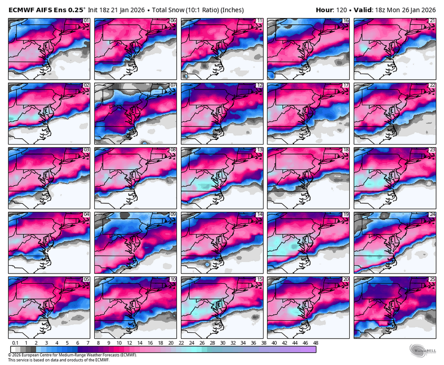
hmmmmm. this is interesting with 18z AIFS euro ensembles. Paints a completely different picture. I have no clue as to the reliability on the AIFS or their ensembles, but they both look great.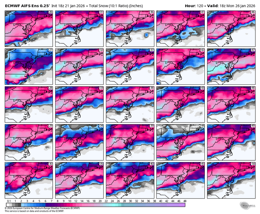
-

“Cory’s in LA! Let’s MECS!” Jan. 24-26 Disco
The 4 Seasons replied to TheSnowman's topic in New England
That ain't Narcan, that's a straight main line of pure medical grade fent. -
So we have been aiming for less phasing! That is what was confusing me about this run as well...so we got less and yet the end result was...worse? If it turns out that way that means it would've literally invented a way to fail, lol But let's hope not
-
Yeah I looked at the run at h5 only first and was very surprised that it turned out the way it did by the end of it at the surface. I think another trend like that out west and things would change noticeably. Not a run to run change that is good for phasing imo so if it does become a trend this could go back south
-
Yes. It may waiver back and forth a bit from run to run, but I would be surprised if the outcome ends up much different. Maybe I'm wrong putting more "faith" in the Euro than other guidance, but AI I don't fully trust yet, CMC is almost always crap, and the GFS...well, lol. See what the Mesos look like as we get into their range.
-

“Cory’s in LA! Let’s MECS!” Jan. 24-26 Disco
Baroclinic Zone replied to TheSnowman's topic in New England
Kinda tough to not ride the consistency of the Euro suite. Op/EPS/AI-Op/AI-EPS. -
Possible Record Breaking Cold + Snow Sunday 1/25 - Tuesday 1/27
Prue11 replied to TriPol's topic in New York City Metro
Nemo
-

Central PA Winter 25/26 Discussion and Obs
MAG5035 replied to MAG5035's topic in Upstate New York/Pennsylvania
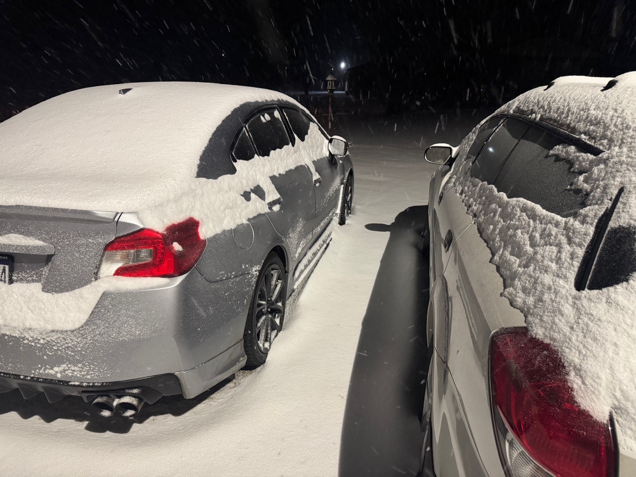
2.5” so far this evening here, what a nice surprise. Was down at our camp in NW Huntingdon Co earlier and about the same there as well. Roads are a mess.
-

January 24-26: Miracle or Mirage Thread 2
NorthArlington101 replied to mappy's topic in Mid Atlantic
AIFS Ens really struggle to show mixing/sleet. -
High of 30F. Snowpack holding strong. Although tomorrow’s 40F will likely destroy it.
-
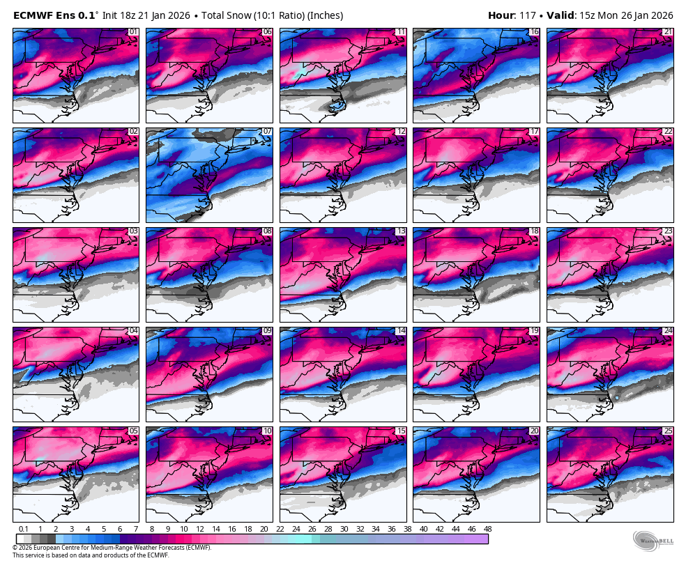
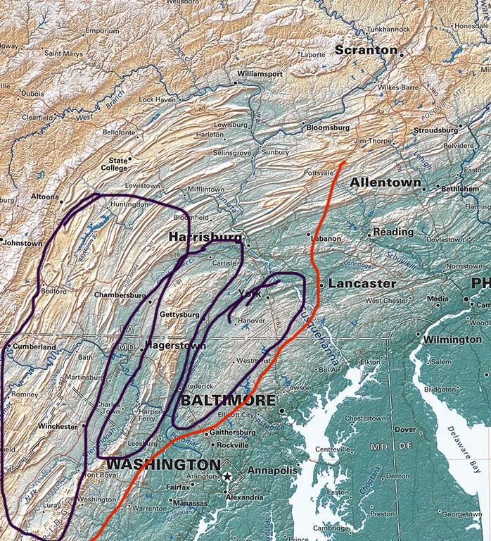
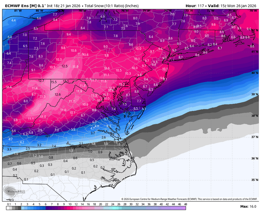
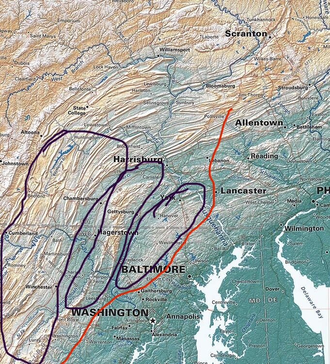
Fall line climo will likely come into play with this one. One things for sure, it’s a QPF bomb. I’m really serious when I say areas that stay all snow will likely see 15-20” and could even get close to 2’. Best spots right now I would put across the M/D with the eastern most area near @mappy and as far north as Harrisburg. Southern edge for that potential is probably the Parrs Ridge zone down Rt27 towards Damascus/Mt Airy and points northwest. Map below is prelim thoughts and NOT my official forecast. Just an outline of thoughts right now. If you are northwest of the red line, I believe you’ll see 10+”, if you are inside the purple, I believe 12-18” is a good forecast right now. Elevations above 800’ have best chance to see 15-20”. Local maxima of 23” is the initial thought. Note, this is manly for this subforum and some of PA. I didn’t try too hard for areas outside the sub, but I will for full forecast.
-
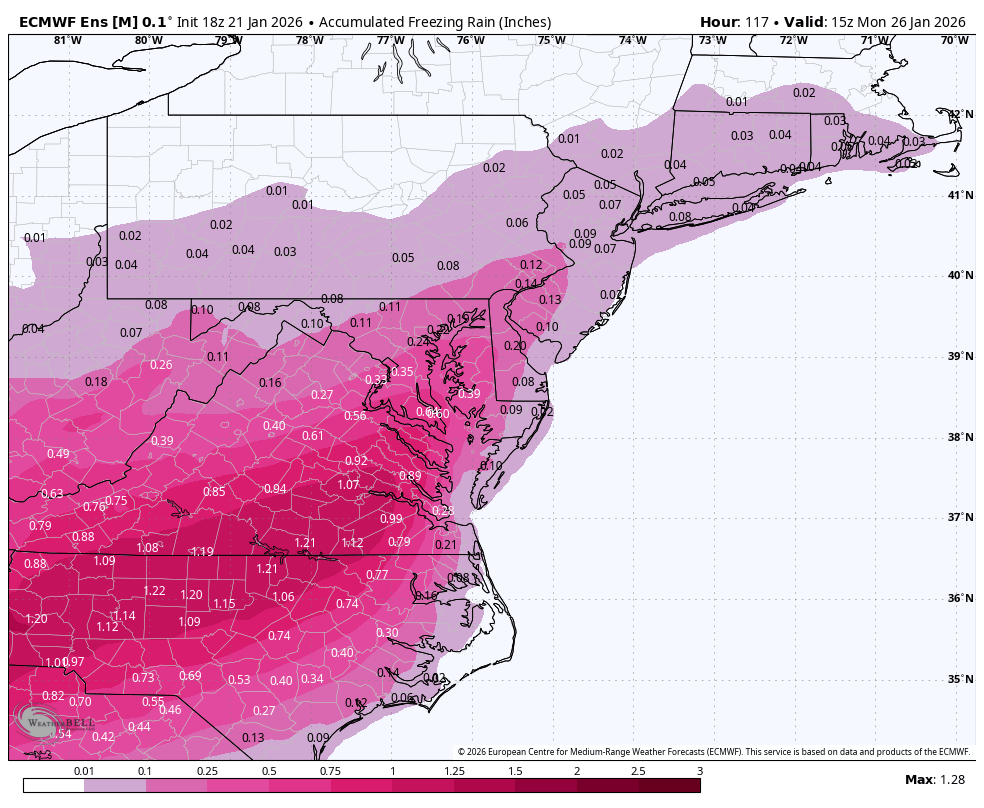
The warm layers in this case aren't really hidden at all. I mean look at this wind map lmao If we have 70-80+ kt winds from the gulf we're going to have mixing no matter how much cold air you dump into the CAD.