All Activity
- Past hour
-
Some beefy qpf showing up on some guidance. Euro has been depositing a swath of 2-4" for several runs. Might need to have the grilling get togethers Sat this year. Sunday might be a day better spent on the couch watching the US open lol.
-
Winds howling, skues clearing and temps climbing!
-
Kind of shocked we haven't seen a downstream MCD or watch extension yet
-
few days of paradise weather and then NAM selling another defo band soak job on father's day
-
Warm boundary slipping thru now... 75/68 sky light breaks 69/64 under schmutz last hr
-
Upton's changed AFD as of 11:45am: -- Changed Discussion -- Have increased wind gust potential to 40 to 35 mph for this afternoon in evening, and decreased thunderstorm coverage for late this morning into afternoon
-

2026-2027 Super El Nino
snowman19 replied to Stormchaserchuck1's topic in Weather Forecasting and Discussion
Region 3.4 is off the charts for this time of year, region 1+2 has pushed over +3C. And this is with more strong WWBs and DWKWs to come. And there’s +8C anomalies in the equatorial subsurface in the EPAC, just staggering. If the EURO Copernicus is correct, the 30C isotherm gets all the way to 140W by November, which is record breaking, totally unprecedented. The current all time record for that is 155W….. -
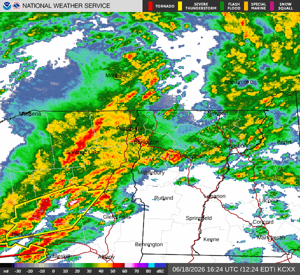
Disappointing to watch radar returns disappear once they make it to Bath or Highland county.. Looked so promising this morning only to morph into well nothing - zero raindrops- not even a decaying sprinkle...
-
Really not a worse look for the falls lake watershed
-
Seems like a flash flood threat too… we are over 1” on the day and every one of these pulses is just cranking water. Looks like there may be some training developing within the line too. I bet we can do another 1” with what’s coming.
-

Junorch obs and discussion 2026
CT Valley Snowman replied to Damage In Tolland's topic in New England
Relying on some type of renegade development on the southern flank doesn't exactly give me goosebumps. I guess we'll see what happens. -
some clearing happening now IMBY, quite breezy
-
same thing google is telling them this summer
-
mini dust storm where they are doing construction on a new development across from my house. woo drought!
-

E PA/NJ/DE Summer 2026 Obs/Discussion
Birds~69 replied to PhiEaglesfan712's topic in Philadelphia Region
76F/DP 68F at 12:30pm Hopefully a pop up boomer this afternoon... -

super el nino banter thread
JACKASS replied to forkyfork's topic in Weather Forecasting and Discussion
Absolutely!! -
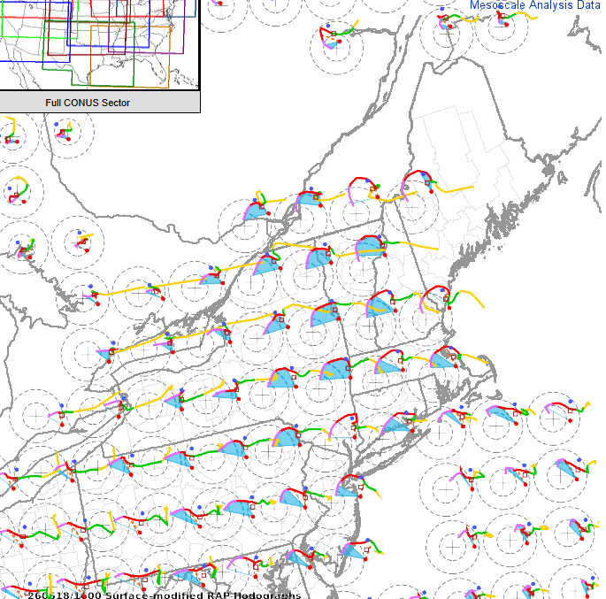
You get enough MLCAPE or 3km CAPE in this and you could be looking at the potential for a stronger tornado
-

E PA/NJ/DE Summer 2026 Obs/Discussion
LVLion77 replied to PhiEaglesfan712's topic in Philadelphia Region
It was highly detrimental to not get anything from today. My conversation was with a government friend who is a friend of somebody in the authority. They’re very worried. - Today
-
More tubes possible this weekend in IL. Record year for the State incoming?
-
Wagons north. Heading to VT.
-
More sun now - and up to 82 / 68, think we have a similar 24 hour hot day the 23-24
-
what will these people tell themselves next summer
-
0.40" round 1.
-
Clouds are back but we had a solo hour plus of sun there. Constant wind right now.
-
Sun peeking in and out here. Satellite seems about 50/50 to whether the clouds break completely


