All Activity
- Past hour
-
A top 5 warmest October for Chicago and for a lot of places. Electric bill and gas bill gonna be at a low point with these perfect temps.
-

2026-2027 Record-breaking El Nino
MJO812 replied to Stormchaserchuck1's topic in Weather Forecasting and Discussion
Judah Cohen getting excited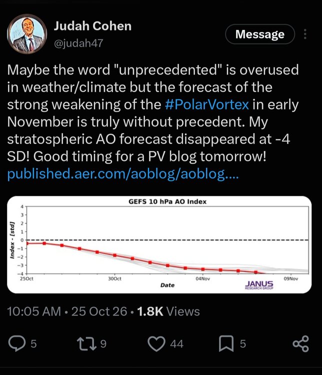
-
2026-2027 Fall/Winter Mountain Thread
Maggie Valley Steve replied to BlueRidgeFolklore's topic in Southeastern States
33 and heavy frost to the Valley floor this morning. I'm seeing some possibly big changes ahead as we enter November. It's extremely uncommon to see the models pointing to impressive Stratospheric Warming event with an elongated Polar Vortex covering the Eastern 2/3 of Canada into the United States in early November. With the usual lag time of a couple of weeks, perhaps some interesting weather ahead in time for Thanksgiving. We will see if the models are correct in the next week or so. -
37…
-
Lol Mega torch
-
-

2026-2027 Record-breaking El Nino
snowman19 replied to Stormchaserchuck1's topic in Weather Forecasting and Discussion
-
I'm not worried yet. I remember when we built our house in Calvert I had grass germinating in December and growing and that was over 20yrs ago. Things are done up here at DCL. All the leaves are down except for a few oak trees. My phone said 33F when I woke up this morning.
-

E PA/NJ/DE Autumn 2026 Obs/Discussion
MGorse replied to PhiEaglesfan712's topic in Philadelphia Region
Got down to 32F earlier this morning with a heavy frost. -
 zithromax for sale us and buy zithromax online australia zithromax 500 mg lowest price online https://www.google.co.ve/url?q=https://zpacksupply.com zithromax 250 mg tablet priceor https://armandohart.com/user/gpbksahzkj/?um_action=edit zithromax 1000 mg online [url=http://schoener.de/url?q=https://zpacksupply.com]generic zithromax over the counter[/url] zithromax buy online no prescriptionor [url=https://gikar.it/user/pdtujoddyw/]zithromax for sale usa[/url] generic zithromax india
-
2026-2027 Record-breaking El Nino
snowman19 replied to Stormchaserchuck1's topic in Weather Forecasting and Discussion
We are 100% on the same page. This background state is extremely hostile to major SSWEs and a sustained weak SPV….lack of a strong MJO 6, 7, 8 propagation (due to the historic El Niño), the very strong low frequency Nino forcing is totally overwhelming and muting the MJO signal, as is typical for super events, a downwelled, very strong and still strengthening +QBO, descending solar off last year’s solar max, high geomag, +IOD……. -
32F for the low. Must've been a pretty heavy frost, everything was wet when I went outside.
-
Another day in paradise
-
zithromax for sale us and buy zithromax online australia zithromax 500 mg lowest price online https://www.google.co.ve/url?q=https://zpacksupply.com zithromax 250 mg tablet priceor https://armandohart.com/user/gpbksahzkj/?um_action=edit zithromax 1000 mg online [url=http://schoener.de/url?q=https://zpacksupply.com]generic zithromax over the counter[/url] zithromax buy online no prescriptionor [url=https://gikar.it/user/pdtujoddyw/]zithromax for sale usa[/url] generic zithromax india
-

October 2026 general discussion
Prismshine Productions replied to Typhoon Tip's topic in New England
Because it is all locked up north, ice cap already over 7.2m km². Sent from my SM-S176V using Tapatalk - Today
-

Yellow Medicine County, MN - Climate Fact or Climate Fiction?
ChescoWx replied to Cobalt's topic in Climate Change
Sorry Don but the concentration of daily highs were by far occurring before 2000 across all locations! Most of Yellow Medicine’s daily record highs were set before 2000: about three-quarters before 2000 and about 90% before 2020. This counts all 366 calendar dates in the raw station data through 2025. Before 2000 Before 2020 Canby (in county, 1916–2025) 76% 91% Area, all 6 stations (1893–2025) 73% 89% Area without Granite Falls 75% 91% Canby’s records show about 75% of its years are before 2000, and 76% of its records were set then. About 94% of its years are before 2020, and 91% of its records were set then. That points to no clear trend toward more record highs. By decade, the 1930s dominate: they hold about 70 of the 366 area daily records, nearly twice any other decade. Canby alone has 72 from the 1930s, against 40 from the 1980s and 32 from the 2020s. Don Granite Falls exaggerates records as in fact that station only has temperatures for 1893–1897 and then not again until 2007. These are the days with a high temperature reported each year: Years Temperature Precipitation 1893–1896 Nearly complete (317–355 days a year) Yes 1897 61 days, then it stops Partial 1898–1947 None None 1948–1951 None Yes 1991–2006 None Yes, with gaps 2007–2025 Complete Yes -

2026-2027 Record-breaking El Nino
mitchnick replied to Stormchaserchuck1's topic in Weather Forecasting and Discussion
Cfs2, fwiw, has been advertising a little AN December, but not a blow torch. -
 Well if we have a legit Stratosphere warming, the average lag in early Nov to effect the AO the greatest is +35-40 days. That's about mid December and could certainly make these blowtorch December forecasts a little less likely.
-
Didn't it inject massive amounts of water vapor into the strat?
-
Climo first freeze for you is probably Nov 1-ish? Couple days earlier for me? IAD is behind schedule. But with the early November forecast, probably most of us that haven’t had a freeze yet will be later than normal.
-
October 25 1887: Albert Lea sets a record low of -6 degrees F. 1830: A 'heat wave' hits Ft. Snelling. The high temperature reached 80. For Sunday, October 25, 2026 1921 - A hurricane with 100 mph winds hit Tampa, FL, causing several million dollars damage. (David Ludlum) 1977 - Dutch Harbor in Alaska reported a barometric pressure reading of 27.31 inches (925 millibars) to establish an all-time record for the state. (The Weather Channel) 1981 - A northbound tornado caused two million dollars damage to Bountstown, FL, in less than five minutes. Fortunately no deaths occurred along its six mile path, which was 30 to 100 yards in width. Radar at Apalachicola had no indication of a tornado or severe weather. (The Weather Channel) 1987 - A storm system moving across the Saint Lawrence Valley produced 40 to 50 mph winds east of Lake Ontario. High winds downed some trees around Watertown NY, and produced waves seven feet high between Henderson Harbor and Alexandria Bay. Mason City IA and Waterloo IA tied for honors as cold spot in the nation with record lows for the date of 19 degrees. Severe thunderstorms in Oklahoma and northern Texas produced golf ball size hail and wind gusts to 65 mph. (The National Weather Summary) (Storm Data) 1988 - Severe thunderstorms erupted over northeastern Texas during the late evening producing softball size hail at Newcastle and Jonesboro. Low pressure over James Bay in Canada continued to produced showers and gale force winds in the Great Lakes Region. (The National Weather Summary) (Storm Data) 1989 - Low pressure over Nevada produced high winds in the southwestern U.S., and spread heavy snow into Utah. Winds gusted to 63 mph at the Mojave Airport in southern California. Snowfall totals in Utah ranged up to 12 inches at Snowbird, with 11 inches at Alta. "Indian Summer" type weather continued in the central and eastern U.S. Twenty cities in the north central U.S. reported record high temperatures for the date. Highs of 77 degrees at Alpena MI and 81 degrees at Saint Cloud MN were the warmest of record for so late in the season. (The National Weather Summary) (Storm Data) Observances: 25 Sun World Pasta Day 25 Sun National Art Day 25 Sun National I Care About You Day 25 Sun National Mother-in-Law Day 25 Sun International Artist Day 25 Sun International Dwarfism Awareness Day 25 Sun World Opera Day 25 Sun National Chucky Day 25 Sun National Fine Art Appreciation Day 25 Sun National Greasy Foods Day 25 Sun National Hope for Henry Day 25 Sun Punk For A Day Day 25 Sun Sourest Day
-
33 and frosty
-
Yes the fog rolled in here too on top of the hard frost.
-
Little foggy out there .
-

Yellow Medicine County, MN - Climate Fact or Climate Fiction?
donsutherland1 replied to Cobalt's topic in Climate Change
At Granite Falls, MN, county capital for Yellow Medicine County, 84% of daily record high temperatures were set or tied since 2000 and 43% were set or tied since 2020. In addition, 83% of monthly record highs were set or tied since 2000 and 50% of monthly record highs were set or tied since 2020. Climate records go back to January 1893. The concentration of record highs in recent decades is substantial and consistent with a warming climate, as documented in the NCEI data.