All Activity
- Past hour
-
.thumb.jpg.6a4895b2a43f87359e4e7d04a6fa0d14.jpg)
Central PA Summer 2026 Discussion/Obs Thread
Yardstickgozinya replied to Voyager's topic in Upstate New York/Pennsylvania
Excessive Rainfall Discussion NWS Weather Prediction Center College Park MD 417 AM EDT Sat Jul 4 2026 Day 2 Valid 12Z Sun Jul 05 2026 - 12Z Mon Jul 06 2026 ...THERE IS A SLIGHT RISK OF EXCESSIVE RAINFALL ACROSS PORTIONS OF THE MID-ATLANTIC... An east-west orientated front boundary will be sprawled across the Northeast/northern Mid-Atlantic region during this period. Moderate instability combined with PW values of 2+ inches are expected to overlap near the frontal boundary to produce periods of heavy rainfall. This area historically is more prone to flash flooding due to terrain influences and more sensitive hydrologic schemes thus maintaining the Slight Risk for excessive rainfall for this part of the region. Backbuilding and training of thunderstorms may be possible. Scattered flash flood concerns exist over the central Mid- Atlantic with an increasing risk of heavy convection over portions of Pennsylvania down through the Washington DC- Baltimore- Philadelphia corridor. A broad Marginal Risk area spans from eastern Oklahoma/Kansas eastward to the Mid- Atlantic/southern portions of the Northeast. -
Probably good thing we dont have shear near 40 kts .DISCUSSION... KEY MESSAGE 1...A highly impactful Independence Day lies ahead today with extreme heat and an Enhanced Risk for severe thunderstorms. Anomalous heat and humidity remain a fixture across the area. Based on the latest 07Z/3 AM observational data, temperatures generally range from the mid 70s to mid 80s. This is accompanied by dew points in the 70s which is yielding overnight heat indices between 85 to 95 degrees. Skies remain mostly clear although there is still residual convective debris drifting southward from central Pennsylvania. Before convection enters the picture, it will be another day of record warmth across the Mid-Atlantic region. Using 850-mb temperatures as a proxy, forecast readings should be around 22-23C which dry adiabatic mixing favors another 100 degree day. Adding continued tropical moisture in place will support heat indices pushing into the 105 to 110 degree range. Extreme Heat Warnings are in effect from 10 AM until 9 PM for areas east of the Blue Ridge. Given an uptick in forecast heat indices, have upgraded to warnings over north-central Maryland down across the eastern West Virginia Panhandle into portions of the Shenandoah Valley. Otherwise, outside of mountain locations, Heat Advisories will be in effect until 8 PM this evening. Unlike previous days which were free of convection, a collapsing ridge will lift the subsidence that has persisted the last few days. Although mid/upper heights remain anomalous in nature, forcing from an approaching shortwave will aid in more widespread showers and thunderstorms. One unique aspect to the thermodynamic environment is an elevated mixed layer (EML) which has shown up in the last 4 IAD sounding profiles. Within this layer around 750-600 mb, lapse rates continue to run between 8-9 C/km which is unusually steep for this area. This is contributing to some impressively large amounts of instability, generally in the 3,000 to 4,000 J/kg. Within the deeply mixed boundary layer, substantial downdraft CAPE (DCAPE) is evident with values around 1,300 to 1,700 J/kg. Although vertical shear is only around 20 to 25 knots, any storms able to tap into the robust instability will be capable of damaging winds. Some of this could be locally destructive with gusts up to 60 to 75 mph. With all of the above in mind, and ample high-resolution model support, the Storm Prediction Center has upgraded areas east of the Blue Ridge to an Enhanced Risk today. This upgrade would support a more widespread footprint of severe thunderstorms this afternoon and evening. Looking a bit more closely at today`s setup, convective initiation likely will be more mesoscale in nature. This would include the climatological lee-side trough, bay and river breezes, as well as any remnant outflows from earlier convection. Multiple rounds of thunderstorms are possible given so much instability in the troposphere. The primary signal east of the Blue Ridge is in the 3-9 PM timeframe, slightly earlier to the west. Damaging to locally destructive winds are the main threat, with any chance for large hail being minimal given the summertime freezing levels. Although the convective signal is strongest during the afternoon to early evening hours, residual storms could easily impact those with outdoor plans for fireworks this evening. Continue to check back at weather.gov/lwx or follow the National Weather Service - Baltimore/Washington social media accounts for the latest.
-
 So much for his Stein and a couple showers lolz
 -
 Need to get some of that up here. This will hurt. Congrats Ditty on 5+
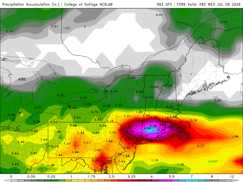
-
Holy *bleep* just woke up to 80.6 degrees. It never got below 80 last night!
-
.thumb.gif.f92b16c631a1d15d405ed77b33f0710d.gif) maybe 6-12" for a swath? NYC SW CT?
maybe 6-12" for a swath? NYC SW CT? -

2026-2027 Super El Nino
bluewave replied to Stormchaserchuck1's topic in Weather Forecasting and Discussion
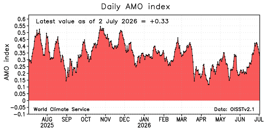
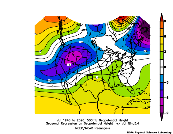
We have been experiencing record heat here in the East at times going back to March related to the record breaking subtropical tropical ridges from 30N to 45N. Most times very strong to super El Niños feature more troughs and low pressure at these latitudes. The ridges are usually further north on the continent in Canada. This has lead to the mid-latitude Atlantic joining the very warm mid-latitude Pacific. This is probably related to the ongoing expansion of the subtropical ridges over the years. Plus we have very extensive drought in the CONUS at this time. Also when forcing shifts back to the IO and MC we tend to see the peak warmth and ridging in the East. The reason the -PDO and +AMO has been so persistent in recent years is due to these strong ridges leading to lighter winds and more sunshine warming the ocean surface below.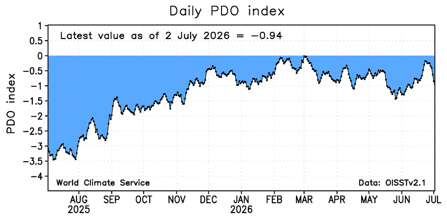
-
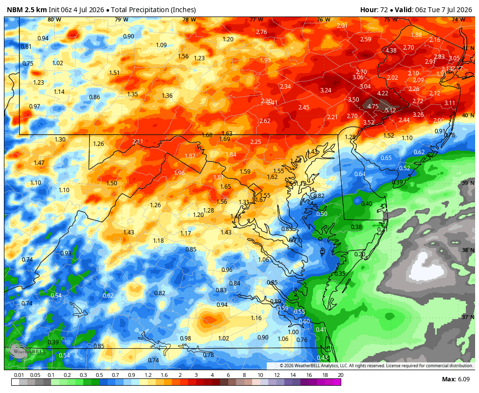
WB 6Z NBM Day 3 precip. Totals.

-
Central PA Summer 2026 Discussion/Obs Thread
Yardstickgozinya replied to Voyager's topic in Upstate New York/Pennsylvania
NWS verbatim SPC on today's severe potential. -- Highlight Changed Discussion -- 237 FXUS61 KCTP 040916 AFDCTP Area Forecast Discussion National Weather Service State College PA 516 AM EDT Sat Jul 4 2026 .WHAT HAS CHANGED... * Extreme Heat Warning upgrade for Fulton, Franklin, Perry, and Cumberland Counties && .KEY MESSAGES... 1) Breakdown of early July heat wave promotes an increased risk of damaging thunderstorm wind gusts and potential flash flooding through Independence Day weekend && .DISCUSSION... KEY MESSAGE 1: Breakdown of early July heat wave promotes an increased risk of damaging thunderstorm wind gusts and potential flash flooding through Independence Day weekend Final day of heat headlines with max heat indices reaching 100-110 degrees to the east of the Allegheny Plateau. The breakdown or ending process of heat waves is often marked by bouts of severe weather - and that will likely hold true through the July 4th holiday weekend. Clusters of storms are projected to develop through the weekend in a very moist, unstable, modestly sheared environment and will have the potential to produce localized to perhaps widespread damaging wind gusts - especially of they can grow upscale and sustain strong cold pools. A threat for heavy to excessive rainfall will also be in play given high pwats and efficient rainfall/hourly rates. SPC and WPC outlooks were largely unchanged for this cycle. https://forecast.weather.gov/product.php?site=CTP&issuedby=CTP&product=AFD&format=CI&version=1&glossary=1&highlight=off -
 Looks decent for CT. Latest HRRR suggests a small bowing segment 7-9pm.
 -
68.3 after 100.3 at 5:30 yesterday.
-
Central PA Summer 2026 Discussion/Obs Thread
Yardstickgozinya replied to Voyager's topic in Upstate New York/Pennsylvania
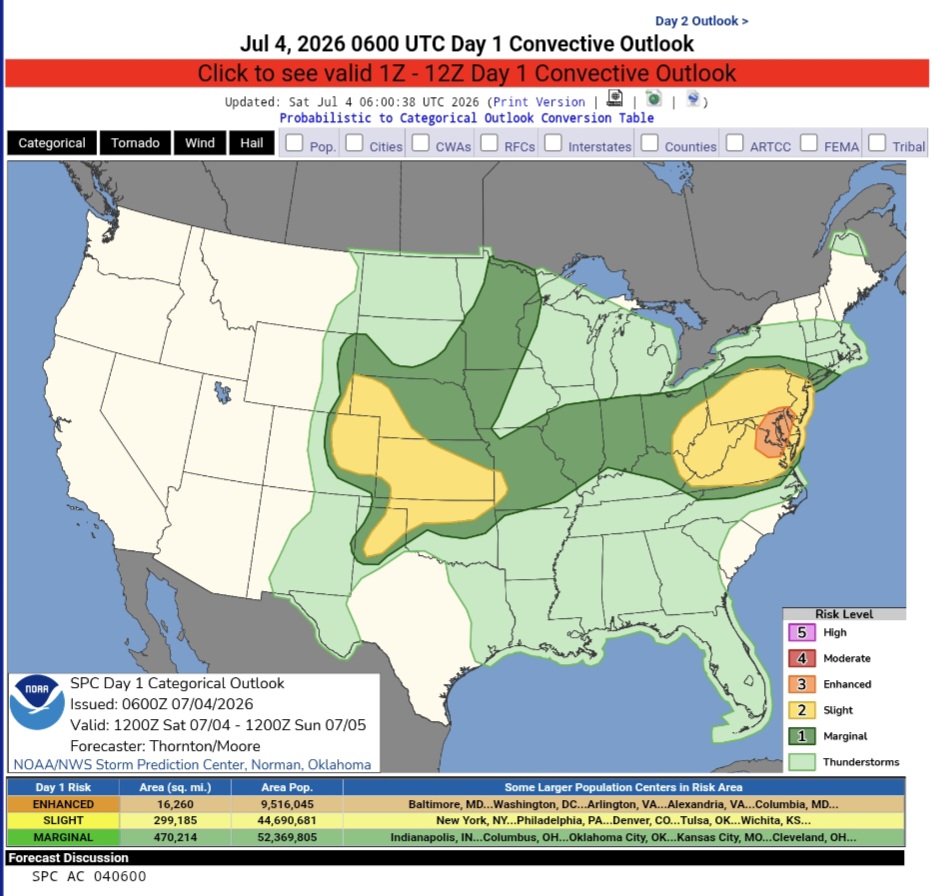
Happy Independence to those who acknowledge the United States is the greatest country in the world ,and all those who serve and have served America. Stay safe out there, especially, you extreme southeastern folk. Day 1 Convective Outlook NWS Storm Prediction Center Norman OK 0100 AM CDT Sat Jul 04 2026 Valid 041200Z - 051200Z ...THERE IS AN ENHANCED RISK OF SEVERE THUNDERSTORMS PORTIONS OF THE MID-ATLANTIC... ...THERE IS A SLIGHT RISK OF SEVERE THUNDERSTORMS ACROSS PORTIONS OF THE CENTRAL/SOUTHERN PLAINS... ...SUMMARY... Clusters of storms will move across parts of the Allegheny Plateau into Mid Atlantic, with potential for widespread damaging wind. Additional thunderstorms are expected across the Great Plains Saturday afternoon and evening, posing a risk for damaging wind gusts. Large hail is also possible across the Great Plains. ...Synopsis... Height rises will continue across the western US, with more zonal flow across the central US and upper-level troughing across the Northeast and Quebec/Ontario. A modest belt of westerly flow around 30-40 kts will move through the trough in the Northeast/Mid-Atlantic. A compact shortwave trough with enhanced westerly flow will move through the flow across the Central Plains. ...Eastern Ohio Valley into the Mid-Atlantic... Activity will likely be ongoing across some portion of northern PA into northern NJ this morning. This will likely contribute to lingering cloud cover and more muted daytime heating/recovery with northern extent. South of the morning precipitation, strong daytime heating and warming is expected, with temperatures climbing into the 90s to 100s F. A plume of steep mid-level lapse rates is already in place across the region from WV into VA/MD/NJ. With daytime heating, low-level lapse rates are expected to increase with moderate to strong instability by the afternoon. Deep layer shear profiles will be generally weak, with better shear to the north. Nonetheless, several thunderstorm clusters are expected to develop across the Blue Ridge Mountains/Shenandoah Valley moving north and eastward though the afternoon. These will have the potential to produce widespread damaging wind, especially if clusters can grow upscale and develop strong cold pools. https://www.spc.noaa.gov/products/outlook/day1otlk.html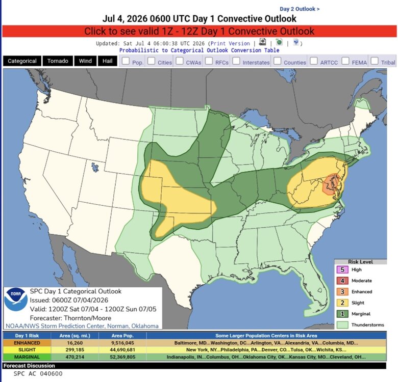
-
 Today looks pretty meh in the heat department. Progged SW will keep it comfy. Maybe I can convince my wife to open the windows.
 -
75.9/70/77 right now.
-
 How do storms look later today?
 -
In the latest AFD from LWX... National Weather Service Baltimore MD/Washington DC 400 AM EDT Sat Jul 4 2026 .WHAT HAS CHANGED... Given an uptick in today`s heat index forecast, have upgraded to Extreme Heat Warnings across north-central Maryland down across the eastern West Virginia Panhandle into the Shenandoah Valley. For today`s convective threat, the Storm Prediction Center has upgraded to an Enhanced Risk for severe thunderstorms across locations east of the Blue Ridge Mountains. (snip) Before convection enters the picture, it will be another day of record warmth across the Mid-Atlantic region. Using 850-mb temperatures as a proxy, forecast readings should be around 22-23C which dry adiabatic mixing favors another 100 degree day. Adding continued tropical moisture in place will support heat indices pushing into the 105 to 110 degree range. Extreme Heat Warnings are in effect from 10 AM until 9 PM for areas east of the Blue Ridge. (snip) Although vertical shear is only around 20 to 25 knots, any storms able to tap into the robust instability will be capable of damaging winds. Some of this could be locally destructive with gusts up to 60 to 75 mph. (snip) The primary signal east of the Blue Ridge is in the 3-9 PM timeframe, slightly earlier to the west. Damaging to locally destructive winds are the main threat, with any chance for large hail being minimal given the summertime freezing levels. (snip)
- Today
-
 Lots of spread on ensembles. Will be a very narrow area . Rest of the area will just be meh
 -

Fireworks Heat Contest W 7/1 - S 7/4 for Five MA Airports
nw baltimore wx replied to nw baltimore wx's topic in Mid Atlantic
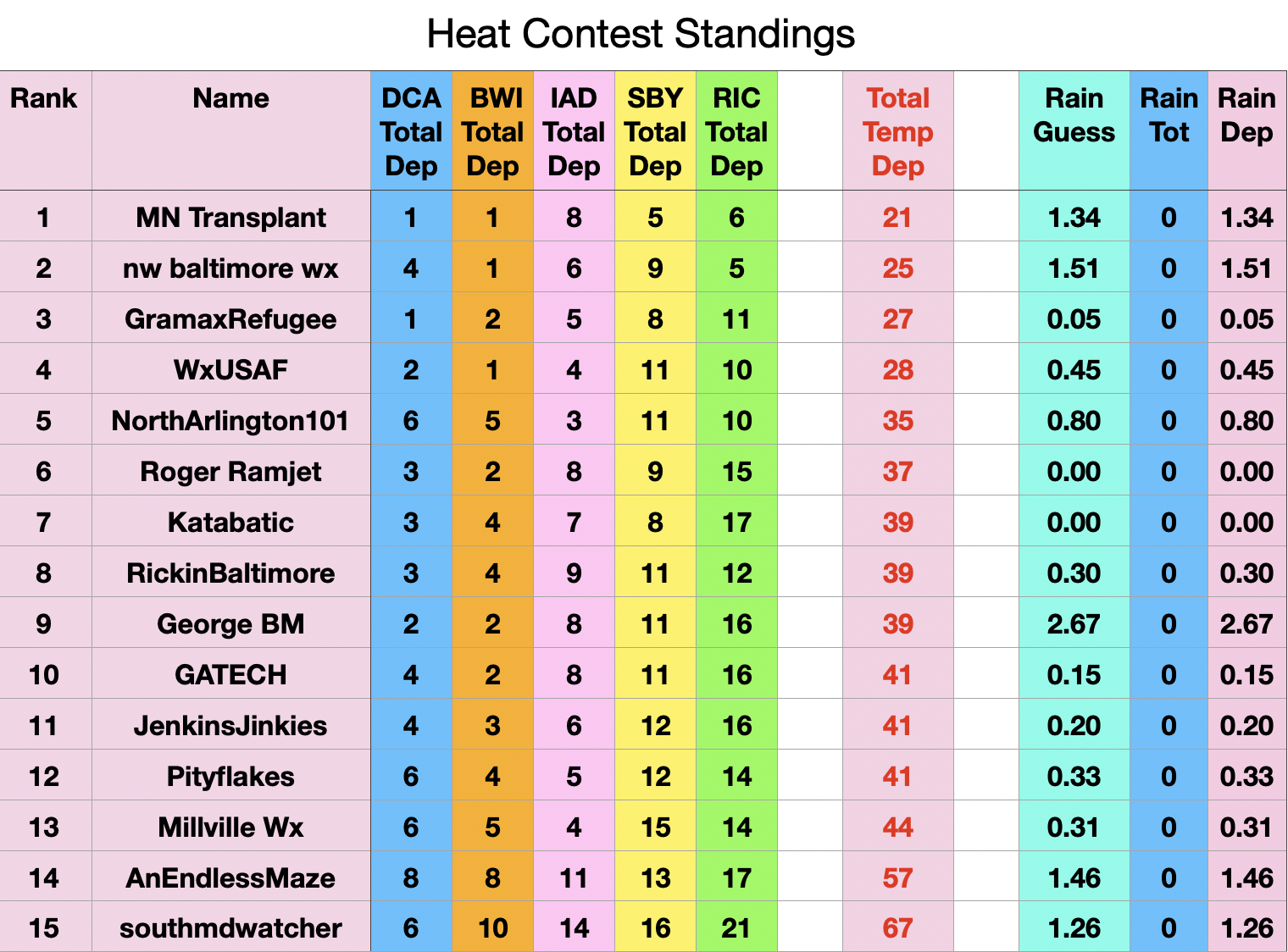
The high temps used for Friday, 7/3, are: DCA 102, BWI 102, IAD 98, SBY 101, and RIC 99. I'd appreciate anyone checking that I am accurate, and if so, these are the current standings.
-
They were moving east to west earlier then started moving S to N. My current forecast is dry tomorrow but you guys may have a better shot at storms.
-
I was actually at Turkey Creek in a movie and it thundered there and had rained when I came out. East of there was drier and I got back here as the storm was hitting hard. It moved S to N.
-
The amount of rain, thunder and cloud to ground lightning earlier tonight was absolutely wonderful
-
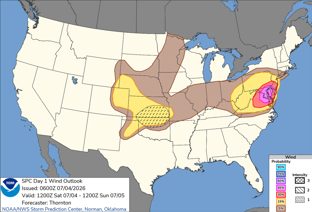
SPC has an ENH 45% for wind over parts of the region. While DCAPE is good, overall tstm coverage does not suggest widespread high winds. And deep layer wind shear is weak so you will not likely have organized short bow or line segments moving rapidly in one direction. This does not mean any wind event will not be significant or very damaging locally, but you do not need ENH for that. You do not need even SLGT, as low svr probs say nothing about the intensity of any given individual svr event in the outlook area. 30% for wind objectively seems better. The ENH and 45% area almost bisects much of Chesapeake Bay. I have to think due to it being the 4th of July, DC, and 250 events, the ENH is due to this. I have no proof of course, but let's honest w/ ourselves. I have pointed out before there is an odd bulls-eye for frequency of svr tstm watch center over the DC area. That's is not likely due to climo. The social/economic/political do influence alerts/watches/warnings at times. .
-
Day 1 Convective Outlook NWS Storm Prediction Center Norman OK 0100 AM CDT Sat Jul 04 2026 Valid 041200Z - 051200Z ...THERE IS AN ENHANCED RISK OF SEVERE THUNDERSTORMS PORTIONS OF THE MID-ATLANTIC... ...THERE IS A SLIGHT RISK OF SEVERE THUNDERSTORMS ACROSS PORTIONS OF THE CENTRAL/SOUTHERN PLAINS... ...SUMMARY... Clusters of storms will move across parts of the Allegheny Plateau into Mid Atlantic, with potential for widespread damaging wind. Additional thunderstorms are expected across the Great Plains Saturday afternoon and evening, posing a risk for damaging wind gusts. Large hail is also possible across the Great Plains. ...Synopsis... Height rises will continue across the western US, with more zonal flow across the central US and upper-level troughing across the Northeast and Quebec/Ontario. A modest belt of westerly flow around 30-40 kts will move through the trough in the Northeast/Mid-Atlantic. A compact shortwave trough with enhanced westerly flow will move through the flow across the Central Plains. ...Eastern Ohio Valley into the Mid-Atlantic... Activity will likely be ongoing across some portion of northern PA into northern NJ this morning. This will likely contribute to lingering cloud cover and more muted daytime heating/recovery with northern extent. South of the morning precipitation, strong daytime heating and warming is expected, with temperatures climbing into the 90s to 100s F. A plume of steep mid-level lapse rates is already in place across the region from WV into VA/MD/NJ. With daytime heating, low-level lapse rates are expected to increase with moderate to strong instability by the afternoon. Deep layer shear profiles will be generally weak, with better shear to the north. Nonetheless, several thunderstorm clusters are expected to develop across the Blue Ridge Mountains/Shenandoah Valley moving north and eastward though the afternoon. These will have the potential to produce widespread damaging wind, especially if clusters can grow upscale and develop strong cold pools. Additional clusters are likely in the wake of morning convection further north. Instability will be less, but sufficient deep layer shear may support one or more clusters capable of damaging wind.
-
88/74/96 at 3am at DCA... toasty
-
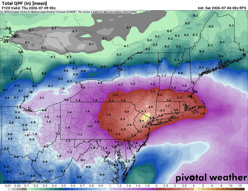
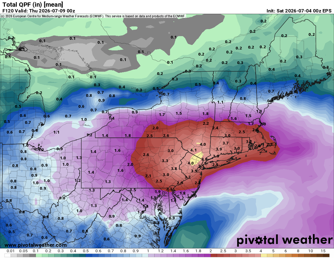
 Pretty high amounts on the EPS.. good sign someone is going to get crushed