All Activity
- Past hour
-
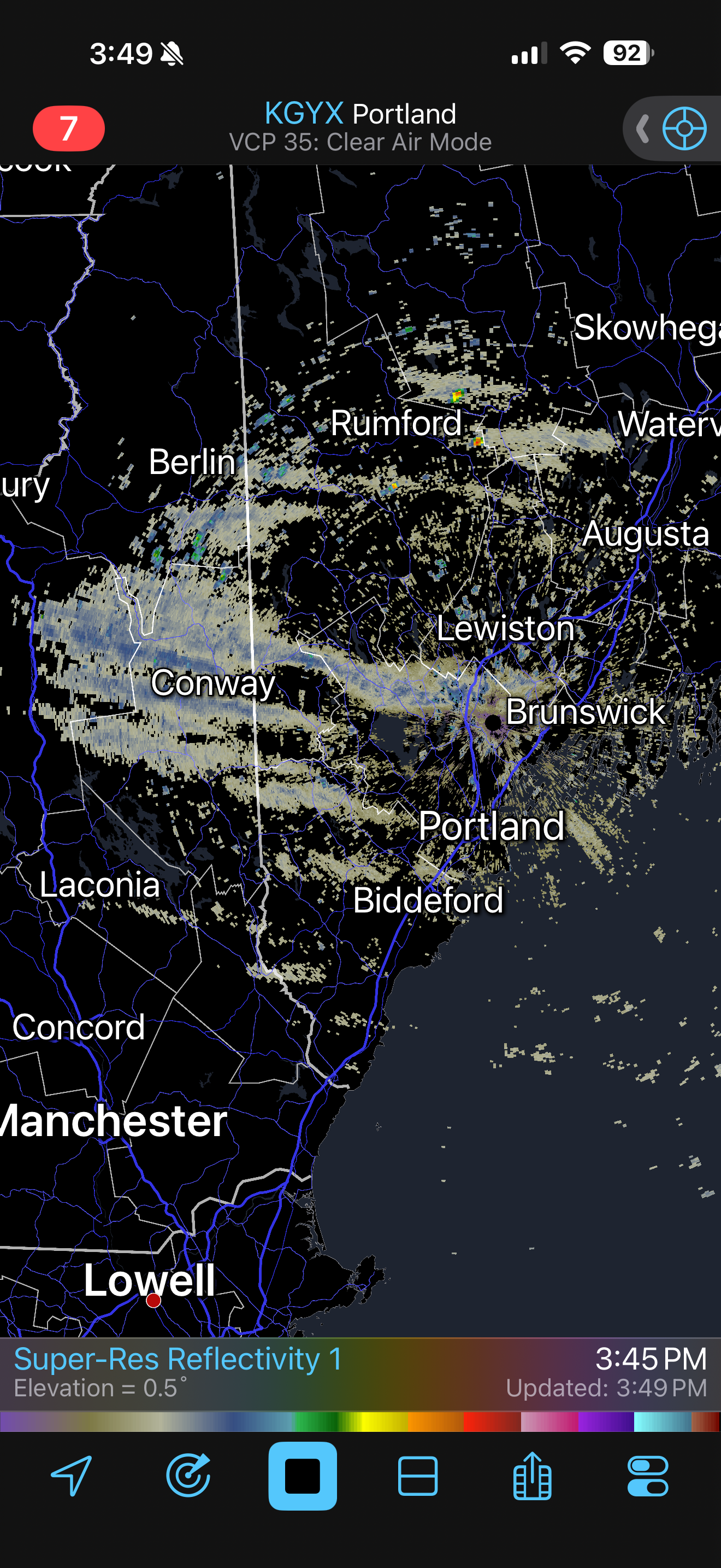
A few streamers moving thru the lakes region

-
I could see that 12-18" panning out near the lakeshore in far NE OH, especially in northern Ashtabula County, but Geauga County won't get that much IMO. The downside of grouping multiple counties together in a warning. It just seems like there will be too much of a break after snow lifts out of there tonight, and I think stuff will progress through too quickly with the cold front tomorrow evening. There's definitely a shot Geauga County verifies a warning at some point (they haven't yet...) but the 12-18" feels inflated there. We'll see, as I've been wrong before. Nice band ongoing at the moment.
-
Wouldn’t surprise me if east end of li ends up with 2”
-

New Years Day 2026 - 1st snows of the new year possible
ORH_wxman replied to Baroclinic Zone's topic in New England
Seems like most should get measurable but 2”+ will probably be in isolated pockets or out on/near Cape. -
Neither the GFS nor the EURO have meaningful QPF in central NC until January 14!
-
You either leave happy with a buzz, Or you leave pretty intoxicated............
-

New Years Day 2026 - 1st snows of the new year possible
klw replied to Baroclinic Zone's topic in New England
Can we wait until 2026 starts before we comment about how lame the year has been so far? -
I’m calculating that the Dec NAO will come in near -1, easily the most negative Dec since 2010. This is the first moderate to strong Dec -NAO during active Dec sunspots since 2002, when sunspots were 135. I’m estimating Dec of 2025 SSN to be 120.
-
good. If you are floundering in your attempts to catch anything, just don't sit there carping about it.
-

New Years Day 2026 - 1st snows of the new year possible
SJonesWX replied to Baroclinic Zone's topic in New England
i am really looking forward to my 0.5" awesome -

New Years Day 2026 - 1st snows of the new year possible
dryslot replied to Baroclinic Zone's topic in New England
These have had surprises over the past years once they hit the Atlantic they can develop rapidly. -

Central PA Winter 25/26 Discussion and Obs
Mount Joy Snowman replied to MAG5035's topic in Upstate New York/Pennsylvania
Saw that, and still ranting about the performance of the models. I also saw he openly admitted to preferring warm weather and said he doesn't root for big snowstorms. Alrighty then. -

New Years Day 2026 - 1st snows of the new year possible
TauntonBlizzard2013 replied to Baroclinic Zone's topic in New England
Yeah, NAM is a good illustration how this may play out. Couple inches for SE Mass and Downeast Maine. Flurries elsewhere. If it could get going even 6 hours earlier, could get more involved -

January 2026 regional war/obs/disco thread
weatherwiz replied to Baroclinic Zone's topic in New England
It does have that look to it. -

January 2026 regional war/obs/disco thread
Typhoon Tip replied to Baroclinic Zone's topic in New England
The GEFs version above looks like a bit of an undercutting/split flow... -

E PA/NJ/DE Winter 2025-26 Obs/Discussion
penndotguy replied to LVblizzard's topic in Philadelphia Region
Meh, give it 24 hrs and it’ll show something different. -
January 2026 regional war/obs/disco thread
weatherwiz replied to Baroclinic Zone's topic in New England
It's definitely an extremely intriguing look and what I like about it is this type of pattern opens the door for some southern stream involvement and that would at least offer some potential for a bigger storm. But why I also love the Jan 10-15 period is we may see a relaxing NAO during that period, or the NAO becoming less negative and at the same time we're seeing variations within the state of the PNA. The pattern will not be void of energy and storm chances. If we want to add another layer to this is we will have the PV displaced on our side of the hemisphere. -

New Years Day 2026 - 1st snows of the new year possible
Damage In Tolland replied to Baroclinic Zone's topic in New England
It’s very easy to look at literally every model and see steady light snow shown on all of them . All for a 1-4” event from west to east. Not rocket science -

Winter 2025-26 Short Range Discussion
sbnwx85 replied to SchaumburgStormer's topic in Lakes/Ohio Valley
3-6" over two days, but it'll be so fluffy it'll compact to 2" real quick. -
At least half of that is 1/1, although I'd be happy with a fresh coating each day...
-

12/31-1/1 Possible Snow Showers/Squalls to Start 2026
WxUSAF replied to bncho's topic in Mid Atlantic
Looks like a top 3 snow event of the season for MBY! -

Central PA Winter 25/26 Discussion and Obs
GrandmasterB replied to MAG5035's topic in Upstate New York/Pennsylvania
“Here's a BIG reason to be skeptical of a monster snowstorm in the mid-Atlantic States through mid-Jan…” -MU Incredibly bold call to predict no “monster” snowstorms in the next two to three weeks. -

12/31-1/1 Possible Snow Showers/Squalls to Start 2026
IronTy replied to bncho's topic in Mid Atlantic
I'm hoping for a dusting so I can't get to work tomorrow since I'm supposed to go onsite. -
January 2026 regional war/obs/disco thread
TauntonBlizzard2013 replied to Baroclinic Zone's topic in New England
Hey. Positive vibes only I guess. It snows in people’s hopes and dreams, rarely in reality and on the models, where it actually matters,over the last half decade or so -
New Years Day 2026 - 1st snows of the new year possible
dryslot replied to Baroclinic Zone's topic in New England
18z Nam really blows this low up towards DE Maine down to 987mb dropping a foot there, May watch this to see if this can happen a bit sooner in the next 24hrs, That would at least get some accumulating snow further west but as of now, Its a bit to late for most, Nothing else better to do.........lol