All Activity
- Past hour
-
Looks like the Niña/-IOD standing wave has set up
- Today
-

Fall/Winter Banter - Football, Basketball, Snowball?
John1122 replied to John1122's topic in Tennessee Valley
That was a tough loss. We've not had such a painful FG miss since 2010 vs Alabama, and that one was blocked. Team looked better than I expected on offense, but man, gotta make that kick. -
Looks brutal this week.. Detailed Forecast Overnight Patchy fog after 5am. Otherwise, partly cloudy, with a low around 53. Calm wind. Sunday Patchy fog before 7am. Otherwise, mostly sunny, with a high near 76. Calm wind becoming northwest around 6 mph in the afternoon. Sunday Night Mostly clear, with a low around 51. Calm wind. Monday Sunny, with a high near 76. Light northeast wind. Monday Night Mostly clear, with a low around 50. Light and variable wind. Tuesday Sunny, with a high near 76. Light and variable wind. Tuesday Night Mostly clear, with a low around 50. Calm wind. Wednesday Mostly sunny, with a high near 76. Calm wind becoming southwest around 5 mph in the afternoon. Wednesday Night Mostly cloudy, with a low around 52. Calm wind. Thursday Partly sunny, with a high near 77. Calm wind becoming southwest around 6 mph in the afternoon. Thursday Night Partly cloudy, with a low around 55. Light south wind. Friday Sunny, with a high near 78. Northwest wind 5 to 8 mph. Friday Night Mostly clear, with a low around 48. North wind around 6 mph. Saturday Mostly sunny, with a high near 67. North wind around 7 mph.
-
For 60% orange in MDR 0Z UKMET: TS in middle of ocean again NEW TROPICAL CYCLONE FORECAST TO DEVELOP AFTER 96 HOURS FORECAST POSITION AT T+ 96 : 16.4N 45.5W LEAD CENTRAL MAXIMUM WIND VERIFYING TIME TIME POSITION PRESSURE (MB) SPEED (KNOTS) -------------- ---- -------- ------------- ------------- 1200UTC 17.09.2025 96 16.4N 45.5W 1005 41 0000UTC 18.09.2025 108 17.6N 47.7W 1005 45 1200UTC 18.09.2025 120 19.7N 49.9W 1006 44 0000UTC 19.09.2025 132 20.6N 51.6W 1006 40 1200UTC 19.09.2025 144 21.4N 53.0W 1005 36 0000UTC 20.09.2025 156 22.5N 53.5W 1004 46 1200UTC 20.09.2025 168 22.9N 55.4W 1002 45
-
That’s a pretty low bar
-
It should be a more exciting winter for most of SNE than last winter.
-

September 2025 OBS-Discussion centered NYC subforum
psv88 replied to wdrag's topic in New York City Metro
77 today. Light showers now -

2025-2026 ENSO
40/70 Benchmark replied to 40/70 Benchmark's topic in Weather Forecasting and Discussion
https://easternmassweather.blogspot.com/2025/08/preview-of-extra-tropical-pacific-for.html https://easternmassweather.blogspot.com/2025/08/preview-of-polar-domain-for-winter-2025.html -
I think that is a given.
-
Needed more wind or more fair weather cumulus. But a 9/10 day. Gulf Stream low getting pulled north looks interesting coming into the weekdays.
-
Simply sublime. Wife and I went for a hike/walk around Beverly-Triton State Park and it was absolutely immaculate out. Temps in the mid-70s with a breeze off the Bay. Honestly couldn't ask for much better.
-
Nothing here this morning, unless I slept through it.
-
Today’s weather was a dime…possibly the nicest day of the year.
-

September 2025 OBS-Discussion centered NYC subforum
SACRUS replied to wdrag's topic in New York City Metro
Highs: TEB: 83 PHL: 83 New Brnswck: 82 TTN: 82 EWR: 79 ACY: 78 LGA: 77 NYC: 77 ISP: 76 BLM: 75 JFK: 75 -
Low of 63, high of 80. This incredible September weather is sure welcomed but we could use some rain
-

Occasional Thoughts on Climate Change
donsutherland1 replied to donsutherland1's topic in Climate Change
Greenland saw a significant rain event this year. From the NSIDC: Substantial rainfall reached the South Dome (SDM) weather station at an elevation of 2,895 meters (9,498 feet) above sea level, with more than 30 millimeters (1 inch) recorded at the SDM weather station on August 14 and 15, per Denmark’s Programme for Monitoring of the Greenland Ice Sheet (PROMICE) (Figure 3b). This is an exceptional amount of rain at this altitude. A similar amount of rain, 29 millimeters (1.14 inches) over August 14 and 15, was also recorded above Nuuk at the NUK_U weather station, at an elevation of 1,122 meters (3,680 feet). In later warm-front pulses during the melt event, the weather station at Swiss Camp recorded 4 millimeters (0.16 inches) of rain on August 18. Earlier, the Swiss Camp station recorded 10 millimeters (0.4 inches) of rain during the mid-July melt event. The first important rain event observed at Summit Station occurred on August 14, 2021. Both rain and surface melting occurred at the same location. -

2025 Atlantic Hurricane Season
NorthHillsWx replied to BarryStantonGBP's topic in Tropical Headquarters
Probably not tropical but the low off the Carolina coast could become quite strong when it moves ashore. Some guidance shows winds approaching 50 kts -
What TS? Mario die lol
-
83 was the high here.
-
88 was my high. Full on summer weather. And the ground is cement.
-
RMNP has snow at the Alpine Visitor Center
-
There's no storms except for Erin.
-
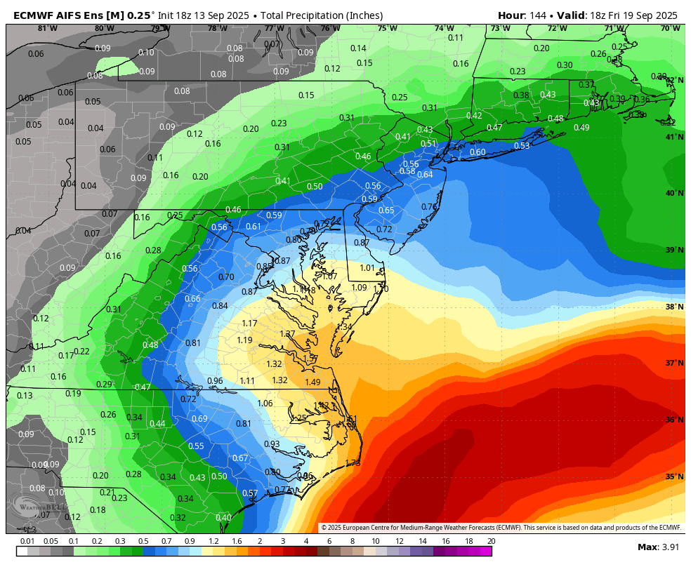
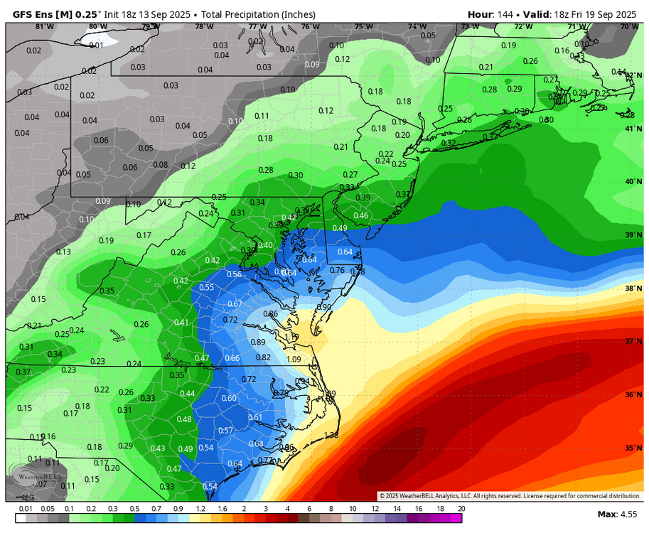
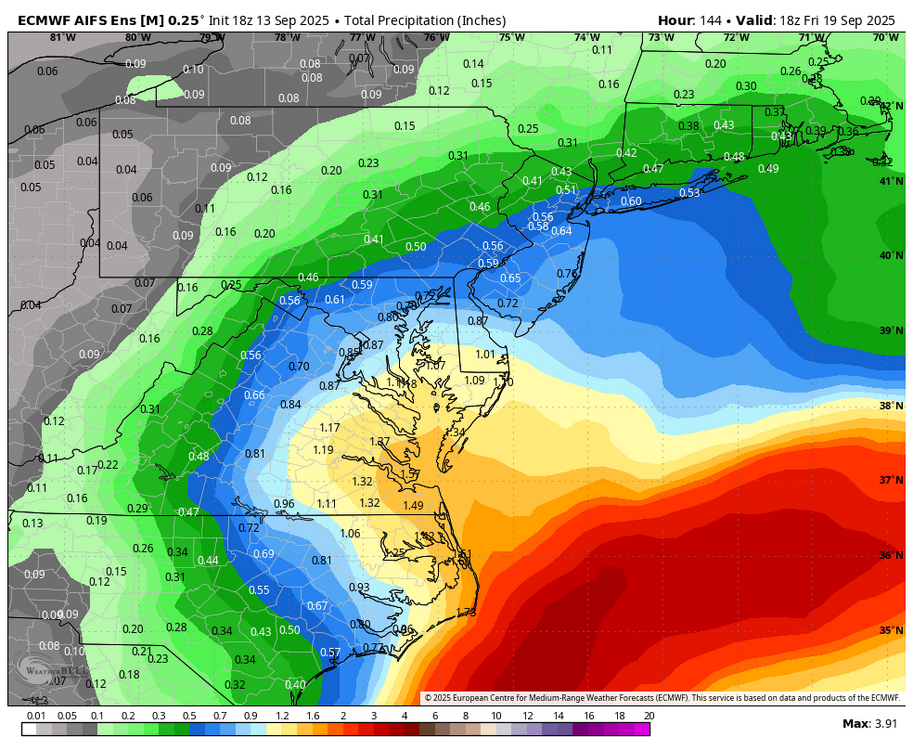
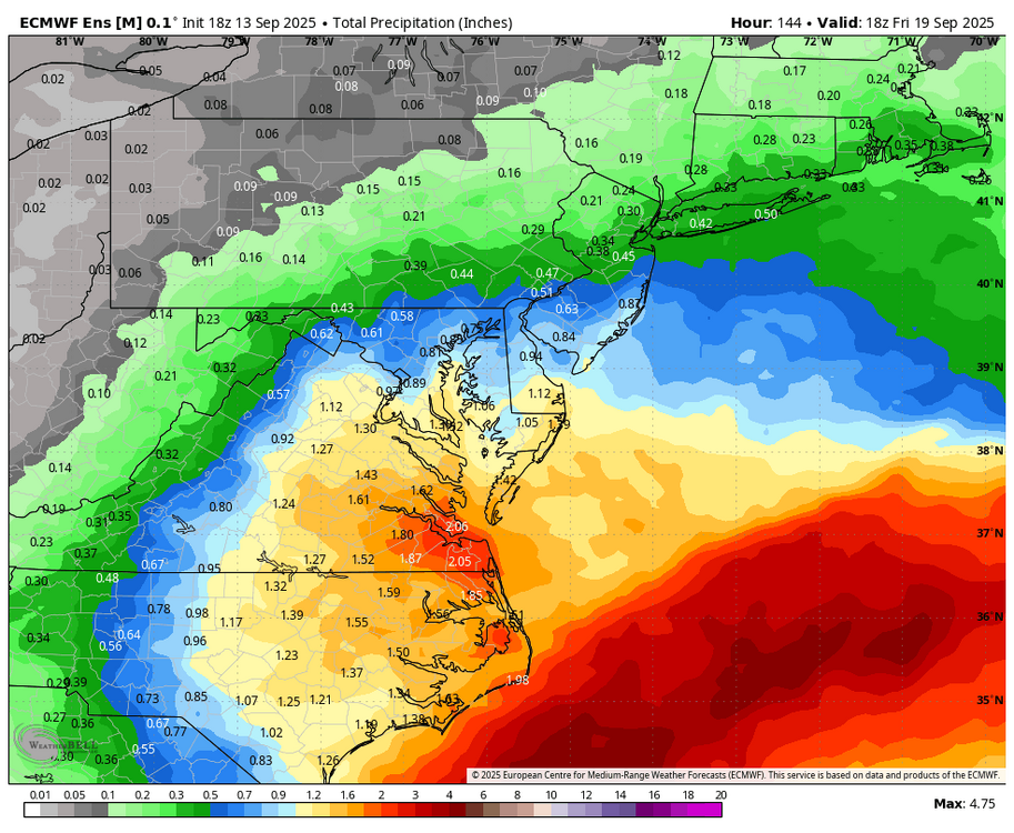
WB 18Z ensemble rain totals thru day 6. GFS, EURO AI, and Euro.
-
Made it to 97 at DVN today, 96 at MLI.
- Yesterday
-
another? they haven't even been bad here.. I was from the valley.. a shit winter here is a great winter there


.thumb.png.4150b06c63a21f61052e47a612bf1818.png)