CoastalWx Posted April 2, 2011 Share Posted April 2, 2011 Maybe a quick 1-2 inches for Nothern CT on north as we claw our way to 100 Yeah NAM would have some snow for you at the onset. We'll have to see how it looks as we close in, but it could easily go to crap. Link to comment Share on other sites More sharing options...
Typhoon Tip Posted April 2, 2011 Share Posted April 2, 2011 Just looking at the step-back synoptics ... I not so sure that warm front really is going to make it to MHT as fast as this 12z NAM depicts. It may get there, but retard the timing some. Even though there is a retreating high E of NE, I'd rather see that retreat SE at this time of year. The particulars about the isobaric curvature in the PP throughout the area shows there could be a problem with some ageostrophics putting up a good fight. Doesn't mean anything as far as snow goes... Looks like BL problems to me... Sunny on Sunday heats the ground... We radiate nicely and folks get excited for a kind of cheating 1-2", but then the clouds come in and so much stored radiation then warms the BL under cloud canopy. See that ofter enough in the spring. Link to comment Share on other sites More sharing options...
weathafella Posted April 2, 2011 Share Posted April 2, 2011 http://www.youtube.com/watch?v=LMc263klrMQ Link to comment Share on other sites More sharing options...
Typhoon Tip Posted April 2, 2011 Share Posted April 2, 2011 http://www.youtube.com/watch?v=LMc263klrMQ Haha- Someone should start a Mod-backed thread with a macro built into the back end, the title of which says, "Get with the program and accept it, and stop trying to ferret out snow!", and if any poster tries to refute this realism, said macro bands them, in such a way that every time they try to log in they are instead prompted with: "Nope, because you are a snow cook" Link to comment Share on other sites More sharing options...
Ginx snewx Posted April 2, 2011 Share Posted April 2, 2011 http://www.youtube.com/watch?v=LMc263klrMQ If you think about it he really looks like an aged Pete MRG Link to comment Share on other sites More sharing options...
dendrite Posted April 2, 2011 Share Posted April 2, 2011 lol...NAM pushes warning criteria for the higher elevations here. I wish this could come in overnight instead of during the entire daylight hours. Link to comment Share on other sites More sharing options...
dryslot Posted April 2, 2011 Share Posted April 2, 2011 lol...NAM pushes warning criteria for the higher elevations here. I wish this could come in overnight instead of during the entire daylight hours. Looks liquid here.. Link to comment Share on other sites More sharing options...
HoarfrostHubb Posted April 2, 2011 Share Posted April 2, 2011 It gon snow Link to comment Share on other sites More sharing options...
free_man Posted April 2, 2011 Share Posted April 2, 2011 let it go........................................ You're back on the Spring train? Hopefully we get a nice week or two of just baking, torrid torch to warm up those SSTs. Link to comment Share on other sites More sharing options...
CoastalWx Posted April 2, 2011 Share Posted April 2, 2011 Well for the most part it is over, but nothing wrong with a little disco. Link to comment Share on other sites More sharing options...
Typhoon Tip Posted April 2, 2011 Share Posted April 2, 2011 Well for the most part it is over, but nothing wrong with a little disco. Yeah, I'm just rubbing it in... Truth be told, "it's over" should n't matter at any time of the year - if it's on the charts, it's on the charts. Link to comment Share on other sites More sharing options...
OKpowdah Posted April 2, 2011 Share Posted April 2, 2011 I wonder how close we are to getting some Miller B action for eastern New England Wednesday morning Link to comment Share on other sites More sharing options...
HoarfrostHubb Posted April 2, 2011 Share Posted April 2, 2011 Yeah, I'm just rubbing it in... Truth be told, "it's over" should n't matter at any time of the year - if it's on the charts, it's on the charts. Supposedly it was ove rin early Feb, and that white stuff still on my lawn is a figment of my kooky imagination. Amazing how fast 8" of snow melts in April... almost all gone Link to comment Share on other sites More sharing options...
HoarfrostHubb Posted April 2, 2011 Share Posted April 2, 2011 I wonder how close we are to getting some Miller B action for eastern New England Wednesday morning Stop... it's ova What are you looking at? Link to comment Share on other sites More sharing options...
simpsonsbuff Posted April 2, 2011 Share Posted April 2, 2011 If KLEB actually gets more Snow sticking to real surfaces (not the coldest surface you can find) on Monday vs. this past Friday, I'd laugh pretty hard. Link to comment Share on other sites More sharing options...
OKpowdah Posted April 2, 2011 Share Posted April 2, 2011 Stop... it's ova What are you looking at? Energy rounding the base of the full latitude trough, triggering secondary development along the cold front, which may throw some precip back to the west into the cold sector. But more likely is the secondary low doesn't become very coherent and it all sweeps east. Link to comment Share on other sites More sharing options...
CoastalWx Posted April 2, 2011 Share Posted April 2, 2011 Energy rounding the base of the full latitude trough, triggering secondary development along the cold front, which may throw some precip back to the west into the cold sector. But more likely is the secondary low doesn't become very coherent and it all sweeps east. Euro is even more bullish now with a secondary wave. It argues a few to perhaps several inches over the interior, and even to the coast. Now we know these setups can fail, but the 12z run got interesting. It did take some away for Monday morning. Link to comment Share on other sites More sharing options...
OKpowdah Posted April 2, 2011 Share Posted April 2, 2011 Euro is even more bullish now with a secondary wave. It argues a few to perhaps several inches over the interior, and even to the coast. Now we know these setups can fail, but the 12z run got interesting. It did take some away for Monday morning. Yeah the Euro gets the most interesting. The CMC has been hinting at it the last few days, but it has a bit of a high amplitude / cutoff bias when it comes to these full latitude troughs Link to comment Share on other sites More sharing options...
Typhoon Tip Posted April 2, 2011 Share Posted April 2, 2011 Interestingly convective out there today... 53 to 40 here in Ayer in about 3 minutes of 45mph wind blast out of a bullet shower. There are some low-top anvils around some of the horizons, too. Nice! Get that April sun cooking underneath anomalous cool ml and gets fun fast. Link to comment Share on other sites More sharing options...
OKpowdah Posted April 2, 2011 Share Posted April 2, 2011 Nice influence of the Great Lakes Link to comment Share on other sites More sharing options...
Mr Torchey Posted April 2, 2011 Share Posted April 2, 2011 Spectacular day! 57 sunny all day, some puffs just now moving in from the nw, God I love spring. Its ovaaaaaaaaaaaaaaaaaaaaaaaaaa Link to comment Share on other sites More sharing options...
weatherMA Posted April 2, 2011 Share Posted April 2, 2011 Spectacular day! 57 sunny all day, some puffs just now moving in from the nw, God I love spring. Its ovaaaaaaaaaaaaaaaaaaaaaaaaaa 48 overcast breezy meh Link to comment Share on other sites More sharing options...
Mr Torchey Posted April 2, 2011 Share Posted April 2, 2011 48 overcast breezy meh Brutal, sucks, time for a bbq in the back yard sitting on the deck and making frozen margs!!!!!!!!!!! Link to comment Share on other sites More sharing options...
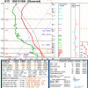
OKpowdah Posted April 2, 2011 Share Posted April 2, 2011 Pretty impressive 0-3km lapse rates Link to comment Share on other sites More sharing options...
CoastalWx Posted April 2, 2011 Share Posted April 2, 2011 Interestingly convective out there today... 53 to 40 here in Ayer in about 3 minutes of 45mph wind blast out of a bullet shower. There are some low-top anvils around some of the horizons, too. Nice! Get that April sun cooking underneath anomalous cool ml and gets fun fast. I noticed the same thing. Nice TCU. Link to comment Share on other sites More sharing options...
CT Rain Posted April 2, 2011 Share Posted April 2, 2011 Pretty impressive 0-3km lapse rates Spring in New England Link to comment Share on other sites More sharing options...
40/70 Benchmark Posted April 2, 2011 Share Posted April 2, 2011 I wonder how close we are to getting some Miller B action for eastern New England Wednesday morning Oh man, what I would give to have that come to fruition. Link to comment Share on other sites More sharing options...
CT Rain Posted April 2, 2011 Share Posted April 2, 2011 Oh man, what I would give to have that come to fruition. Euro comes close Link to comment Share on other sites More sharing options...
CoastalWx Posted April 2, 2011 Share Posted April 2, 2011 So the euro verbatim would imply, a mix at the onset for some on Monday morning. Muggy and near 60F Monday Night, followed by a possible flip to snow during Tuesday Night. Link to comment Share on other sites More sharing options...
40/70 Benchmark Posted April 2, 2011 Share Posted April 2, 2011 Euro comes close Would not suprise me if we pulled off a 1996 type April. Link to comment Share on other sites More sharing options...

Recommended Posts
Archived
This topic is now archived and is closed to further replies.