Arnold214 Posted April 2, 2011 Share Posted April 2, 2011 Thought I would start a new thread since our Tulip trouncer is over. Some of the guidance has been advertising a decent system to come rolling thru here starting monday. Some front end snow (maybe 1-2") for some Monday morning? I was also noticing that the convective parameters are pretty impressive for Monday night on the new NAM...showing showalters down to between -2 and -5C with K indices 33-38C across a good chunk of New England (30c is a general rough cutoff for isolated thunder). I think the wx could be quite changeable between monday and wednesday...with a low prob of some light anafrontal snows behind the front...although it seems like a long shot at this point. Any thoughts? Link to comment Share on other sites More sharing options...
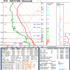
Arnold214 Posted April 2, 2011 Author Share Posted April 2, 2011 Here's the latest NAM precip/snowgrowth profile for ORH centered around Monday. The other models are pretty similar. 20 microbars in the SGZ Monday morning with an isothermal profile around 0c. Mini sw flow event in advance of the warm front that could deliver an inch or two if the timing is right. Link to comment Share on other sites More sharing options...
40/70 Benchmark Posted April 2, 2011 Share Posted April 2, 2011 Ek, any shot of the lower elevations getting measureable out of that Monday deal....funny, I gave the EURO one last gander before going through w the suspension of my SV package and stopped to ponder Monday, but thought......"nah"...moth ball time. Link to comment Share on other sites More sharing options...
Arnold214 Posted April 2, 2011 Author Share Posted April 2, 2011 Ek, any shot of the lower elevations getting measureable out of that Monday deal....funny, I gave the EURO one last gander before going through w the suspension of my SV package, but thought......"nah"...moth ball time. The nam forecast soundings for Wilmington/Billerica have you snowing monday morning (even at 18z it's an isothermal snow there). It's actually pretty cold 12z monday morning at 850 over NE MASS...anywhere between -3C to -6C. Obviously, best shot at accumulating snow would be if the precip came in as early as possible monday morning. Nam could be too cold in the boundary layer but we'll see. The SREF probs for ptype have you right in a very tight gradient between rain and snow probs. Link to comment Share on other sites More sharing options...
40/70 Benchmark Posted April 2, 2011 Share Posted April 2, 2011 The nam forecast soundings for Wilmington/Billerica have you snowing monday morning (even at 18z it's an isothermal snow there). It's actually pretty cold 12z monday morning at 850 over NE MASS...anywhere between -3C to -6C. Obviously, best shot at accumulating snow would be if the precip came in as early as possible monday morning. Nam could be too cold in the boundary layer but we'll see. The SREF probs for ptype have you right in a very tight gradient between rain and snow probs. Thank you....I'll hold off until Monday before implementing the suspension.....need 3.3" to catch 1977 and 1993..very long shot, but I'll take an inch or so becuase you never know when I may run into an inch or two later in the month, or even May. Link to comment Share on other sites More sharing options...
40/70 Benchmark Posted April 2, 2011 Share Posted April 2, 2011 If by chance the NAM isn't too cold (yea, yea ), I like our chances of getting it in a little ahead of guidance; you know the drill w respect to SWFEs. Link to comment Share on other sites More sharing options...
nzucker Posted April 2, 2011 Share Posted April 2, 2011 If by chance the NAM isn't too cold (yea, yea ), I like our chances of getting it in a little ahead of guidance; you know the drill w respect to SWFEs. What are you guys thinking about the cold snap behind this system? Looks pretty severe, no? I'm hoping that the second wave the GFS shows can attempt to ride the coast and give us some light snowfall.... Link to comment Share on other sites More sharing options...
Arnold214 Posted April 2, 2011 Author Share Posted April 2, 2011 Thank you....I'll hold off until Monday before implementing the suspension.....need 3.3" to catch 1977 and 1993..very long shot, but I'll take an inch or so becuase you never know when I may run into an inch or two later in the month, or even May. If the 12z EC holds serve you actually have a shot at 1-3" Wed night/Thu morning. Link to comment Share on other sites More sharing options...
40/70 Benchmark Posted April 2, 2011 Share Posted April 2, 2011 If the 12z EC holds serve you actually have a shot at 1-3" Wed night/Thu morning. Oh man....I'm cautiously pumped....suspension cancel, for now... Link to comment Share on other sites More sharing options...
40/70 Benchmark Posted April 2, 2011 Share Posted April 2, 2011 Have to ask....how does Kev look in this... Link to comment Share on other sites More sharing options...
40/70 Benchmark Posted April 2, 2011 Share Posted April 2, 2011 What are you guys thinking about the cold snap behind this system? Looks pretty severe, no? I'm hoping that the second wave the GFS shows can attempt to ride the coast and give us some light snowfall.... Haven't looked. Link to comment Share on other sites More sharing options...
Arnold214 Posted April 2, 2011 Author Share Posted April 2, 2011 Have to ask....how does Kev look in this... 6-12" with lolli's of 18. Actually, for monday he could be better off in a way b/c the precip would get to him a few hours before it gets to you...but on the other hand the antecedent airmass is a bit colder up your way. Might be a wash. If the EC holds serve, then you would be in much better shape than him thurs morning. Anyway, it's not much but the threat for some accumulating snowfall is still there for at least the next week. Link to comment Share on other sites More sharing options...
40/70 Benchmark Posted April 2, 2011 Share Posted April 2, 2011 6-12" with lolli's of 18. Actually, for monday he could be better off in a way b/c the precip would get to him a few hours before it gets to you...but on the other hand the antecedent airmass is a bit colder up your way. If the EC holds serve, then you would be in much better shape than him thurs morning. Anyway, it's not much but the threat for some accumulating snowfall is still there for at least the next week. I could still conceivably catch him. This race is awesome...best btwn us of any season, yet....right down to the buzzer. Link to comment Share on other sites More sharing options...
Arnold214 Posted April 2, 2011 Author Share Posted April 2, 2011 I could still conceivably catch him. This race is awesome...best btwn us of any season, yet....right down to the buzzer. He already rented a post hole digger for his yard...for a place to stick his ruler. Link to comment Share on other sites More sharing options...
40/70 Benchmark Posted April 2, 2011 Share Posted April 2, 2011 He already rented a post hole digger for his yard...for a place to stick his ruler. It would kill him if I caught him....we were texting today and I asked what he got....he was appaprently so nervous that he made me tell him first. He was like "I was worried when I saw radar this morning. Phew." Link to comment Share on other sites More sharing options...
ORH_wxman Posted April 2, 2011 Share Posted April 2, 2011 Since the other thread was locked....here are some pics from really early this morning right after "sunrise" Near peak intensity...at least after it was light out: Sticking to the roads pretty good...though lower down it had a much harder time Little drift on the roof Guy out walking his dog early took a pic of me as I was driving over to the clearing to get measurements Link to comment Share on other sites More sharing options...
Arnold214 Posted April 2, 2011 Author Share Posted April 2, 2011 Since the other thread was locked....here are some pics from really early this morning right after "sunrise" you can go ahead and unlock and post the pics in there if you want...I just figured with it nearing 2000 posts it was time to can it. No biggie. Link to comment Share on other sites More sharing options...
ORH_wxman Posted April 2, 2011 Share Posted April 2, 2011 you can go ahead and unlock and post the pics in there if you want...I just figured with it nearing 2000 posts it was time to can it. No biggie. Eh, its cool. I'll post them in the photography forum too. One thing that I noticed compared to when a took a couple pics at night....the snow definitely got a bit drier toward morning. You can see it had a slightly drier appearance. How much did you guys end up with there? This left me at 98.3" for the season. Maybe I can pull out a garbage 2" somewhere before its totally over to get past 100". Link to comment Share on other sites More sharing options...
weatherwiz Posted April 2, 2011 Share Posted April 2, 2011 Ekster mentioned thunder possible Link to comment Share on other sites More sharing options...
Arnold214 Posted April 2, 2011 Author Share Posted April 2, 2011 Eh, its cool. I'll post them in the photography forum too. One thing that I noticed compared to when a took a couple pics at night....the snow definitely got a bit drier toward morning. You can see it had a slightly drier appearance. How much did you guys end up with there? This left me at 98.3" for the season. Maybe I can pull out a garbage 2" somewhere before its totally over to get past 100". You'll get your garbage 2" within the next 10 days somehow. Hopefully we'll be tracking some highly anomalous spruce shredder on Apr 20th or something like that. Anyway, I ended up getting 9.2" at my place. It was like 8:1 stuff. We ended up with 10.4" at the office with a water equiv of 1.20. On a side note, it was nice to actually be able to enjoy a nice early april crocus crusher. If I still lived in Attleboro, a lightning bath would have been had. Link to comment Share on other sites More sharing options...
Damage In Tolland Posted April 2, 2011 Share Posted April 2, 2011 Have to ask....how does Kev look in this... LOL..you are looking for any way to catch me. Catch me if you can little fella Link to comment Share on other sites More sharing options...
cpickett79 Posted April 2, 2011 Share Posted April 2, 2011 weenie flake mon am? i guess i'll take the half inch i'm at about 90 for season after yesterdays solid 5 or so Link to comment Share on other sites More sharing options...
Mr Torchey Posted April 2, 2011 Share Posted April 2, 2011 let it go........................................ Link to comment Share on other sites More sharing options...
HoarfrostHubb Posted April 2, 2011 Share Posted April 2, 2011 Eh, its cool. I'll post them in the photography forum too. One thing that I noticed compared to when a took a couple pics at night....the snow definitely got a bit drier toward morning. You can see it had a slightly drier appearance. How much did you guys end up with there? This left me at 98.3" for the season. Maybe I can pull out a garbage 2" somewhere before its totally over to get past 100". You've been 10" ahead of me forever. I thought I could catch you but oh well. Link to comment Share on other sites More sharing options...
ski MRG Posted April 2, 2011 Share Posted April 2, 2011 I could still conceivably catch him. This race is awesome...best btwn us of any season, yet....right down to the buzzer. I was ambivalent about your race until I saw Kev's taunting post. Go Ray! Link to comment Share on other sites More sharing options...
CoastalWx Posted April 2, 2011 Share Posted April 2, 2011 NAM and Euro seem to be the coldest of the models and do offer a chance of snow in the morning on Monday. Here's the NAM on Monday morning. Note the yellow like which is the 850-700 critical thickness line is near BOS and ne mass. The euro offers a brief period of snow as well. I don't have access to the good stuff at home, but I can see 925mb temps wetbulb down to below 30F during Monday morning. It also offers the chance for a brief flip to aggregates at the end as Mike mentioned. Best shot of front end snow would probably be nrn mass near the NH border, but NAM argues for Logan to have some glop possibly. Link to comment Share on other sites More sharing options...
Typhoon Tip Posted April 2, 2011 Share Posted April 2, 2011 Here's the latest NAM precip/snowgrowth profile for ORH centered around Monday. The other models are pretty similar. 20 microbars in the SGZ Monday morning with an isothermal profile around 0c. Mini sw flow event in advance of the warm front that could deliver an inch or two if the timing is right. Somewhat reminiscent of that system in February that started the day off with some snow, and then that night we had fast moving clusters of thunderstorms... Different synoptics leading, however. Sort of indirectly related ... both the primary indexes that signal our weather, the PNA and NAO, are correlating to a warm pattern for eastern N/A (this is true at both CDC and CPC). This may not be consistent with OLR distribution from the tropical Pacific and forcing down stream, but it is what it is. Heh, this entire last year has verified patterns antithetic more so than not relative to the ENSO, so go figure ... That said, having a -1 to -1.5SD PNA forecast to persist for 2 straight weeks, at some point the back of the deterministic cool appeals might just break and reel to the onset of some kind of SE ridge. That, as a start, would be useful for those whose interest in weather are more in this side of the aisle. Not that anyone asked but for me it is seasonally guiding.... In October, my heart starts beating to the tempo of repeating snows; in the spring, the last thing I want to see on my middle range charts is situations like that bull crap yesterday. But I digress... In fact, we are seeing some hints of the capitulation to warmer pattern already. The NCEP D6-D10 temperature anomaly distribution is flagging a warmer than normal SE 1/3 of the conus. Meanwhile, the operational ECM has a pretty big plume of warm sector that is invaded as far north as the U.P. of Michigan! This air gets in here, however brief on the model, but only gets knocked down by an "iffy" looking N stream around D9 (I bet it backs off on that...). One thing also, at least through July 1 we don't want south, or even south by southwest wind trajectories in the BL for obvious reasons. Regardless of how ominous any given deep layer synoptic appeal may be, if we get that wind trajectory, anyone east of say a ...CEF ---EEN line is left to enjoy only the party's debris. I have seen walls of 50-65dbz roar through Berkshire County, and then arrive in Acton, Mass as 30dbz light rain because of this indirect poison from off the cold shelf waters S of LI, and the Sound its self. And ... this is high sensitive impact too. Interestingly, I have seen this virtual wall of thunderstorm venom operate on dismantling updrafts when the temperature and DP are barely registering the S wind's influence. Like ...in mid summer, say 90/72 in ALB with severe in the area, and a watch has been issue clear to I-95, where places like BED are 88/ 66, yet squall lines split, and isolated storms dwindle. Meanwhile, the frustrating part is that the SBCAPE products don't often really reflect a loss of instability. Anyway, the point being is that at this time of year, we DEFINITELY don't want that wind. It can be overcome though... One way is to have extreme vertical temperature instability... Another way is to have the action be based more on MLCAPE. I recall once 38F with frequent lighting and small hail, in calm wind up at UML from elevated convection. In any event, most the major operational guidance types agree on a more fluctuate pattern between warm and cool sectors. That combined with some semblance of SE ridge return is at least a good probability foundation for thunder intervals. Link to comment Share on other sites More sharing options...
CoastalWx Posted April 2, 2011 Share Posted April 2, 2011 New NAM has a nice burst between 12z and 15z or so. It actually has 2M temps cooling from 12z through 18z. It's really interesting for the nrn portions of the state. Link to comment Share on other sites More sharing options...
mahk_webstah Posted April 2, 2011 Share Posted April 2, 2011 I was ambivalent about your race until I saw Kev's taunting post. Go Ray! It is a preview of the Yankees Sox race this year. So you know Ray will win both times. Link to comment Share on other sites More sharing options...
Damage In Tolland Posted April 2, 2011 Share Posted April 2, 2011 Maybe a quick 1-2 inches for Nothern CT on north as we claw our way to 100 Then elevated thunder Monday night..Could be a nice light show Link to comment Share on other sites More sharing options...

Recommended Posts
Archived
This topic is now archived and is closed to further replies.