Search the Community
Showing results for tags 'snow'.
-
 This posts due to forum interest in wintry weather, but with uncertainty on evolution of precipitation events and how far south ice or snow can develop (even a low chance NYC). Marginal thermal profiles may limit snow or ice to I84 northward but may be worth monitoring for a minor or moderate wintry weather event I84. The NAEFS pattern along with various models, though cyclically inconsistent, suggest the possibility that the latter part of the Mondays(14th) precipitation could be a little ice or even end as snow along the I84 corridor. A wintry event possibility. Evolution thereafter is uncertain but it appears there will be some sort of decent storm system heading into the northeast USA which has a chance to involve snow-ice, at least along the I84 corridor. It's possible short wave interactions will force a northward buckle of the thicknesses and result in all rain but for now, I think there is enough model guidance to open the door for some wintry weather, mainly I84, sometime between 16th-18th. Confidence for one or two precipitation events in that 5 day period is above average, and a good sign is the constancy of a decently strong upper level jet just to our south (LF quad= exit region), frequently with the jet core near VA. Normal High Low at CP next week is ~43-32. Added two graphics: the WPC midday Tuesday (8th) chance of of more than 1/4" frozen water equivalent Monday the 14th. and the CPC D6-10 outlook for the 14th-18th. As we draw closer, it may be that we'll delete some of this and refocus the topic title- for now, this should hold us. Let's see if we can get a little winter in our area next week.
 -
This topic for Friday-Sunday dual event is posted with much lower issuing confidence than the topics of 11/11-15, and 11/30-12/01. There may be several verifiable flood (not flash flood) warnings for rivers-small stream in northern NJ-northwest of I95 by Sunday morning from a widespread 1-2" rainfall, isolated 3" possible. There is a small chance for 45+ MPH gusts. It appears the best chance of verifiable hazards will be along the I84 higher terrain where ice or snow can occur. The ice or snow amounts 3-4 days in the future cannot be counted on to be more than 1 tenth inch glaze or more than 3" of snow, though the option exists for heavier snowfall north of I84. Lead precipitation Friday afternoon and night is associated with a reinforcing cold front. Rain NYC. However the I84 corridor may see some wet snow Friday night? mPING. Saturday: Chilly rain most of the NYC forum, heavy at times with 1-2" general, isolated 3". I84-best chance that there could be some ice Saturday before cooling thicknesses and the rapidly developing low change precipitation to some snow before it ends Saturday night or Sunday morning. mPING may be quite helpful. Winds: Depends how fast the storm develops. If a 998MB low is south of Islip Saturday-then brief northeasterly gusts 40-50 MPH Saturday would be possible on LI and the NJ coast, otherwise I think there may be a better chance of northwest wind gusts 45-50 MPH Saturday night or Sunday morning as the storm moves rapidly past Boston. After further review, I don't think tidal flooding will be a significant threat Saturday. Starter graphics: 6 hr FFG..shows the vulnerable areas. Once yesterdays wave off rising river waters passes Wednesday night, I'll add some small stream guidance-if it applies. Added the 12z/1 GEFS prob of 1". Yellow is up around 75-80% chance. The 12z/1 EPS also has 1-1.5" as does the 12z/1 NAEFS. Final starter graphic is a 52 member NAEFS blend of where the sfc low will be and it's intensity Saturday evening. You'll note the yellow color northeast of the center... that implies greater variability of the pressures there..and could mean that the surface low will be further northeast by Saturday evening. Good luck with this... I hope this topic will produce some verifiable NWS hazards. 521P/1
- 373 replies
-
- 6
-

-
- heavy rain
- wind event
- (and 2 more)
-
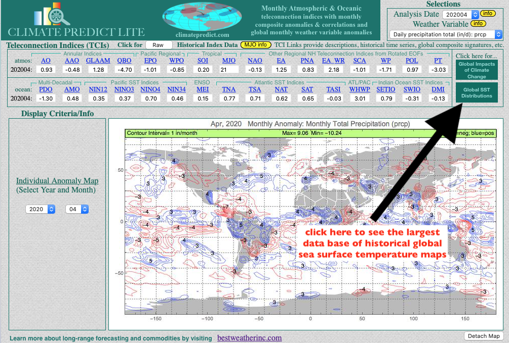
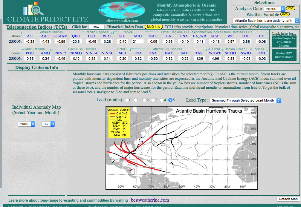
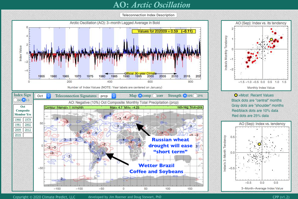
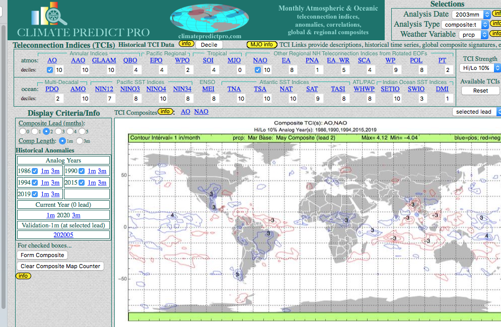
 As a lover of the weather, many of you are probably interested and potentially talented enough to learn how to use your skill to trade commodity futures and conservative options such as natural gas (UNG), coffee (JO) and the grain market. While everyone gets excited about snowstorms, there is just as much potential excitement watching stocks and commodities affected by weather. Yes, watching stocks such as Apple and Amazon soar over the years may. not be your cup of tea, so why not learn how to use weather forecasts to make investments in things affected by weather. While I am firm believer in climate change and a warming planet, this winter has the potential to be much colder. I began telling clients last week that I thought we would go into a negative Arctic Oscillation Phase as shown on the upper right. Other than La Nina, it is quite possible that "aerosols" from the historic western fires are getting caught up in the atmosphere and warming the Arctic. This will help the AO index to go negative with cold late fall weather in at least the Midwest and possibly the eastern U.S. OCTOBER GLOBAL RAINFALL ANAMOLIES WHEN THE AO INDEX IS NEGATIVE My teleconnection program at www.climatepredict.com is free for you to use and you can click on different teleconnections such as the AO index and see historical rainfall, snowfall and temperature trends months in advance. Notice, for example, how in October other commodities such as coffee, wheat and soybeans are influenced by the negative AO index. I will be starting a much less expensive, monthly global commodity weather newsletter that is much more affordable from my web site www.bestweatherinc.com. and if you are interested in learning about commodities and weather you can always sign up for a FREE trial Regards, Jim
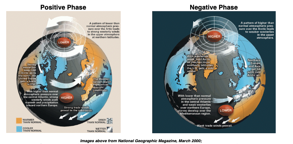
-
Not much to really say here. This winter was an abysmal wet mess, best to be forgotten. The grades (all items are equally weighted) Overall Seasonal Snowfall: F Well under average snow fell. This may have been my worst snowfall ever in any of the places I have lived (Albany, NY area, Lake George area, Bristol, R.I., Washington DC, Arlington, VA, Boston, Ma, Stoughton, MA, Brooklyn, CT) . I don't think I have ever had a winter season where the snow total was less than half of the average. Even the 2011/2012 had more snow. Snow vs. Rain: D+ Such an ongoing sh.itty set up for my area from January onward, and it seemed to just repeat itself all season. Cold rain was king. Staying power of the pack: F Pack? Local winter enjoyment: D- Limited hikes(w/ snow) hikes or snow, and zero snow shoeing hikes. Temperature: D Snow Storm Quality: C- Only one "memorable" event was the first event of the season, December 1-3. There were ZERO double digit events. Overall Grade: F The Vid took my mind off of the later part of the season, but even a late blooming April event couldn't save what was a complete and utter dead rat of a winter. On to the upcoming 2020/2021, Winter of Mask
-
I have had a bunch of requests to make available historical global ocean temperatures so you can compare various El Nino, La Nina events and much more to any year of your choice. Now you can access everything you need for FREE here CLIMATE PREDICT including all hurricane tracks, snow cover maps and much more back to 1958

-

Winter of 2019-20 IN PICTURES - Southeast Michigan
michsnowfreak posted a topic in Lakes/Ohio Valley
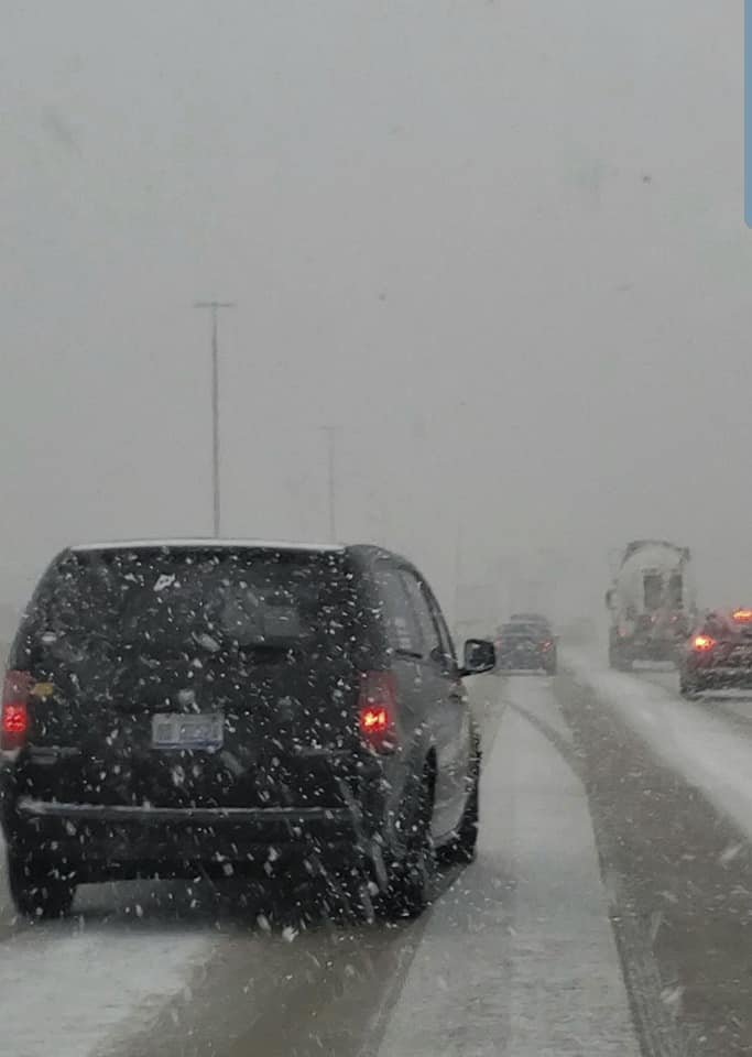
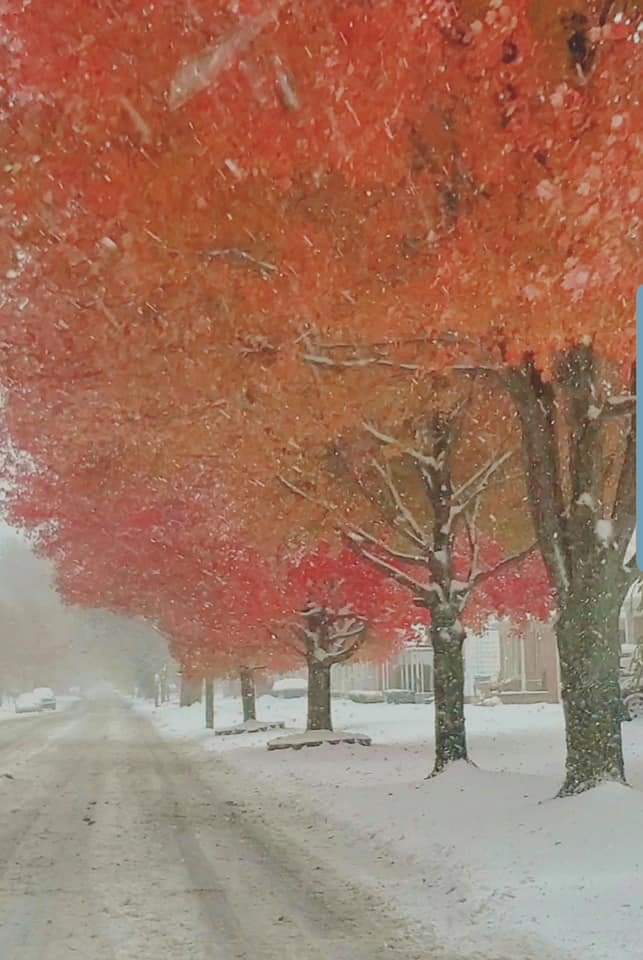
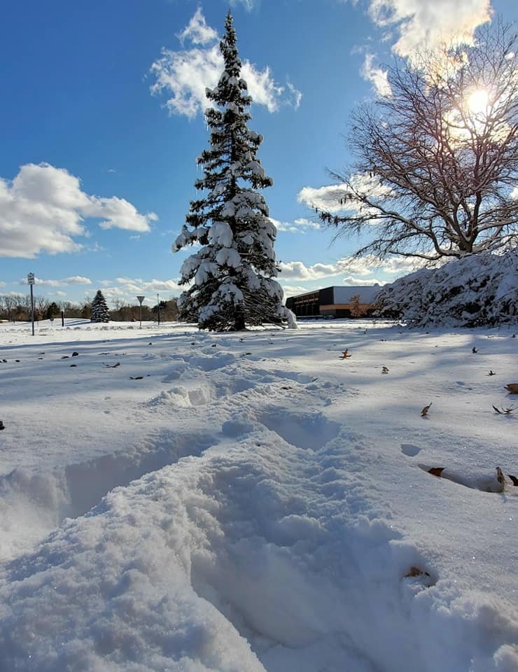
Ive been doing this 2003 on weather boards. In the boards hey day it was quite a popular post lol. I still like to do one every year. Winter 2019-20 saw 43.8" of snow imby. DTW had 43.7". After Detroit saw the largest November snowstorm on record, the earliest single digit temp on record, and the 13th coldest November on record, we followed with the 9th warmest winter on record, and then frequent snow and near record cold in mid-late April and again, of all things, in early-mid May. Overall a winter of frustration but not without several good snowstorms and in the end, average snowfall. Three decent storms hit (8.8", 7.0", and 5.7") and much of the seasons snow had a high water content, with the only true period of fluffy snow being in early Feb. October 2019 - Trace of snow Wind-driven rain turned to snow Halloween night, with no accumulation. November 2019 - 9.1" of snow The first half of Nov was the 2nd coldest on record, behind only 1880, and saw a 9.2" snowstorm on Nov 11-12 become the largest Nov snowstorm on record for Detroit (old record 9.0"). I saw 8.8" with that storm. The scenes were surreal with some trees clinging to late color. A record low of 7F on the 13th was the earliest single digit low on record, and a solid blanket of snow remained on the ground for 9 days, fully melting on the 12th day. 11-7-19 heavy snow squalls drop 0.2", the first measurable snow of the season 11-11-19 heavy snow drops an unprecedented amount of snow for so early in the season 11-12-19 - beautiful scenes and record cold follow snowstorm which dumped 8.8" of snow imby and 9.2" at Detroit, 11-14-19 a light dusting of snow falls but the deep winter wonderland is still in place with record mid-Nov cold 11-16-19 still plenty of snow in place for the Wyandotte Christmas parade. The ground would go bare Nov 21.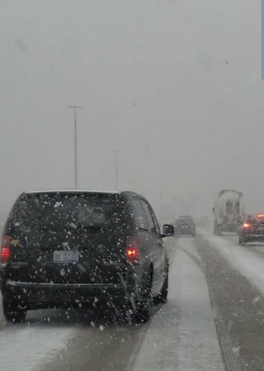


-
Hi there, I have been a meteorologist and commodity analyst for 35 years. I am really excited about offering meteorologists FREE access to my software and how you use teleconnections to forecast better. There is a site on the internet at NOAA that allows forecasters to do analog studies, etc. but here is a great product that allows you to receive 1) Historical snowfall and hurricane maps going back 70 years; 2) Looking at the relationship of any of 28 global teleconnections (From the MJO to the AO/NAO index and many more) to predict rainfall, temps, etc. months in advance. You can check this out and get all sorts of historical data at CLIMATE PREDICT Whether your want to know how the Indian Dipole might change and affect crops in Southeast Asia, or which analogs will best help you forecast summer weather for natural gas regions, severe weather or hurricanes, check it out. I would be happy to answer any questions you may have about teleconnections. Regards, Jim Roemer www.bestweatherinc.com

-
Almost everything outside of the mid-week light snow shower chance is now based in hoping February's decent ensemble modeling trends aren't the 40th head fake of the winter season. The GEFS snow mean is nice but seemingly meaningless the past few winters, as it has virtually not verified in 48 months when it shows these snowy solutions. The Euro at D10 looks better than it did at day 10 yesterday, so there's that. Still looks like a robust frontal passage behind a cutter in a fast moving pattern, rather than something that will set up shop and allow for truly cold weather to arrive for any length of time. If we get lucky and the Polar Vortex splits but will it help us? It split last year and record breaking cold hit the Midwest but didn't propagate into our back yards. I've not looked but I'd guess there's been very few times when Chicago had highs in the -10 range that it didn't get cold here. Last year that happened and we stayed warm. It also takes a few weeks for the PV to change weather in the Lower 48 most of the time. That would put us on track for the backside of February into March at best, where even with the aid of the TPV we'd probably be looking at lower elevation cold rain and elevated snow unless we got a bowling ball. If we are still hoping to reel in something in the D9-16 range in a week or 10 days, winter is likely over until late March or April, where it will invariably turn frigid for 2 weeks with rain or snow showers.
-
A series of clippers looks likely, they are notoriously fickle in the area. Earlier the Saturday clipper was showing up for West Tennessee but now looks like it's shifted east. As always the higher up the better. I wouldn't be shocked to see the Smokies end up with over a foot when it's all said and done. The Plateau could get a few inches as well. Crossville to my area seems to be in the 1-3 inch range through Saturday. As always it will depend on timing and surface temps. Night would be much better.
-
Going to get this loaded and on-deck for observations for December, January, and February. Specific events will likely have their own observation threads. This thread is for the time in between events. Winter is coming! In honor of the last Skywalker movie...
-
Figured we could have a separate thread dedicated strictly to December. Should be helpful when looking back on the discussions in the future. Hope everyone is doing well, and I hope we all have a December to remember!
-
Good Monday morning (Jan 20) everyone, Am a little uneasy starting this event specific topic since uncertainty exists regarding thermal profile and latitude of the primary-secondary development but I thought it best to get this going since it's a potential national news story from the Ohio Valley-Great Lakes to the interior northeast. Upfront: NYC-LI doesn't look promising at this time for more than 3" of snow , if any snow at all, due to the marginal thermal profile in advance of this system. The GEFS through 00z/20 was north of the EPS. There is still plenty of time-room for adjustment but at face value (00z/20 ensembles), this looks to me to be a primarily a northeast PA, northwest NJ northeastward into nw CT (I84 corridor) wet snowstorm with lots of potential (for a bust=no significant snow). My take is it will snow there for a time and that this event could be substantial impact upon higher terrain. I'm adding some graphics - these should not amp up NYC or points south.... but for me serve as a starter for a winter event. These include the 05z/20 NWS ensemble chance of 3+ inches of snow which is less than 10% for NYC. Then I've added..courtesy of the ECMWF and Weather.US, the 00z/20 EPS probs for 3 and 6" for this event (6 days in advance). I've also added the 00z/20 GEFS snowfall plume for LGA which is very low... most plumes under 2". This all adjusts as we move forward in time. If you want to root for snow, root development south of both ensemble systems 00z/20 positions. Am still concerned this will end up north and warmer (rain) up to I84. 625A/20
-
Good Monday morning everyone, Have offered to focus the general discussion thread on next weekends storm into one single thread. It's been a terrible winter so far s of I80 and not much to boast about north of I80. I'm adding graphics daily at about this time, until the threat fails to materialize. No guarantees on anything. It does not look good for NYC south, so far. Contributions are from the NWS public domain and the Weather.US and the ECMWF. We'll see how this verifies for long range value. The first two graphics are the NWS ensemble chance of greater than .25" water equivalent of frozen precipitation. These are run off of late day ensembles and post, "prior" to the 00z cycle ensembles. The two graphics courtesy of the ECMWF are the chances of 3+" of snow for this event which are increasing a bit in the I84 area and are from the 00z ensembles. No LOCK on any of this coming to pass though I'm pretty confident the interior west and north of NYC will have some sort of winter hazards this weekend. Depends I think, in part on how strong the northern stream short wave is that crosses the Great Lakes. The stronger it is, then I think the storm tracks further north. At 633AM the 14th, I added the 00z/14 NWS ensemble and EPS chance of 3+ inches of snow so that it's easy to go back and compare to reality. The risk has increased a bit for the NWS ensemble system to something similar to the EPS. Certainly no lock for 3+ inches s of I-84. At 457PM/19 added the NOHRSC snowfall analysis. Gives a feel for value in the ensembles. Later, Walt
-
Scattered snow squalls are likely to make it to near NYC midday Wednesday as a wind shift with steep lapse rates drives squalls out of NY state into the NYC metro area. Might have a few sprinkles at the beginning of any NYC squalls. Cant tell if it will be as dramatic as that of (Dec 18?). Probably not, but potential exists for rapidly changing road conditions in a couple of minutes in brief heavy squalls, especially northwest of NYC. Drier surface stabilizing cold air advection develops behind the squalls late in the day.
-
Hi everyone, While much of this very very minor snowfall within NYC metro should melt on pavement, it looks as though there should be a slightest coating on cars/grass. Areas to the west-north-northeast of the city should accumulate a little better with the 1/2" or possible isolated near 1" accumulations in the higher terrain. This event should do a little better than that of this past Saturday night-early Sunday (1/4-5) which saw scattered dustings of snow and snow pellets in the northwest hills of NJ into ne PA. The best we can do right now. Walt
-
Hi, This thread is for obs only, keeping it a swift read-check for anyone wanting to see how much has fallen, including any NWS/Media. Also, attached is a final NOHRSC snowfall analysis for our Dec 11 event, which now properly reflects the NYC reality of sub 1 inch. Thank you very much to all who have added data to the prior obs threads. Walt
-
Obs only thread basis: Model consensus (12z/10 NAM and HRRR now back northwest again) suggesting widespread accumulating snowfall of 1 to possibly 5" for the area, max axis unknown and most of it occurring within 4 hours of sunrise Wednesday as temperatures fall to within 2 or 3 degrees of 30 during the snowfall.
-
We now stand around 48 hours from snow falling in the area according to models. Anafrontal moisture will linger and allow the colder air to catch up, but how much cold and how much moisture remains the eternal question in our region. According to most model suites, plenty of both, but even though we are 48 hours out, models have been particularly bad at sniffing out actual snow events the last two or three years. So even with multiple model consensus that accumulating snow will happen, at best we can say "who knows?" at this point regarding how much, if any accumulates. Right now, Southern Arkansas to SEKY/SWVA look to be in play and the NAM is just namming it's heart out, having just delivered another juicy run for the region, especially mid and western areas of the Valley. WFO in the area remain rightfully skeptical, but are beginning to mention post frontal snow being possible, though in far less amounts than models are willing to churn out. Will it come to pass or go poof? Only the next 48-72 hours will tell. Still, our third potential event and it's not even solar winter yet, so things seem to be off to a good start.
- 486 replies
-
- 3
-

-
- snow
- rain to snow
- (and 2 more)
-
Hi! Would like to see an obs only page for this storm to make it easier to find the data, not only for myself but potentially the media with avid winter weather interest quite high. I'll add only 1 EXPERIMENTAL graphic from about 5AM this morning (Saturday 30th before the storm), but may eventually add pix to support observations as this complex event evolves in its banded - varying intensity form. The graphic below i think is realistic about axis of trouble and I can explain it a bit on the Dec 1-3 discussion page if requested, for those who've not seen this experimental product. Other NWS staff may improve on my interpretation. The legend should assist.
-
With significant post-frontal snow looking increasingly possible for the northern and mid tiers of the Tennessee Valley under current modeling, going forward I figured I'd start ourselves a little thread dedicated to it and the potential early start to the winter season!
-
This is a GREAT place for those not comfortable yet(on the pattern discussion forum) to place their observations. We really need some more folks from the western areas of our sub-forum to place observations here. We actually use those more than you know. Today has been HOT in the Tri-Cities with the third straight record high falling as we speak. Heat index is 96 out there. Feels like a horribly hot summer day. Just brutal. Another year and another hot Fall...I really don't like those. We do have some great discussion in the Fall Pattern Discussion and ENSO threads about when this heat may FINALLY break. Cause really for folks that cool weather, this sucks. LOL.
- 179 replies
-
- 3
-
-
-
- record heat
- transition
- (and 4 more)
-
Good morning American Weather participants, It might be nice to consolidate wintry precip reports for whatever this minor event delivers today, under one topic. While flurries have occurred in parts of the metro area (nw NJ for sure) on the 8th, today's short period of flurries or snow should be a little more widespread though confidence on where anyone sees a slight accumulation (especially grass-cars-rooftops) is less than ideal.
-

January 17th and 18th coastal storm final snow maps
USCAPEWEATHERAF posted a blog entry in Once a legend always a legend
I could see how Cape Cod could end up with more snow from both systems than say Springfield MA if the coastal storm on Wednesday takes a more southeasterly path -
January 14/16th Snow event, Ocean Effect Snows
USCAPEWEATHERAF posted a blog entry in Once a legend always a legend
My next post is about the potential snows from Saturday evening through Thursday morning. Models are in general agreement that the potentials for Ocean Effect Snow from Sunday through Tuesday and then storm produced snows from Wednesday through Thursday due to a coastal storm is on the table. However, this post will solely focus on the Ocean Effect Snow potentials. First is the event Sunday through Monday. Mesoscale WRF-NMM and WRF-ARW both support a single band of ocean effect snowfall impacting the region of Cape Cod from Hyannis to Chatham and Provincetown on Northerly winds from 900mb to the surface, which means a single convergence band is more likely than multiple bands of snow which are less intense. These two models keep the band over this region from about 12z Sunday to 00z Monday or later, that is at least 12 hours or more of heavy snowfall over this area of the outer cape, this could produce more than 6" of snow, we will have to see the next few runs until the event starts and then diagnose the real short range models and what they produce. For now the potential exists of a few inches to as much as 6" or more over the Outer Cape Cod area. Stay tuned! -
Latest NAM run 00z shows a strong potential for ocean effect snow event from the Cape Cod Canal eastward to Provincetown on northerly winds, also unidirectional wind flow from 900mb to the surface indicates a single band event is probable along with a strong instability burst from 850mb to surface ocean temperature differential (Delta Ts) of 18-20C which is sufficient enough to produce heavy snows over the Cape and Islands. Also the flow is stronger than 10mph which should be sufficient enough for consistent band developing as we transition into a clipper low for the next few days. Big storm potential if the clipper low slows down its movement like the latest 12z guidance suggests at H5 with the low developing and closing off the H5 flow over the Northeast US. This will prolong the snow chances from Sunday morning to Wednesday afternoon for overall snow chances. Stay tuned!