Cobalt
-
Posts
5,219 -
Joined
-
Last visited
Content Type
Profiles
Blogs
Forums
American Weather
Media Demo
Store
Gallery
Everything posted by Cobalt
-

November 2025 general discussions and probable topic derailings ...
Cobalt replied to Typhoon Tip's topic in New England
Only about 10% of the literature from the time predicted global cooling. Don't conflate your feelings with reality.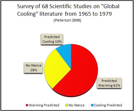
-
November 2025 general discussions and probable topic derailings ...
Cobalt replied to Typhoon Tip's topic in New England
In case the big graph scared you away from reading the text in that post. Also.. Believe what you want? It's a graph, believing implies there's a leap in the logic there. You could have stuck a thermometer right there in Southington and tracked it up until the present day and found the exact same thing. -
November 2025 general discussions and probable topic derailings ...
Cobalt replied to Typhoon Tip's topic in New England
Two things can be true at the same time. It certainly can still snow plenty in November and December, but increasing temperatures have made it just a bit more difficult as time goes on.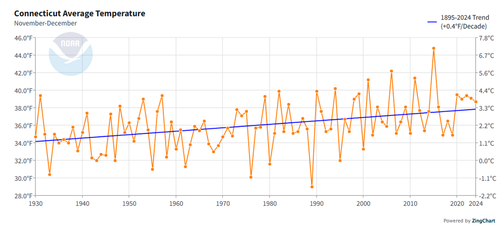
-
You expected to find the complete facts from a timespan that runs exclusively from January 1st to February 21st?
-
Still wondering about this. Why did you criticize the national temperature map for "only including March to August" when you previously posted/backed a map which only included January 1st-February 21st?
-
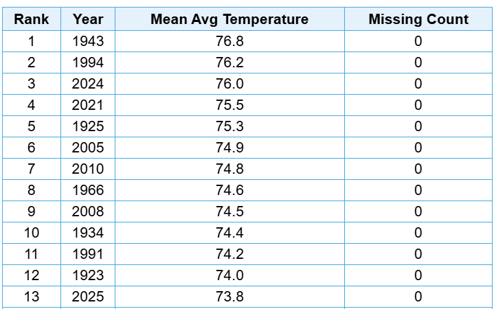
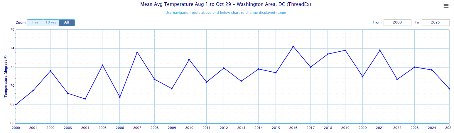
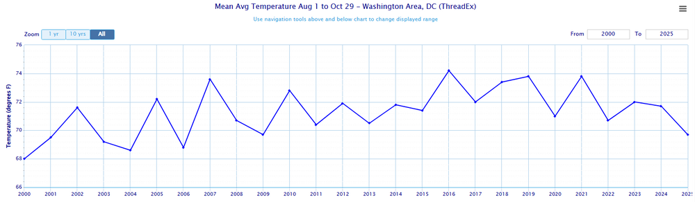
The period starting August 1st through now is tied with 2009 for the coolest such period since 2006 at DCA, with an average temperature of 69.7 Degrees. T-6th Coolest in the last 25 years, though it falls to T-17th Coolest in the last 50 years.
-
Major Hurricane Melissa - 892mb - 185mph Jamaica landfall
Cobalt replied to GaWx's topic in Tropical Headquarters
Ramped up even more since this message, that utility pole in the distance is really swaying now. -
Spooky Season (October Disco Thread)
Cobalt replied to Prismshine Productions's topic in New England
Why not? -
this is the question
-
It’s not a difficult question to answer
-
This is entirely unrelated to the discussion we were having above. I’ll ask the question again. Why did you call me out for “only including” a timespan from March to August when it was in response to you posting a map that only included January and February data? Why are you redirecting the conversation from national data to just specifically Chester County in the first place?
-
Because you claimed the "cooling period" started in January and February, so I wanted to roll forward that "cooling period" to the months afterwards, but I couldn't find it. To answer your question from February (where you chose to only include a map from January through February 21st) No, it is not.

-
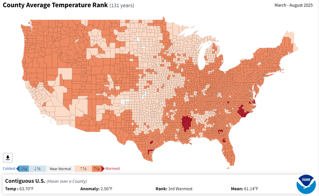
Since the start of this supposed cyclical cooling cycle the CONUS has seen its 3rd warmest March-August period in 131 years. September data isn't in yet but I'd assume that it will bump that ranking even higher.

-
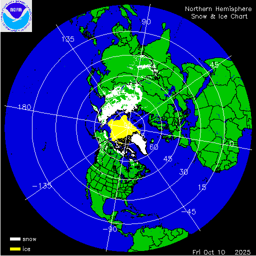
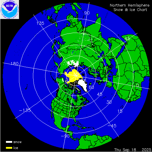
Impressive contrast. Siberian snow cover extent nearing record highs for the date, while the Northern Hemisphere is nearing a record low. Both regions are expected deviate from their extreme anomalies in the next week or so.
-
The return of the elusive Nor'easter. Drought buster or bust?
Cobalt replied to dailylurker's topic in Mid Atlantic
Last bonafide one was during October 2017 IIRC -
At the very least snowman has some substance behind his messages. qg_omega is just a troll.
-
Snow cover getting off to an early start, with favorable conditions for expansion during the next 2 weeks.
-
This would track well with Barry being the alt account of banned member CurlyHeadedBarrett, who also played a persona filled with "Incel" language, and whose last profile picture was Elliot Rodger, a mass-murderer who is idolized in the same spaces as the "Barry Stanton" persona. Not to mention the numerous other similarities/idiosyncrasies that have been brought up already.
-
I get this much but then that makes the graph you responded with even more baffling and confusing.
-
What relevance does this have in relation to the graph Jenkins posted? To get back to the topic at hand, his graph shows very clearly why DC's snowfall has trended downwards since the late 1800s. Global temperatures are up, and in the case of Washington DC, that means winter temperatures are up and snowfall is down. Seeing as there is no reason to believe that global, and therefore local winter temperatures will trend down in the coming decades, snowfall averages will continue to decrease. It's literally that simple. A graph extending back to 500mya has no relevance in regards to discussion about ongoing temperature and snowfall trends, other than to perpetuate your agenda.
-
Okay, then let's just take the timeframe since 1960 since it probably has better data. If that's the case then in that 66 year data set, Pennsylvania has had its 1st, 2nd, 3rd, 4th, 5th, 6th, 10th, 13th, and 14th warmest June-Julys since 2005. Only one year in that timeframe has cracked the top 28 coolest June-Julys, 2009 (which is tied as 1st coolest) Nobody said anything about being scared here we're in a thread that in part is focused on predicting the upcoming temperatures for the winter months. It's important to remind ourselves that given current trends, warmer than average months are far outpacing colder than average ones. Betting on colder than normal is a losing battle, with recent reprieves like August 2025 becoming increasingly rare. While we're on the topic of winter, in that same 66 year (as you suppose, more accurate) data set with less filled in blanks, the 1st, 2nd, 4th, 5th, 6th, 7th, 8th, and 11th warmest winters for Pennsylvania have all happened since 2002. So 8 winters cracking the top 12 warmest, while in that time only 3 winters have cracked the top 12 coldest. It's easy to tell why qg_omega and snowman bet on warm winters nearly every year nowadays, by an ever-increasing margin, they are right. The winter chill of many here's youths is becoming increasingly infrequent
-
NOAA's official website has June-July as 3rd warmest, only behind 1949 and 1934 https://www.ncei.noaa.gov/access/monitoring/climate-at-a-glance/county/mapping/36/tavg/202507/2/anomaly Important to note that it also shows that the 5th, 6th, 7th, 8th, and 10th warmest June-Julys for Pennsylvania have all happened since 2005.
-
How's this looking? From what I can tell Greensboro is at 74.1F as of August 27th. Looks like the final few days will pull the month incredibly close to Aug '92.
-
Is that not exactly you're doing by using just the years within the 1991-2020 average and nothing else? If not changing the standards, it's focusing only on the ones that push your notions. You're dropping 100 of the 136 years of records because they make this year's averages seem warmer by comparison. Would you look back on June 2025's +1.3 as a "cooler" month just because the 2001-2030 averages might place it as a -0.2, even if it ranks 20th warmest of 136 years?
-
Are you telling me that this wording Wasn't meant to push any sort of agenda that this Summer was not as warm as others claim? bluewave brought up that you're comparing against the warmest 30 year average, which is a completely valid criticism. From what I can tell June's "only +1.3" is 13th warmest out of 136 years. Words like "only" or "barely AN" are only applicable if we isolate the current 30 year average as the baseline for absolute warmth or cold. That is way more narrow of a scope than what bluewave did, comparing to the entire range of years. Comparing against 136 years is a way better benchmark than just 30.