Cobalt
-
Posts
5,218 -
Joined
-
Last visited
Content Type
Profiles
Blogs
Forums
American Weather
Media Demo
Store
Gallery
Everything posted by Cobalt
-

The Jan 31 Potential: Stormtracker Failure or 'Tracker Trouncing
Cobalt replied to stormtracker's topic in Mid Atlantic
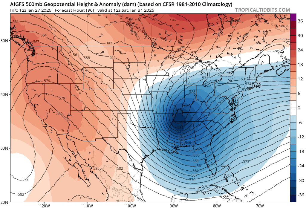
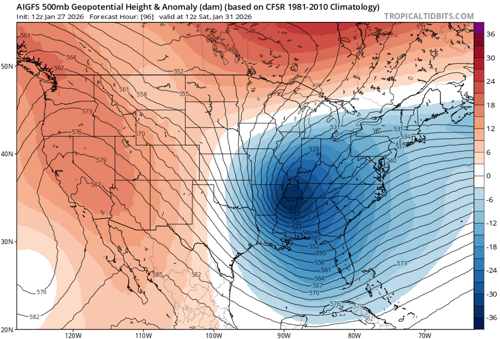
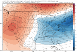
AI GFS looks a tick Northwest? At least at h500 and with that initial slug of precip. -
The Jan 31 Potential: Stormtracker Failure or 'Tracker Trouncing
Cobalt replied to stormtracker's topic in Mid Atlantic
Better trough orientation than 12z but considering that 12z was uber OTS that ain't gonna cut it -
The Jan 31 Potential: Stormtracker Failure or 'Tracker Trouncing
Cobalt replied to stormtracker's topic in Mid Atlantic
Some of this seems to be timing also? RGEM looks to be a few hours slower with the entire sequence of events than it was for 18z. -
The Jan 31 Potential: Stormtracker Failure or 'Tracker Trouncing
Cobalt replied to stormtracker's topic in Mid Atlantic
Weren't you just talking to a robot asking it to share secrets about the Weathernext's 18z run? -
The Jan 31 Potential: Stormtracker Failure or 'Tracker Trouncing
Cobalt replied to stormtracker's topic in Mid Atlantic
Why are we going through the individual members of an AI ensemble -
The Jan 31 Potential: Stormtracker Failure or 'Tracker Trouncing
Cobalt replied to stormtracker's topic in Mid Atlantic
h500 at hr 72 is a stone's throw away from the GFS solution. -
The Jan 31 Potential: Stormtracker Failure or 'Tracker Trouncing
Cobalt replied to stormtracker's topic in Mid Atlantic
There is effectively no way for Gemini to not only have direct and up-to-date information on the Weathernext 2.0, but also to be able to disseminate that information into snowfall ranges. -
The Jan 31 Potential: Stormtracker Failure or 'Tracker Trouncing
Cobalt replied to stormtracker's topic in Mid Atlantic
Google's AI model I believe. It got some credit for latching onto the northwest trend for this past weekend's storm pretty early on. I believe it's available on StormVista? -
https://www.weather.gov/lwx/wintermaps
-
The inclusion of the middle name really adds credence, nice touch
-
So incredibly easy to extrapolate what a similar shift at 0z would do.. Let's hope the Euro can fill in the blank for us
-
How does this compare to 12z?
-
I recall when it hallucinated a threat back in late Jan 2021.. went bonkers for a few runs with the operational and ensemble snowfall totals then completely lost it. That was at like hr 132 though, so this would be something else.
-
-
Easier to bring it due North than due West at this range at the very least
-
RGEM honestly not too far off of GFS at hr 84
-
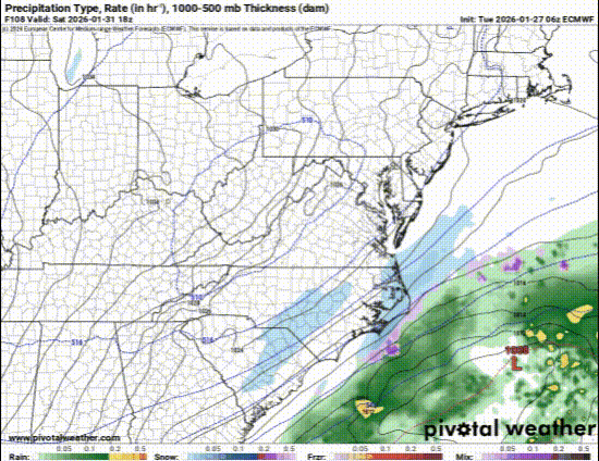
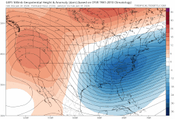
AI GFS looks like a slight step back on the coastal. Still further west than AI Euro, and it also has that initial slug of moisture further North to start. As others have noted, that might be a way to salvage a small snowfall if the main event fails to develop.
-
NS lobe is definitely further West than 12z through 72, but doesn't look like it's gonna get its act together.
-
In recent memory, it feels like the Euro is most fallible past hour 120+, and the GFS is most fallible within that range. Makes perfect sense then that the Euro showed a favorable solution at that range only to trade places with the GFS as we got closer. Anyways.. Euro AI shows a small event on the 5th
-
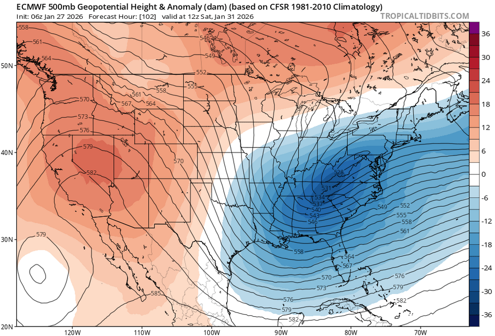
The AI Euro and GFS are remarkably similar at h500 and also precip extent. Comparing them to the 6z Euro indicates that, while an amped solution isn't expected or even likely, the 6z Euro is likely an outlier in how disorganized it is.
-
AI GFS is more amped/more west with the trough than 6z, continuing a 4+ run trend Euro at the same time for comparison
-
pretty good GEFS trend.
-
Translates to a 25-50 mile shift northwest. Not a hit, but a least a step. 0z yesterday was 200 miles + offshore
-
AI GFS continuing its trend of shifting the trough West
-
It had that northern stream component notably West early on into the run like NAM and Euro, but then yeah the entire look fell apart.