-
Posts
5,205 -
Joined
-
Last visited
Content Type
Profiles
Blogs
Forums
American Weather
Media Demo
Store
Gallery
Everything posted by Cobalt
-
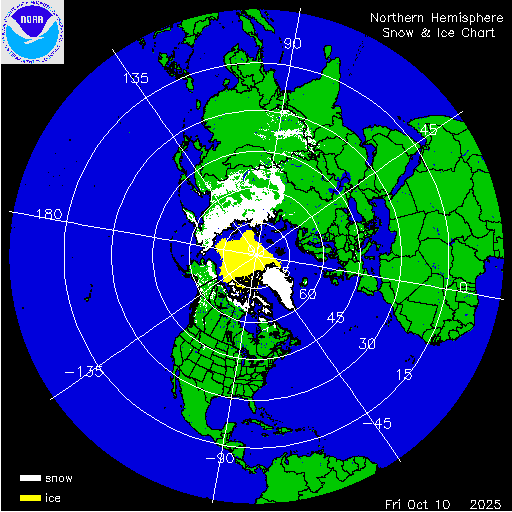
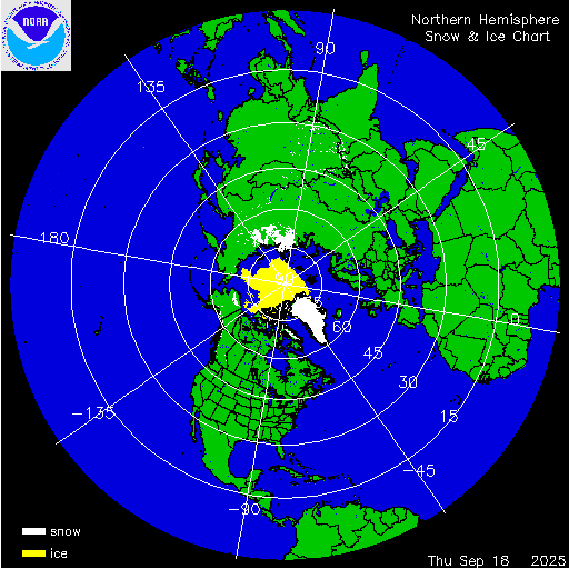
Impressive contrast. Siberian snow cover extent nearing record highs for the date, while the Northern Hemisphere is nearing a record low. Both regions are expected deviate from their extreme anomalies in the next week or so.
-

The return of the elusive Nor'easter. Drought buster or bust?
Cobalt replied to dailylurker's topic in Mid Atlantic
Last bonafide one was during October 2017 IIRC -
At the very least snowman has some substance behind his messages. qg_omega is just a troll.
-
Snow cover getting off to an early start, with favorable conditions for expansion during the next 2 weeks.
-
This would track well with Barry being the alt account of banned member CurlyHeadedBarrett, who also played a persona filled with "Incel" language, and whose last profile picture was Elliot Rodger, a mass-murderer who is idolized in the same spaces as the "Barry Stanton" persona. Not to mention the numerous other similarities/idiosyncrasies that have been brought up already.
-
I get this much but then that makes the graph you responded with even more baffling and confusing.
-
What relevance does this have in relation to the graph Jenkins posted? To get back to the topic at hand, his graph shows very clearly why DC's snowfall has trended downwards since the late 1800s. Global temperatures are up, and in the case of Washington DC, that means winter temperatures are up and snowfall is down. Seeing as there is no reason to believe that global, and therefore local winter temperatures will trend down in the coming decades, snowfall averages will continue to decrease. It's literally that simple. A graph extending back to 500mya has no relevance in regards to discussion about ongoing temperature and snowfall trends, other than to perpetuate your agenda.
-
Okay, then let's just take the timeframe since 1960 since it probably has better data. If that's the case then in that 66 year data set, Pennsylvania has had its 1st, 2nd, 3rd, 4th, 5th, 6th, 10th, 13th, and 14th warmest June-Julys since 2005. Only one year in that timeframe has cracked the top 28 coolest June-Julys, 2009 (which is tied as 1st coolest) Nobody said anything about being scared here we're in a thread that in part is focused on predicting the upcoming temperatures for the winter months. It's important to remind ourselves that given current trends, warmer than average months are far outpacing colder than average ones. Betting on colder than normal is a losing battle, with recent reprieves like August 2025 becoming increasingly rare. While we're on the topic of winter, in that same 66 year (as you suppose, more accurate) data set with less filled in blanks, the 1st, 2nd, 4th, 5th, 6th, 7th, 8th, and 11th warmest winters for Pennsylvania have all happened since 2002. So 8 winters cracking the top 12 warmest, while in that time only 3 winters have cracked the top 12 coldest. It's easy to tell why qg_omega and snowman bet on warm winters nearly every year nowadays, by an ever-increasing margin, they are right. The winter chill of many here's youths is becoming increasingly infrequent
-
NOAA's official website has June-July as 3rd warmest, only behind 1949 and 1934 https://www.ncei.noaa.gov/access/monitoring/climate-at-a-glance/county/mapping/36/tavg/202507/2/anomaly Important to note that it also shows that the 5th, 6th, 7th, 8th, and 10th warmest June-Julys for Pennsylvania have all happened since 2005.
-
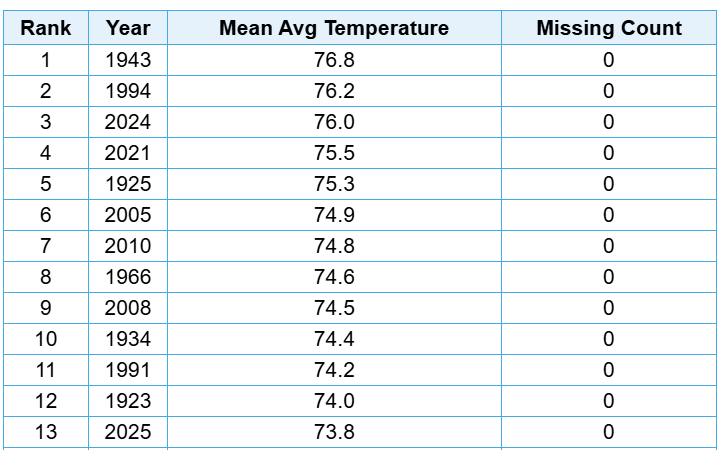
How's this looking? From what I can tell Greensboro is at 74.1F as of August 27th. Looks like the final few days will pull the month incredibly close to Aug '92.
-
Is that not exactly you're doing by using just the years within the 1991-2020 average and nothing else? If not changing the standards, it's focusing only on the ones that push your notions. You're dropping 100 of the 136 years of records because they make this year's averages seem warmer by comparison. Would you look back on June 2025's +1.3 as a "cooler" month just because the 2001-2030 averages might place it as a -0.2, even if it ranks 20th warmest of 136 years?
-
Are you telling me that this wording Wasn't meant to push any sort of agenda that this Summer was not as warm as others claim? bluewave brought up that you're comparing against the warmest 30 year average, which is a completely valid criticism. From what I can tell June's "only +1.3" is 13th warmest out of 136 years. Words like "only" or "barely AN" are only applicable if we isolate the current 30 year average as the baseline for absolute warmth or cold. That is way more narrow of a scope than what bluewave did, comparing to the entire range of years. Comparing against 136 years is a way better benchmark than just 30.
-
Both 2-4°C of warming and cooling at the current pace of anthropogenic warming would be catastrophic. Non-transient changes like that do not happen at that sort of rate. Leaving out a time factor in the polls is in poor practice, because it creates a hypothetical environment of set warming or cooling with no time horizon. I think it's better to ask, if we were instead on pace for 2-4°C of cooling by the end of the century, and we knew we were the cause, would we try to pause that trend by mitigating our actions?
-
3F below normal compared to 1991-2020 averages, the warmest 30 year set. In 2024, 2023, and 2020, the nation blew past 3F above normal during the exact same stretch like nothing. Where were you posting the national temp anomaly maps then?
-
Light snow, 15F
-
We're sick and twisted individuals
-
It torched in December. Pretty sure if not for 2015, Dec 2021 would be the warmest at the 3 airports. That made a BN DJF average impossible, but January-April were pretty chilly as far as La Ninas go.
-
damn this thing must be a powerhouse if it's snowing all the way from 50mb
-
Feb 26-27 2004 says hi
-
My personal favorite - can you guess which winter this post followed? let me give a hint, it starts with an 09 and ends with a -10
-
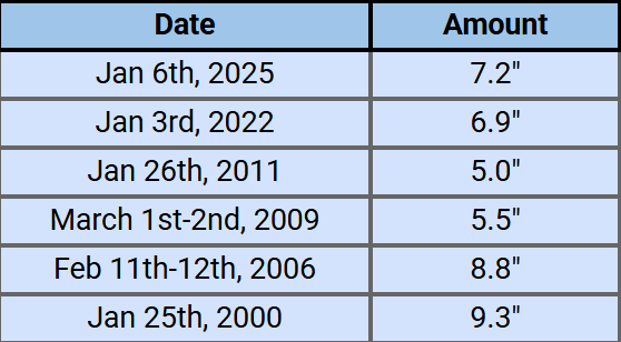
Worth bringing up because this isn't all too far fetched at this point. Listed are all the 5"+ snowfalls at DCA during 21st century La Niñas. The last La Niña to feature 2+ snows above 5 inches was 95-96 (3 instances), so the slight chance of DCA not DCAing today would have this winter be the first in nearly 30 years to join that club.
-
Your file size is limited by other files you've uploaded. On desktop click on your name in the top right, then click "my attachments" (should work on mobile too). Delete the files taking up the most space but definitely save them to your device beforehand. A bunch of lost media over the years all because of an understandable file limit.
-
-
La Ninas of years past have produced eerily similar fails. Folks might remember that one mid Feb 2021 threat (also February 12th I think?) that had two waves to it. Guidance converged on both waves producing a flush hit from 100+hrs out and I think even the Euro within hour 70 had a widespread 6-12". However, the same 1st wave weak second wave too strong thing happened. It is excessively difficult to put stock in these multi-wave solutions when there is so much give and take to how the guidance places emphasis on either phase of the thing.
-
Just gotta wait a few weeks my friend. Mid February onwards looks cold and snowy!


