

Cobalt
-
Posts
5,216 -
Joined
-
Last visited
Content Type
Profiles
Blogs
Forums
American Weather
Media Demo
Store
Gallery
Everything posted by Cobalt
-

January 24-26: Miracle or Mirage JV/Banter Thread!
Cobalt replied to SnowenOutThere's topic in Mid Atlantic
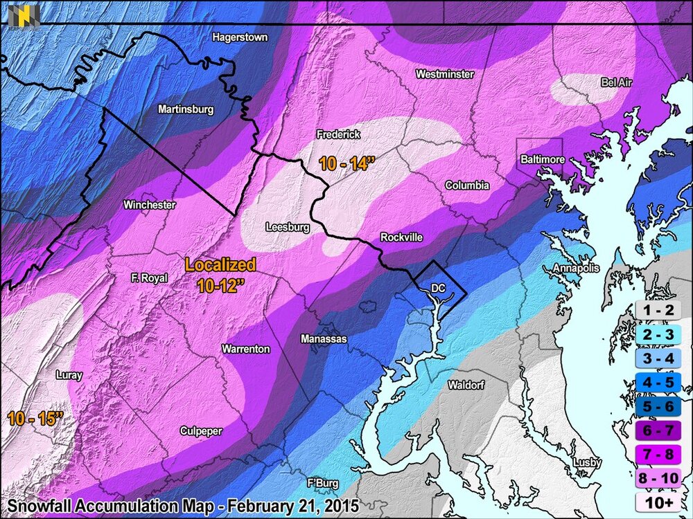
Looking back at the Feb 21, 2015 storm someone mentioned in the other thread.. woof, quite the boom. Let's hope a similar thump is in store this time around, but area-wide. Accompanying article for anyone interested https://www.washingtonpost.com/news/capital-weather-gang/wp/2015/02/22/the-meteorology-behind-saturdays-multiple-choice-winter-storm/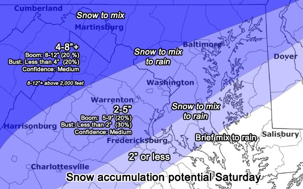
-
More confluence out ahead, slightly weaker ridge. Nowhere near that ridiculous 0z solution yesterday.
-
Despite the atrocious look out west, the phase is a tad sloppier. That combined with the improved thump puts down 0.8" QPF in DC before sleet enters the picture.
-
Just going through the memory bank of similar WAA-driven events, I recall how amped the NAM suite was for the Dec 16-17 2020 junction. Their first runs at range scoured out any cold air at 700/850mb well to the northeast, an extreme NW outlier. They were the first warning signs for that event, and while the other (less amped) guidance didn't completely cave to their long-range looks, they did conform to its depiction of warm quickly scouring out the relatively weak CAD signature. That makes me wonder if the 12k NAM isn't completely off its rocker with its current depiction.
-
slight decrease since 12z, certainly cant hurt, though probably related to timing differences also.
.thumb.gif.8b29707c04340b63b9b05bde891ce79e.gif)
-
January 24-26: Miracle or Mirage JV/Banter Thread!
Cobalt replied to SnowenOutThere's topic in Mid Atlantic
Record low hunting next Tuesday?.thumb.png.330d57d8d6411ecb166b0559a8c99298.png)
-
Northern stream is running out a good bit further ahead than 12z, which I assume is a good thing
-
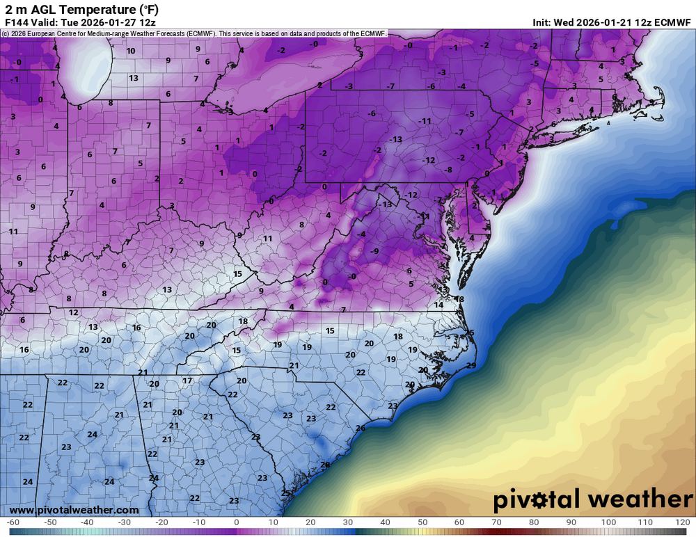
Genuinely absurd temperature output by the Euro after our system. I get that it can be overdone, especially with snowpack, but even if you add 10 Degrees to every low temp it says DC hits single digits 3+ times this upcoming week. Would love to see the City charts from weathermodels if someone has access to that, it's a frame-worthy output.
-
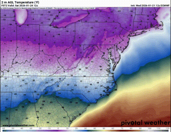
Your standard 10/-11F day in DC as forecast by the 12z Euro. Call me skeptical but I don't think we'll see DC's 3rd ever subzero daily average.
-
Sure, why not
-
Looks effectively identical to 0z's output, though definitely subtracted a bit East of DC.
-
10% luck, 20% skill, 15% concentrated power of will?
-
Wow, this clearly shows that record highs have been outpacing record lows at a near 4:1 or 5:1 rate since 2020. Even at the apex of record highs in the 1930s the ratio was only 3:1 at max. Chris Martz is incredibly agenda-driven so that is likely why he didn't accompany this graph with one showing the ratio of high to low records, it would've dismantled his entire argument. Instead he has to rely on big scary numbers and his audience's lack of critical thinking, which is a pretty easy thing to bank on.
-
0z drove the primary into Buffalo so this is decisive improvement.
-
It's not the GFS, that's for sure.
-
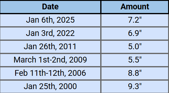
Even just modest snowstorms in La Ninas are rare and to be appreciated any time they happen. This is missing Feb 12th from last year, but here's a list of every 5"+ La Nina snowstorm at DCA in the 21st century. The 2010s had just one instance.
-
Rise of the Machines: January 18-19 Winter Storm Obs Thread
Cobalt replied to WxWatcher007's topic in New England
@qg_omegahas the easiest job on planet earth in predicting warm East coast winters and has been wrong 2 years running. After predicting record warmth last winter and being off by 5+ degrees I’d have hopped over to the basket weaving forum if I was him. At least there’s less of a chance of being wrong over there. -
Where's your mention of all of the cities in the Western US that have had record warm starts to the winter?
-
Wow, 6F per century if this trend line continues.
-
this post title from after that winter sums up Ji's entire persona quite well

-
Out in weenie land but Euro showing a high of 3F for DC on the 27th and a low of -10F on the 28th. Can't see I've seen that modeled by the Euro at any range lol
-
Boston is running 5.1F colder than 1931-32 at this point in the winter.
-
CAPE storm back in 2022. GFS was the only one giving that storm a chance up until like 54 hours out. Euro jumped from nothing down to Virginia Beach all the way to 8"+ in DC in maybe 3 runs.
-
Who doesn't love it when the NAO enters the middle of the country and disrupts the fried eggs coming out of the gulf?

-
snowman19 only responding in emojis? Why, what happened?


.gif.e25a8b968d9bc6266d7a76272d673c05.gif)
.png.f32b293801186e9d4ece43c45c7d8309.png)


