Cobalt
-
Posts
5,221 -
Joined
-
Last visited
Content Type
Profiles
Blogs
Forums
American Weather
Media Demo
Store
Gallery
Everything posted by Cobalt
-
This is almost certainly survivorship bias. Few here might remember the string of runs from the Euro and GFS and their ensemble counterparts from the week before that, showing a massive overrunning event that fizzled out at medium range.
-
Snow was sparse, but those winters were on average much colder than than the below average snowfall winters of recent. A colder/dryer look versus the warmer that we've become accustomed to. The warmest winter in all of the 80s for the Northeast would've been the 4th coldest of the past 10 years.
-
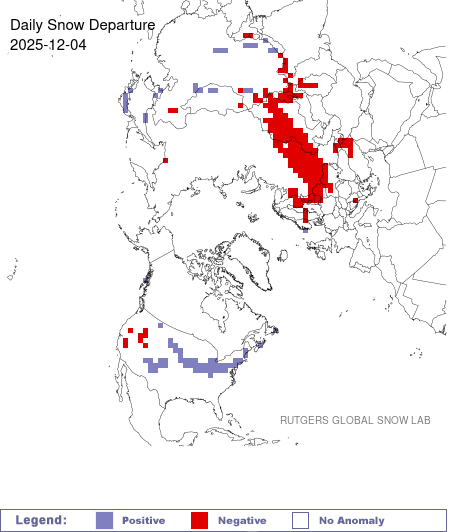
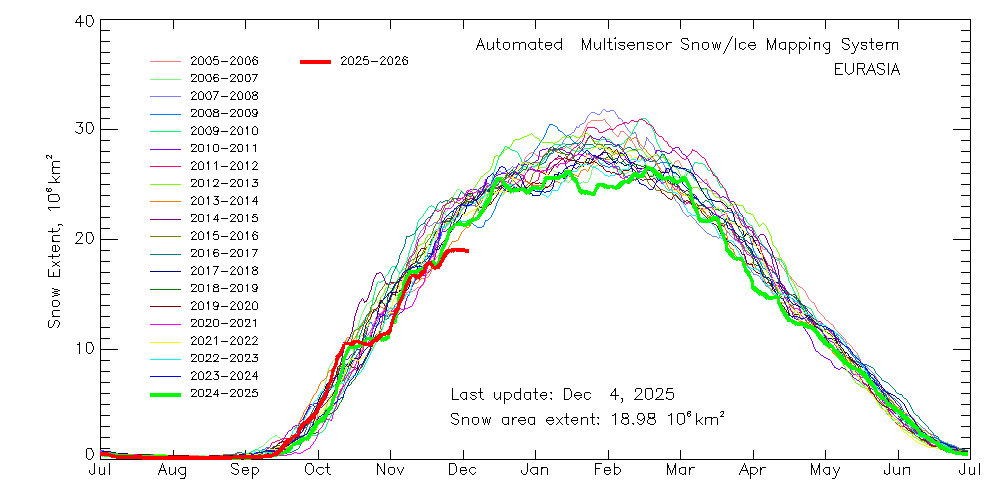
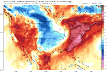
The United States is just a small part of the northern hemisphere's cryosphere. Overall, NHem snow cover is still at a record low for the date. This is in large part due to that huge deficiency in Eastern Eurasia, some 3x the surplus in the US. Eurasian snowcover growth is at a standstill.
-
That's a first.. a modeled underperformer
-
26F with light snow in Harrisonburg. Coating to an inch on most surfaces, and starting to accumulate on the parking lot pavement. Going for a walk when a batch of moderate snow moves through in a bit.
-
This is a true sentiment. I guess what I was getting at was that 24/25 of the past Decembers have been in that second camp, some bolstered by the fact that they do not need to be as cold as December 2017 to see prolific winter conditions. I agree with you on the last part. Cold and snowy times are already an infrequent part of an infrequent season. We deserve to enjoy the times where winter shows its true hand.
-
They run off of 30 year normals. Most sites run off of 1991-2020 averages, which were a step up from 1981-2010 averages, which were a step up from 1971-2000 averages. Im surprised nobody's made a tool to show what specific months or years would look like using modern 30 year averages vs older ones.
-
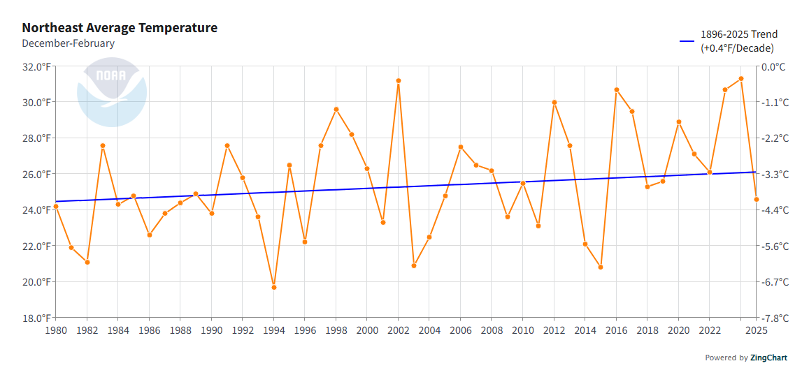
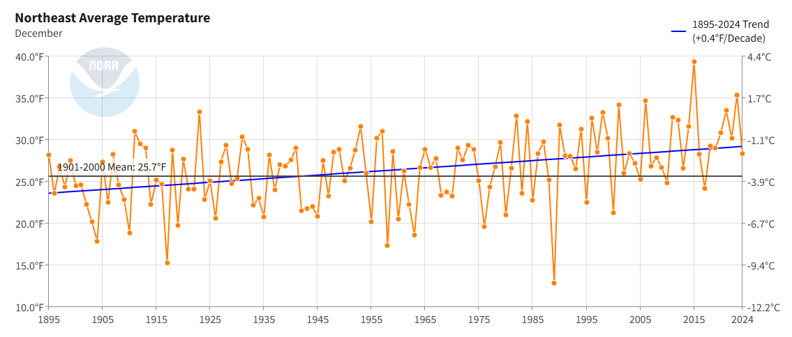
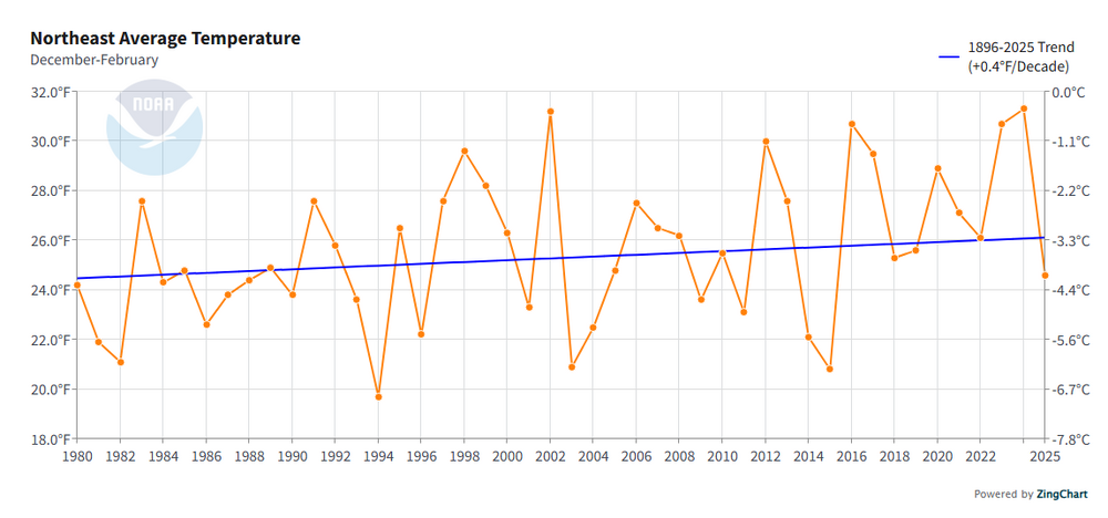
I took a look at the normals. Northeast Decembers as cold as the coldest one of the 21st century (Dec 2017, 24.2F) used to occur an average of 1 every 2.83 years from 1895-2000.

-
1.6" at DCA would be the snowiest December event for the airport in 16 years. Guidance says to take the under but certainly not off the table.
-
I recall the Feb 16-17 2015 event being sold as a 6-10"+ event solely because of it was progged to have 0.3-0.5" of precip fall in a brutally cold airmass. That was around when kuchera was beginning to get attention, but come game time the snow growth was terrible and grainy, and ratios were much closer to 10:1.
-
6z Euro tops out at 28F for the 5th at DCA. Almanac data says the daily record low max is 25F from 1886. A day later and it would be threatening that record low max of 29F (1910).
-
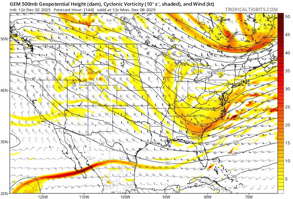
Past two runs have had increasing separation between the southern and northern waves. That looks like an ample route to a success scenario.

-
The entirety of this piece is AI generated. The header image, the article's author "Dylan Hartwell", and the full contents of the piece. Every single paragraph has the hallmarks of a ChatGPT-fed prompt. No need to source robot weenies for the December forecast, we have plenty here who will do that job for you for free
-
The sentiment is appreciated, even if you had to use ChatGPT to write it for you 34F at 12:30am with a forecast low of 23.
-
but I thought..
-
Hard to tell with the limited PivotalWX panels, but it appears as if the EPS backed off a bit from the greater +EPO it showed at 0z for the D7+ range.
-
As opposed to the brutal 4-5-6 response from last year?
-
Sunday's storm has trended a few mb stronger which seems to help confluence linger around for a bit longer.
-
12z GFS shows -4C 850 temps at 6z Tuesday for DCA. 0z had +2C during the same timeframe.
-
An excellent call once again
-
Not really that crazy, the same thing happened in Feb 2018.
-
only up to 38F at 1:30pm
-
BWI: 18.6" DCA: 9.7" IAD: 15.3" RIC: 8.2" Tiebreaker SBY: 8.4"
-

November 2025 general discussions and probable topic derailings ...
Cobalt replied to Typhoon Tip's topic in New England
Ryan Maue purposefully uses language like this to generate reactions on social media, particularly from people who use such tweets as examples of anthro climate change proponents being "extremists" or "doomists". It's funny, because beneath that veil he likely is more aligned with the people who get reactionary when he uses such phrases as "climate breakdown". He served as the chief scientist at NOAA under Trump, and at the time was known for minimizing humanity's role in recent climate trends. Maybe that implies that there's a good bit of sarcasm in that tweet's wording, but it is not the first time he's done such a thing. -
November 2025 general discussions and probable topic derailings ...
Cobalt replied to Typhoon Tip's topic in New England
Obviously that's done nothing to the climate because in Antarctica it's gone from unfathomably cold to just ridiculously cold.