Cobalt
-
Posts
5,216 -
Joined
-
Last visited
Content Type
Profiles
Blogs
Forums
American Weather
Media Demo
Store
Gallery
Everything posted by Cobalt
-
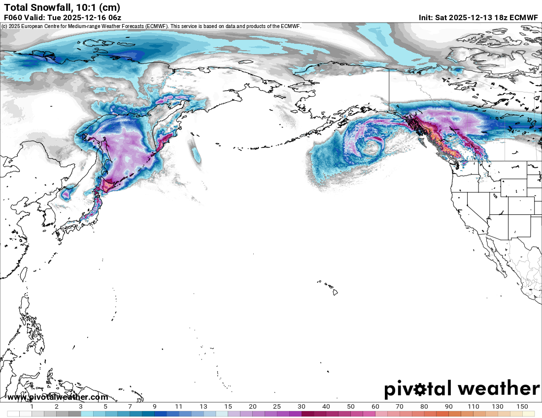
Euro AI Ensemble features BN 850 temperatures from hour 228 through the end of the run. Its accuracy at range was dubious during the overwhelming -WPO regime, but perhaps this will be a better test for it.
-
What do the median numbers look like? I recall you posting those numbers from pivotal a while back (I believe it's a Pivotal+ exclusive). I'm guessing there's a handful of members who go extreme with the SE ridge and pump big AN anomalies, while the colder scenarios provide pedestrian, yet serviceable cold that does little to revert the mean. Just a guess.
-
I forget who it was exactly, but during the 2020-2021 winter someone ran the numbers on "snowless" mid-winter stretches at DCA and found that virtually every year in the modern era had at least one 30-45 day break between snowfalls. A few of the analog winters had even more prolific stretches, such as 2005-2006's 58 day break. I suppose that these types of breaks are more stressful in La Ninas because of how snowfall climo runs downhill as winter progresses, but the latter halves of 05-06, 17-18, and even last winter show that this is not always the case.
-
-
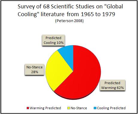
Not according to the academic literature of the time, but I can see how selective memory would only hold onto the predictions of cooling.
-
Only 10% of the literature even suggested the idea of predicting global cooling (while 62% predicted warming), but sure. Remember what you want to remember
-
I don't mean to act like I'm not actively refreshing the kuchera panels as we speak
-
We're looking at maps so distant in time that quantum computing might come out and improve model accuracy x100 times over before the event actually gets to our doorstep
-
August 1st through December 21st has averaged 60.7°F at DCA, the coldest for that stretch since the year 2000 (58.4°F), and 1.5°F below the 30 year average.
-
-
BWI has just recorded its 10th coldest 1st half of December, with an average temperature of 31.4F. DCA comes in at 19th coldest (34.4F) Just as compelling are the stats for max daytime temperatures so far this month. BWI's mark of 45F ties with 1904 for the lowest high temperature seen in the first half of December. DCA 2nd lowest (46F). As for the upcoming warmup.. DCA's 30 year average max temperature for the 2nd half of December is 64F, so what might feel like a Holidays "torch" is actually not too uncommon.
-
looks better than 12z from this angle

-
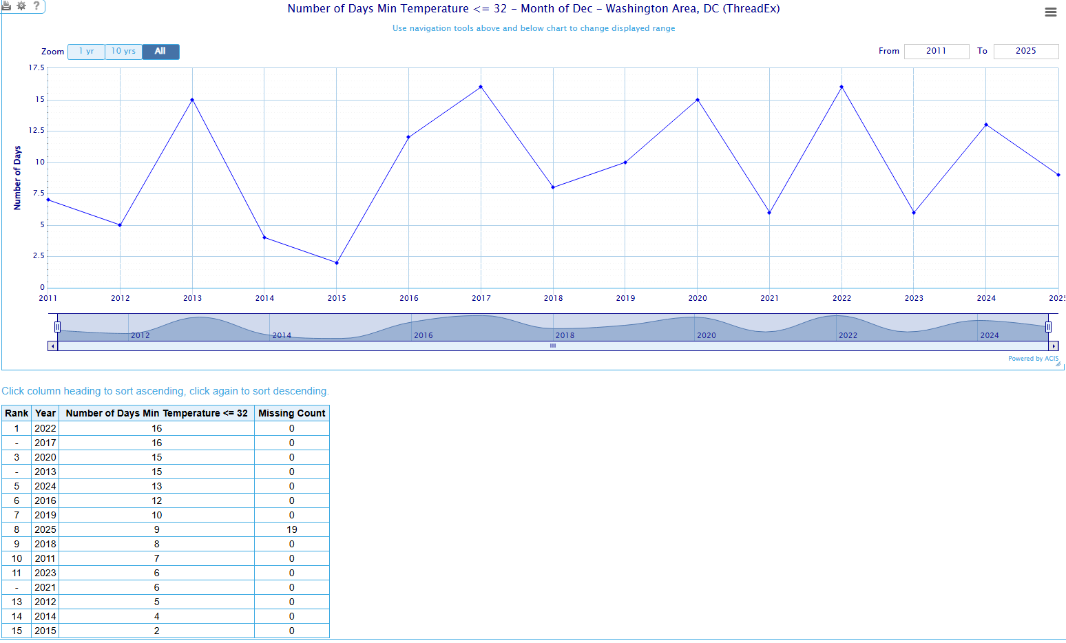
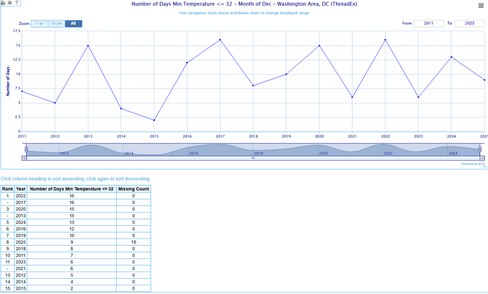
12 days into the month (today's stats are yet to be added), DCA has seen 9 days feature subfreezing temperatures. That beats the entirety of Decembers 2023, 2021, 2018, 2015, 2014, 2012, and 2011. By the start of the mid-month warmup DCA will be tied with last December at 13. Still a decent chance that the airport tops 2022 for most subfreezing lows in December since 2010 (Towering above most years at 27 days)
-
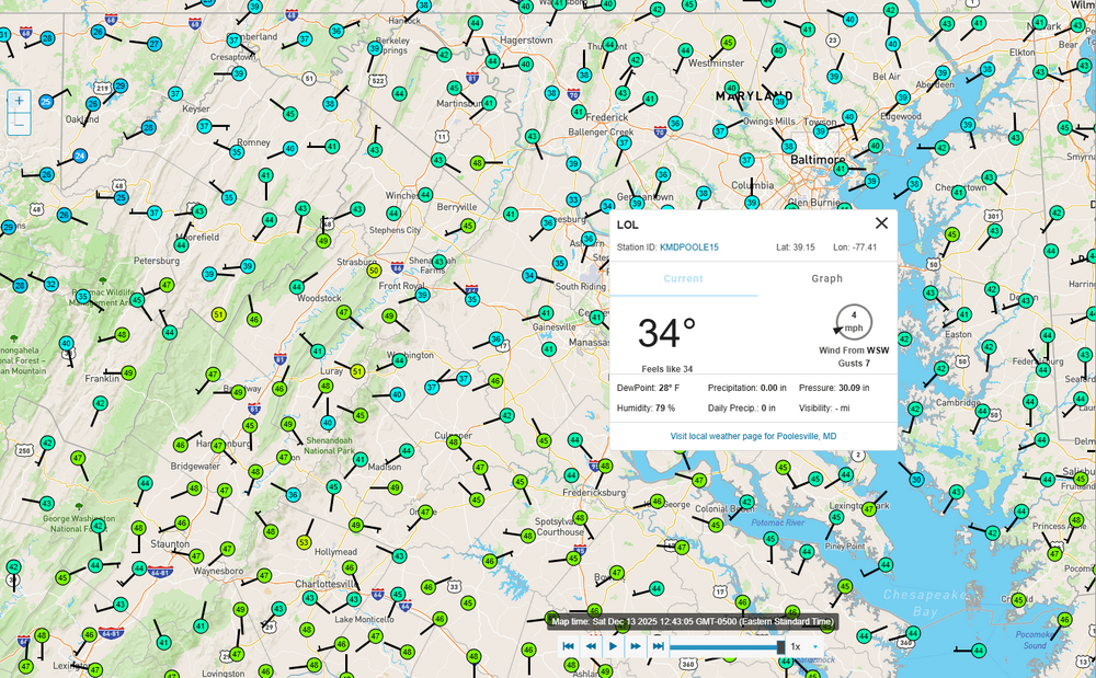
was checking area temps ahead of this system and.. whose station is this??
-
sure, why not.
-
I think he's interpreting it as NW just due to the perspective from his locale, but yeah precip on the whole took a 25+ mile jump due West from 6z. Maybe a slight North lean but more West than anything. Pretty happy that I'm back in McLean for the holidays for this one
-
Hi! Was wondering where you went, since it seems like you, qg_omega, and co go mia every time there's a snow or cold threat. Speaking of which, hope you enjoy the snow tomorrow. Seems like you and areas to your south near NYC are game for an appreciable December snowfall.
-
You know who
-
Sounds like a bit of gambler's fallacy also.
-
2F off of the record set in 1989, impressive.
-
Still waiting for your very warm post-Thanksgiving pattern to start showing up..
-
This is almost certainly survivorship bias. Few here might remember the string of runs from the Euro and GFS and their ensemble counterparts from the week before that, showing a massive overrunning event that fizzled out at medium range.
-
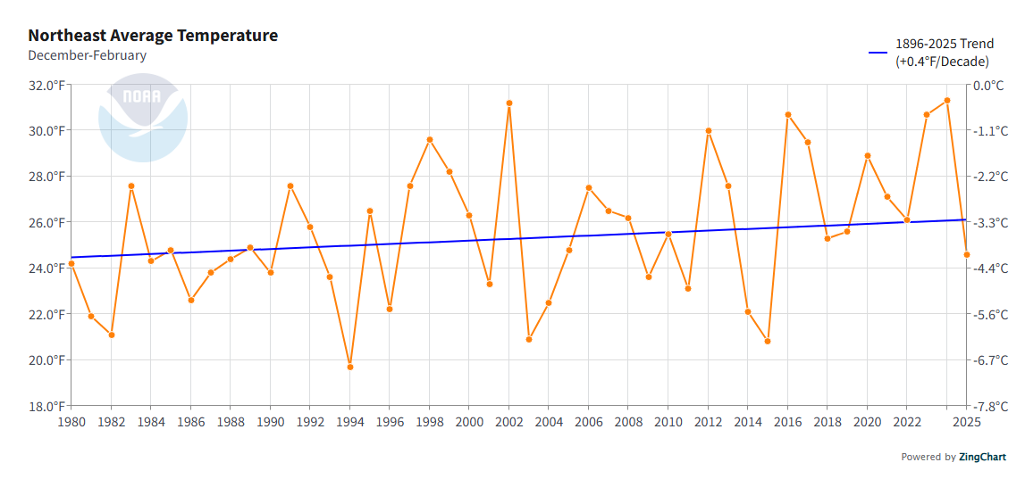
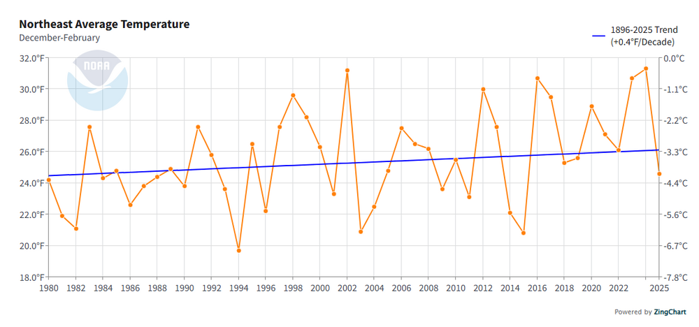
Snow was sparse, but those winters were on average much colder than than the below average snowfall winters of recent. A colder/dryer look versus the warmer that we've become accustomed to. The warmest winter in all of the 80s for the Northeast would've been the 4th coldest of the past 10 years.
-
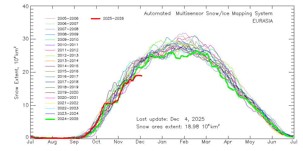
The United States is just a small part of the northern hemisphere's cryosphere. Overall, NHem snow cover is still at a record low for the date. This is in large part due to that huge deficiency in Eastern Eurasia, some 3x the surplus in the US. Eurasian snowcover growth is at a standstill.
-
That's a first.. a modeled underperformer