All Activity
- Today
-
Texas 2024 Discussion/Observations
Stx_Thunder replied to Stx_Thunder's topic in Central/Western States
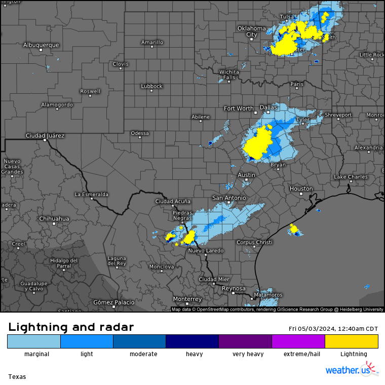
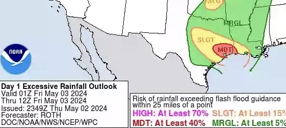
Definitely looks like some more flooding in East TX early this morning. Especially in Huntsville area and/or just north/east of Houston area once again with that next MCC upstream moving fairly slow southeast (just south of DFW area). But intensity could be limited overall this time with all of last night’s activity causing some stability in that part of the state. Though FFGs (flash flood guidance values) are already very low around Huntsville area and pretty much all around there too, so it won’t take much more rain at all now. WPC maintaining Moderate risk in Houston area, but 850mb flow is now apparently (but modestly) deep out of the southwest on Houston VWP radar so that’s probably going to limit convective intensity a good amount with new development more likely further east unless an MCV comes right next to Houston. Tonight’s 0z ARW run has a fairly good handle on the ongoing thunder system in north-central part of state moving through most if not all of SETX in some organized form later this morning (some remnant boundaries from yesterdays activity in the area to work with also around there).

-

Severe Weather 4-30-24 through 5-2-24
stormdragonwx replied to cstrunk's topic in Central/Western States
Man 2024 is turning to be a pretty epic plains year, its been too long. -

2024 Short/Medium Range Severe Weather Discussion
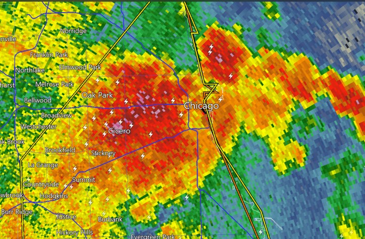
CheeselandSkies replied to Chicago Storm's topic in Lakes/Ohio Valley
Euro and to a lesser extent GFS have the left exit region punching right into southern WI/northern IL at 0Z Wednesday, but GFS has already put the front through with the best moisture shunted south/east. If the GFS's slightly too fast bias holds here, that could give those areas higher potential at the expense of IN/OH. Of course, my backyard bias is at play here since I'll be back home next week, but also back at work. Sent from my Pixel 8 using Tapatalk -
So there has been a consistent signal of severe weather for various portions of the subforum next week. Right now, Wednesday looks to be the day but Monday-thursday all show some potential. With multiple waves, it is going to be a complicated week. The only thing that we know at this point is that there will be more the sufficient upper level flow over a very favorable parameter space. Selected sounding is from west central ohio on wednesday. If this thread is premature, feel free to delete it.

-
Have had storms rolling through on and off for like the last 7 or 8 hours now. Nothing severe here really but the lightning was surprisingly good with this last wave. This really is a fun season overall, I can really get behind the storms every day or two
-

E PA/NJ/DE Spring 2024 OBS/Discussion
Rtd208 replied to Hurricane Agnes's topic in Philadelphia Region
High for the day was 89 here. Current temp 68 -
High for the day was 89 here. Current temp 68
-
Mowed the grass twice within 6 days 2 weeks ago... Has barely grown any since... No rain in 3 .5 weeks and these summer temps is really starting the drought going again... And there is no doubt the drought has returned , less than 6 inches here since late January... Really really do need this weekend to come through in the Valley...
-
lightning and heavy rain coming in to downtown
-
Thank you, Toronto. Finally a game 7. Pulling for Nash and Vegas to move those series to a game 7. Firm believer in series going 6 minimum, the more hockey, the better.
-
And we were somewhere between you both. It was sunny early and it was nice but we clouded up and had a few sprinkles and the temps dropped. I thought we were going to get rained on playing golf tonight but it cleared off nicely.
-
Sixers started playing better when they stopped trying to force feed points from maxey.
-

Central Pa. Spring 2024
Itstrainingtime replied to mahantango#1's topic in Upstate New York/Pennsylvania
One I think is genuinely a good guy and the other was well, Buddy Ryan. -
Central Pa. Spring 2024
Itstrainingtime replied to mahantango#1's topic in Upstate New York/Pennsylvania
Sixers showing a little heart after getting punched in the mouth early. -
The most popular Buddy since Ryan.
-
Noticed the grass crunchy today and browning in areas.
-
Hit 90° today in Lebanon. Hit 90 or better twice this week not bad…down to 69° now
-
We need to get rid of this out of season blocking. Why don't we get these fronts in the winter?
-
I got 1.00" of rain today as a good band of stratiform rain moved through this morning. I'm still waiting for the first good thunderstorm of the year.
-
Next back door front is already on the way-you can see it on radar coming into the twin forks. Definitely was a nice day when the sun came out, but it was a bummer that the summer temps were a bust.
-
It was low 50s and showery with a ceiling around 2kft this afternoon. Did hit 61F at 11am but was all downhill from there with wet-bulb cooling in showers. Finally broke up and dried up rapidly between 5-6pm. Its crazy how comfortable it is as long as the sun is out. Even temps in the 50s feel all good when the sun is out. Coming out of winter, it all feels mild.
-
The sun came out just after 2 PM and it barely made a different in the temperatures which stayed in the 60s. But it was really nice, not cold and not hot. The skies were a very deep blue too.
-

Severe Weather 4-30-24 through 5-2-24
cheese007 replied to cstrunk's topic in Central/Western States
Gonna be a very close call for Abilene if this can put another tor down -
Kudos to the NAM and other models that kept the summer air at bay. It’s a tough call east of the city whenever there’s a back door/SE wind pattern. GFS had the wind turning westerly which never happened here. It did turn nice once the clouds finally broke but the barrier beaches probably stayed at 60 or below.
-
Love it!