All Activity
- Past hour
-

May 2024 Discussion - Welcome to Severe Season!!!!
RUNNAWAYICEBERG replied to weatherwiz's topic in New England
Everyone is praying the gfs is right with a full coc MDW. -
Tornado Warning for Allegheny County Issued by National Weather Service Pittsburgh, PA 4:40 PM EDT Fri, May 17, 2024 The National Weather Service in Pittsburgh has issued a * Tornado Warning for... East central Allegheny County in southwestern Pennsylvania... Northwestern Westmoreland County in southwestern Pennsylvania... * Until 515 PM EDT. * At 440 PM EDT, a severe thunderstorm capable of producing a tornado was located over Aspinwall, or near Penn Hills, moving east at 15 mph. HAZARD...Tornado. SOURCE...Radar indicated rotation. IMPACT...Flying debris will be dangerous to those caught without shelter. Mobile homes will be damaged or destroyed. Damage to roofs, windows, and vehicles will occur. Tree damage is likely. * This dangerous storm will be near... Penn Hills, Plum, O'hara Township, Oakmont, Fox Chapel, Aspinwall, Verona, and Blawnox around 445 PM EDT. Springdale around 450 PM EDT. New Kensington and Lower Burrell around 500 PM EDT. Arnold around 505 PM EDT. Other locations impacted by this tornadic thunderstorm include Cheswick. PRECAUTIONARY/PREPAREDNESS ACTIONS... TAKE COVER NOW! Move to a basement or an interior room on the lowest floor of a sturdy building. Avoid windows. If you are outdoors, in a mobile home, or in a vehicle, move to the closest substantial shelter and protect yourself from flying debris. Please report severe weather by calling 412-262-1988, posting to the NWS Pittsburgh Facebook page, or using Twitter @NWSPITTSBURGH. && TORNADO...RADAR INDICATED; MAX HAIL SIZE...0.00 IN
-
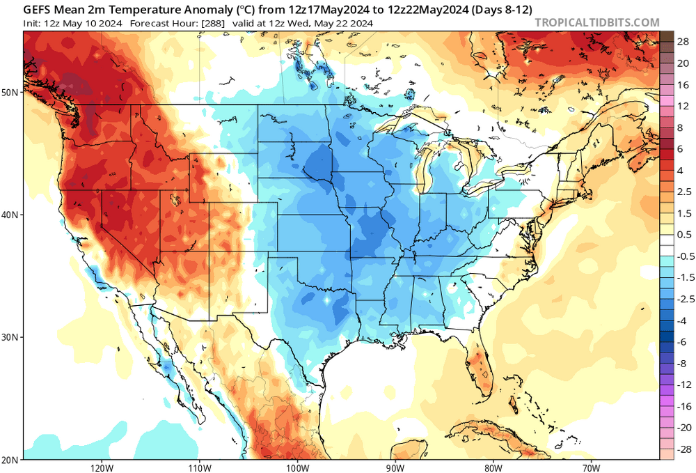
When the Watch was issued this morning, I flashed it in my newsletter with an advisory that the blend had diminished overnight from 1.02" down to .86" thru 00z 11-20. Who is correct at this hour, the models or the mets. at Sterling???? No contest.......... But 2 am has not arrived.............
-

May 2024 Discussion - Welcome to Severe Season!!!!
tamarack replied to weatherwiz's topic in New England
A few days checking out the buffet, then a week or so of casual dining (the current situation here) followed by a week plus of diving in teeth first - no wandering around looking for a soft spot, just eat and run. Sugar maple leaves about 3/4 grown, red oak halfway, ash and basswood lagging behind as always. -
Using central park as your argument... lmaooo
-

La Niña peak strength prediction poll
George001 replied to George001's topic in Weather Forecasting and Discussion
Some of the guidance has backed off a bit, but the latest obs show that rapid cooling is occurring in regions 1.2 and 3 already. The early development of this Niña could potentially indicate that the more aggressive guidance has the right idea. Weaker events don’t usually start developing until later. -
There's nothing globally that's happening that is different from the decadal trend, so I like the forecast. In 2020, I started realizing that we were "evening out" one year to another (Feb 2020 would be +pna so Feb 2021 would be -pna, etc.), and I do think we are "due" for hotter weather in the Spring/Summer, partially because of how much cooler it has been relative to the trend in recent years. if not this year, then future years.. March 2012 was super warm, then Summer 2012 broke the record for arctic ice melt, so maybe as that starts heavily progressing again we will go warmer?
- Today
-
https://www.yahoo.com/news/houston-recovery-mode-storm-kills-131840576.html
-
I fear the east wind next week… I hope it’s not more of the same with a 80 degree day sprinkled in
-
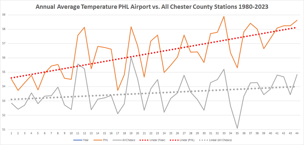
Yep sure looks like a similar warming trajectory from the UHI PHL Airport vs all of those Chester County NWS COOP and MADIS sites just since 1980....which of course only includes our current warming cycle of climate change
-
This was already addressed the east and west is not as critical as the elevation above sea level which we have already detailed in the above post with those splits. There are clearly and consistent with the old data more stations in the recently current data at the relatively lower elevations. Not at the higher elevations. We will of course be analyzing data that reviews the data individually at both the relative higher and lower elevation locales to account for any variables due to these elevations.
-
i prefer 55 and mist....
- 883 replies
-
- 3
-

-
- spring
- cool temps
- (and 3 more)
-
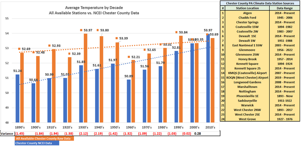
LOL!! "quality sites" meaning those that disagree with your NWS Climate sites including both PHL and ILG Heat Island impacted stations and of course add in those after the fact chilling adjustments to the past and warming tweaks to the current data. Quite the different look from the above for Chester County if we don't make warming adjustments to the actual current data. Regarding the sites in more detail yes there was as a % more lower elevation sites in the past....which likely skewed those results too warm...even though they were in fact the warmest decades. The good news is we now have a good balance and mix that as long as we keep breaking it out by elevation will clearly show the non-adjusted factual real world warming or cooling depending on the current climate change cycle.
-

2024 Mid-Atlantic Garden, Lawn, and Other Green Stuff Thread
IronTy replied to mattie g's topic in Mid Atlantic
Today's contribution! Things are getting a late start this year due to the crap weather. Sent from my Pixel 8 Pro using Tapatalk -
DC proper is the new Short Pump?
-
JB is already building hype for next winter. I'm predicting Sistene chapels and massive hymns from dec-mar.
-
It's about as lush and green as Scotland out there. Been the perfect amount of regular rains this spring.
-
so bad
-
I'm driving up to Annapolis to pick up a new motorcycle tomorrow morning, I'm sure heavy rain is a lock for the AM ride home.
-

May 2024 Discussion - Welcome to Severe Season!!!!
powderfreak replied to weatherwiz's topic in New England
Bedford. -
The weekend patterns have been yuck for sports. The younger Ms J was supposed to have a horse show all weekend. It was postponed for the safety of the horses and riders. They show in rain but not pouring rain that would slick up the footing.
-

May 2024 Discussion - Welcome to Severe Season!!!!
CoastalWx replied to weatherwiz's topic in New England
What town(s)?? -
May 2024 Discussion - Welcome to Severe Season!!!!
powderfreak replied to weatherwiz's topic in New England
Yeah we’ve had one 69F and 4 days of 70+ in the past 5. Really been a nice stretch in NNE over the top. Black flies were noted yesterday for the first time at the mountain, though not biting or really swarming. Seemed like drunk black flies waking up or something, just aimlessly floating around. They’ll sober up and get the munchies soon. -
May 2024 Discussion - Welcome to Severe Season!!!!
powderfreak replied to weatherwiz's topic in New England
Heading down to Albany this weekend, should be a bit better out that way. Moving my folks from ALB to SNH and my sister and her 3 kids are going from BGM to SNH too for my brother-in-laws job. Going to start spending more time down that way between CON and MHT. -
May 2024 Discussion - Welcome to Severe Season!!!!
tamarack replied to weatherwiz's topic in New England
Another low 70s day, 4th in the last 5 with 69 on the one miss. TD is well below midsummer swamp level, but high enough for considerable sweat while working up some firewood. (The fact that it was elm added to the sweat, though my having killed the tree 2 years ago actually made the cross-grain a bit weaker.) Fair amount of black flies out and about, and starting to get hungry. Maybe we'll miss the worst of the swarms as we're headed to SNJ for the last week of the month - oldest granddaughter graduates HS.