All Activity
- Past hour
-
I have not looked at MDT but I will do so and let's see how much and if they adjust after the fact
-

Central Pa. Spring 2024
TheClimateChanger replied to mahantango#1's topic in Upstate New York/Pennsylvania
They must be manipulating the raw data out of the MDT ASOS because almost every recent year has been record warm. -
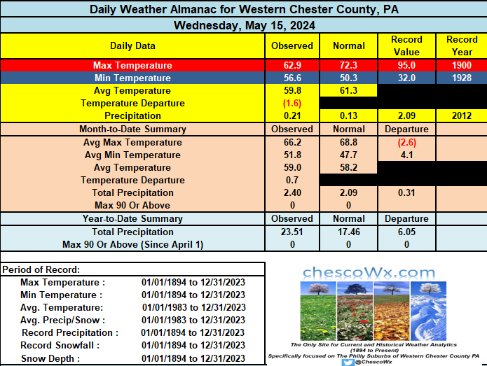
While not the sunniest of days, today and Friday should be dry and not too far from our normal high in the low 70's. We chill back down to below normal over the weekend with shower chances the highest on Saturday but dry again on Sunday. Chester County wide records for today: High 91 degrees at Phoenixville (1945) / Low 30 degrees at Coatesville 1SW (1956) / Rain 2.16" at Glenmoore (2012)
-
They speak in general terms of site movements, time of observation adjustments and equipment issues. The detail appears to not be applied at a station level they simply apply it to the county wide averages.
-

May 2024 Discussion - Welcome to Severe Season!!!!
Sn0waddict replied to weatherwiz's topic in New England
6 inches out on block island. -
Central Pa. Spring 2024
TheClimateChanger replied to mahantango#1's topic in Upstate New York/Pennsylvania
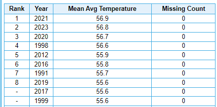
Through May 15, the mean temperature at Harrisburg International Airport (MDT) is currently 45.8F, good for 4th warmest YTD in the threaded records behind 2023, 1998 & 2012. Turning to the top 10 for the full year, 2021 is number one, followed by 2023 and 2020. To date, MDT is running 1.7F warmer than 2021, 1.3F warmer than 2020 and 0.8F cooler than 2023. Could make a run for warmest year on record this year (dating to 1889).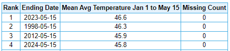
-

E PA/NJ/DE Spring 2024 OBS/Discussion
ChescoWx replied to Hurricane Agnes's topic in Philadelphia Region
While not the sunniest of days, today and Friday should be dry and not too far from our normal high in the low 70's. We chill back down to below normal over the weekend with shower chances the highest on Saturday but dry again on Sunday. Chester County wide records for today: High 91 degrees at Phoenixville (1945) / Low 30 degrees at Coatesville 1SW (1956) / Rain 2.16" at Glenmoore (2012)
-
I agree. I think there is definitely an above normal chance of a strong La Niña. That said, do I think it gets to the levels of 73-74 or 88-89? Probably not, since those 2 are the strongest Nina’s on record
-
There were a lot of forecasts about it being a hot and very dry summer. It's only May but we have had over 6 inches of rain the past 2 weeks and the next 10 days looks like more of the same.
-

May 2024 General Discussion
SchaumburgStormer replied to HillsdaleMIWeather's topic in Lakes/Ohio Valley
I got so used to the suddenly slam from upper 50's to upper 80's that I forgot what a nice extended spring feels like. Couldn't draw it up better by my definition, mid 70's for days on end with rain chances every other day or so. -
No one cares about his data that is more than likely poorly sited, lower quality, and not augmented regularly.
-
Even just a -1.5 ONI could be enough for the strongest Niña on record on a RONI basis (records back to 1950). The strongest RONI is -1.94 of OND 1973 followed closely by -1.93 of NDJ 1988-9. Keep in mind that the latest RONI (FMA 2024) is a record breaking 0.67 lower than ONI (+0.48 vs +1.15). Here’s the list of strong RONI based La Niña: -1.94 OND 1973 -1.93 NDJ 1988-9 -1.70 OND 2010 -1.67 DJF 1999-00 -1.65 NDJ 1998-9 -1.62 OND 1955 -1.58 DJF 2007-8 -1.52 OND 2020 (corrected) 1995-6 went down only to -0.94. https://www.cpc.ncep.noaa.gov/data/indices/RONI.ascii.txt
-
That’s cool and all, but you see, Chesco has spliced his 20 years of records in with 110 years of already existing NWS data, so it basically is NWS data.
-
NWS data is all that matters.
-

May 2024 Discussion - Welcome to Severe Season!!!!
kdxken replied to weatherwiz's topic in New England
-

E PA/NJ/DE Spring 2024 OBS/Discussion
LVblizzard replied to Hurricane Agnes's topic in Philadelphia Region
Another year, yet another very slow start to thunderstorm season. It’s the middle of May and I can recall just one, maybe two storms here in Allentown. Looks like nothing in the forecast for at least the next week either. I know our peak is usually around July and August but I don’t remember spring being this dead year after year. Glad I’ve started chasing in the plains for a week or two every year because spring has just been boring here. -
The ten-day would make next week appear to be relatively dry and warm. To quote Mills Lane, "I'll allow it."
-

Central Pa. Spring 2024
Itstrainingtime replied to mahantango#1's topic in Upstate New York/Pennsylvania
Sunny and 70. It's a beautiful day! -

May 2024 Discussion - Welcome to Severe Season!!!!
weatherwiz replied to weatherwiz's topic in New England
I'm trying to remember back a few days ago, but the GFS may have been onto the idea, just not as aggressive as the NAM. IIRC, the NAM was the more aggressive with the development of llvl circulations and were further north with them. The GFS was a bit weaker and south (which I think was similar to the Euro). You have to wonder if even 15-20 years ago would an event have performed as such, with the atmosphere holding so much more moisture now and all...these type of setups may be bound to produce more rain. We're looking at PWAT anomalies which are like +1.5SD right now. -
Again Charlie has an answer to his question "Why are they cooler?" His answer is that they are further N+W, higher elevation. Again let's go to the facts for the truth. According to the NWS Mount Holly CWA forecast zones - of the current 16 stations reporting 9 of them are in the Eastern Zone of Chester County and only 7 are in the Western Zone. So they are in fact NOT more located to the N and W. So now how does the elevation look at these stations? Well in fact 11 of them are at lower elevations below 465 feet ASL while only 5 are located at greater than 525 feet ASL. So there are actually more at lower than higher elevations. Facts over feelings as always!
-
So much for me bringing the heat back with me...
-

May 2024 Discussion - Welcome to Severe Season!!!!
Typhoon Tip replied to weatherwiz's topic in New England
It kinda 'suggests' that the GFS, with its apparent hypersensitivity in creating/emerging all these gnats and rogue perforations that undermine ridging ... yeah, it's probably too sensitive, but the physics 'sensing' this sort of oddities - this is one of those perforations. It's not completely useless in that sense. -

May 2024 Discussion - Welcome to Severe Season!!!!
SJonesWX replied to weatherwiz's topic in New England
wow, I'm surprised. up to around 3/4" here. needed it. -
I grew up in very sunny Mays which is what we had in the 90s. The climate models that said we would just get super baking hot in a straight line were wrong-- I have to say. It might be true in other parts of the world but definitely not here.
- 782 replies
-
- 2
-

-
- spring
- dry weather
- (and 3 more)
-
Yeah, this May has been terrible. Last year was great.
- 782 replies
-
- 1
-

-
- spring
- dry weather
- (and 3 more)