All Activity
- Past hour
-

Ice Ice Baby December 28-29 Storm Discussion
WxWatcher007 replied to Baroclinic Zone's topic in New England
Meanwhile in Michigan. Would people pass on a blizzard if it did this? -
41 and cloudy. Precipitation done and only two hours of daylight left. Looks like this snow pack is going to be around well into the New year.
-
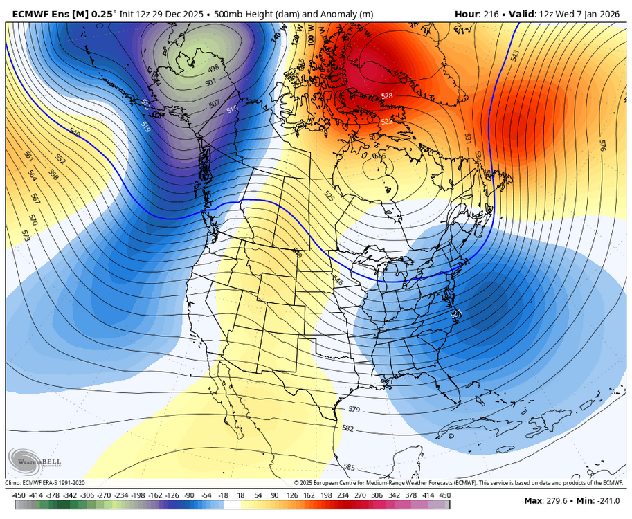
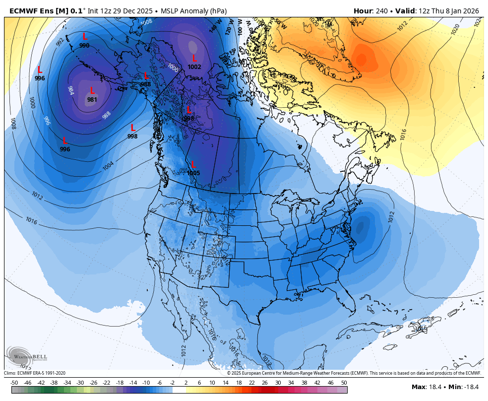
12z EPS has a pretty good signal for a coastal on the 7th/8th on the MSLP anomaly maps. Waiting for the precip/other maps to roll in.

-

E PA/NJ/DE Winter 2025-26 Obs/Discussion
The Iceman replied to LVblizzard's topic in Philadelphia Region
Hit 53 here, wind moving in now. Weve been doing wind really good this winter. -
I use freeimage.host. Just add the image you want, once it's uploaded, click on it, then open the image only in a new tab, copy that link and paste it here.
-
Pittsburgh gusted to 61
-
I was coming to say that the Euro/GEM/EuroAi all have some wintery threats loaded. No monsters but active potential once the Pacific locks in. The GFS, which could be right, is on an island. It's verified horribly here and in the Pac NW over the last 90 days. Way too cold there, way too warm here.
-

Ice Ice Baby December 28-29 Storm Discussion
dryslot replied to Baroclinic Zone's topic in New England
RN, 33/32°F, The pack lives on.
-
HGR and MRB gusting over 50 mph. Keedysville mesonet gusted to 48 mph. Bittinger mesonet gusted to 51 mph. Clarksville mesonet gusted to 46 mph.
-
I'm looking for 1" on Thursday, can you help a brother out.
-
Winter Storm Watch posted by LWX and Pitt for the mountains NYE into NYD for 6”+ Western Garrett-Eastern Garrett-Western Grant-Western Pendleton- 144 PM EST Mon Dec 29 2025 ...WINTER WEATHER ADVISORY REMAINS IN EFFECT UNTIL 10 AM EST TUESDAY... ...WINTER STORM WATCH IN EFFECT FROM WEDNESDAY AFTERNOON THROUGH THURSDAY MORNING... * WHAT...Snow expected. Total snow accumulations of 2 to 5 inches with localized amounts around 6 inches possible along the western facing slopes above 3,000 feet. West winds will gust around 55 to 65 mph. For the Winter Storm Watch, heavy snow possible. Total snow accumulations 6 inches or more are possible. Winds could gust as high as 50 mph. * WHERE...In Maryland, Eastern Garrett and Western Garrett Counties. In West Virginia, Western Grant and Western Pendleton Counties. * WHEN...For the Winter Weather Advisory, until 10 AM EST Tuesday. For the Winter Storm Watch, from Wednesday afternoon through Thursday morning.
-

Ice Ice Baby December 28-29 Storm Discussion
metagraphica replied to Baroclinic Zone's topic in New England
45/44 and this rain ain't gonna get it done. The pack is shrinking but I don't think it's going to disappear. Should still have some left over once this is all said and done. -
I definitely think we’ll have to endure a brief mild period while that +PNA builds. Gotta hope in the immediate long range that our -NAO bullies the pattern a bit. I think it could but the Ohio Valley to the Northeast are certainly favored at the moment.
-
You rang.
-

Ice Ice Baby December 28-29 Storm Discussion
ineedsnow replied to Baroclinic Zone's topic in New England
High wind warning here now . Hopefully get some damage -

January 2026 regional war/obs/disco thread
SnowGoose69 replied to Baroclinic Zone's topic in New England
Safe to say one of the GEFS or EPS/GEPS will end up badly wrong on their PNA forecasts -

Winter 2025-26 Medium/Long Range Discussion
hawkeye_wx replied to michsnowfreak's topic in Lakes/Ohio Valley
Models continue to be very boring and dry through mid January for much of the middle of the country. -
Kissed 50F after a low of 32F. Trash bins weighed down with leftover Christmas junk, will they withstand the wind??
-
Warms up before another cutter around the 11th was hoping that would stay south this run. Still time to watch it but lots to iron out.
-
I got a picture of my kids in my wallet. Let's ease up a bit huh?
-

Ice Ice Baby December 28-29 Storm Discussion
Roger Smith replied to Baroclinic Zone's topic in New England
A century ago the phrase "silver thaw" was used to describe the conditions being reported in n NE today. I am not sure when that went out of the vocabulary but it was even inserted into official documents of weather data in the 1920s and earlier. -
Slushy patches left here in Washington Square Park. Probably gone by the end of today.
-

Central PA Winter 25/26 Discussion and Obs
WmsptWx replied to MAG5035's topic in Upstate New York/Pennsylvania
I don't think the temperature ever got to 40°F here today. Winds are definitely whipping. -

January 2026 Medium/Long Range Discussion
NorthArlington101 replied to snowfan's topic in Mid Atlantic
Can sorta see two distinct threat windows if you squint. Regardless, pretty active. I'll take the GEFS control. 30" in one storm seems ok. 42" in 2 weeks -

January 2026 regional war/obs/disco thread
brooklynwx99 replied to Baroclinic Zone's topic in New England
all three models and their ensembles have the highly anomalous block along with the Pacific trough briefly pumping the PNA... the 6-8th holds legit potential for a large coastal storm given all of the synoptic components involved