All Activity
- Past hour
-

Jan 24-26 Weekend Snow and Sleetfest Model Thread Part Tres
WxMan1 replied to H2O's topic in Mid Atlantic
Typically the degree of the warm air (MaxT aloft) will be proportional to the depth. In other words, the highest the MaxT aloft, the deeper the warm or >0C air. In many studies I've seen though, no matter how deep or shallow the warm air is, when you hit 3C or 37F, you're completely melting the hydrometeor. Once that happens, there's no going back to sleet or anything "pellety" unless the air somewhere within the subfreezing layer can get down to -13C/8F or lower. Unless that happens, the rain drop does not refreeze. When we see sleet, it's typically associated with an elevated warm layer temp between 0.5C and just below 3.0C. When it's closer to 0.5C, it's probably more of a sleety & rimed snow mix. When the MaxT aloft is closer to 2.5C, it's more like a sleet ball, with little if any evidence of a mangled snowflake. -
 I'm starting to have a love-hate relationship with this storm.
 -

January 24-26: Miracle or Mirage JV/Banter Thread!
Maestrobjwa replied to SnowenOutThere's topic in Mid Atlantic
Doesn't count. Sleet is not snow and that's a troll way to get to a warning...I just want 6+" of snow. Been 10 years. It should not be this hard -
It comes down to liability. People are afraid to make a call and be wrong. Again, from a Risk Management point of view, I am actually sounding an alarm and have been to those I know and advise. The truth is we dont KNOW what will happen. However, there is a high probability of a significant ice storm. There is a medium to high possibility of a crippling ice storm. There is a moderate possibility of a catastrophic ice storm. From a Risk Management perspective, this is where you plan for severe disruption and pray you are wrong. But, if there was any WINTER storm where I would pull out the stops, its this one.
-
 are they only discontinuing the regular nam or also nam 3k?
 -
It sucks bad 1.5" we dry slot it away
-
But for the entire state, we’re living’ on a prayer, one way or another. Whoa ohhh… Side note: Jeff, could the colder trend lead to a longer period of sleet before the freezing rain?
-
New York City: 6” Boston: 14” Philadelphia: 5” Washington DC: 4” Hartford: 13” Albany: 12” Me: 8”
-

“Cory’s in LA! Let’s MECS!” Jan. 24-26 Disco
DavisStraight replied to TheSnowman's topic in New England
I just got a dusting too. -

Jan 24-26 Weekend Snow and Sleetfest Model Thread Part Tres
SomeguyfromTakomaPark replied to H2O's topic in Mid Atlantic
2.5 inches of sleet on top of 4.5 inches of snow would be wild. The NAM has been right, but it’s also fell on its face in embarrassing fashion close up to events as well so of course consider it but I wouldn’t assume 100 percent it is correct. Just have to keep it in mind as a possibility. -
My only saving grace around wnc is that most of these lines were redone and repoled after helene. .
-

Central PA Winter 25/26 Discussion and Obs
Lucy Pull replied to MAG5035's topic in Upstate New York/Pennsylvania
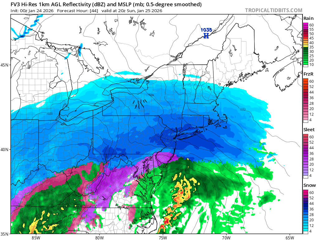
FV3 still much colder than NAM. Sleet line further north than prior run though. -
3k is great here Monday. CF already back down here.
-

Possible Record Breaking Cold + Snow Sunday 1/25 - Tuesday 1/27
EastonSN+ replied to TriPol's topic in New York City Metro
I believe central park had 7.5 inches before the thundersleet. Up here in CT had 9.5 before the thunder sleet -
Winter cancelled/uncancelled banter 25/26
WeatherGeek2025 replied to Rjay's topic in New York City Metro
i know this will probably bust out too high, i tried and i posted this wednesday. well i can redo one tomorrow lol -

Possible Record Breaking Cold + Snow Sunday 1/25 - Tuesday 1/27
cleetussnow replied to TriPol's topic in New York City Metro
Have to use models judiciously. These storms come north - always. The models are late to the game - always. And there will be a dry slot. -

Possible Record Breaking Cold + Snow Sunday 1/25 - Tuesday 1/27
MJO812 replied to TriPol's topic in New York City Metro
Fv3 3k Nam is also colder.thumb.png.4c9a81ebeb3bccc1dd4868f029be423e.png)
-

Pittsburgh/Western PA WINTER ‘25/‘26
Burghblizz replied to Burghblizz's topic in Upstate New York/Pennsylvania
Tongue closed in on 3k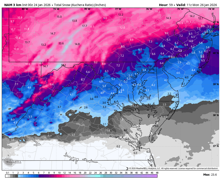
-
hour by hour it had -45, but if -48 happened on a non-hourly observation, I'd believe it
-

January 25-26 Winter Storm Potential
Ralph Wiggum replied to Ralph Wiggum's topic in Philadelphia Region
If it makes you feel better, here's the most biased cold model the fv3, often wrong, seldom right. A big hit!
-

Pittsburgh/Western PA WINTER ‘25/‘26
colonel717 replied to Burghblizz's topic in Upstate New York/Pennsylvania
Its getting to radar watching time. -

Jan 24-26 Weekend Snow and Sleetfest Model Thread Part Tres
Chris78 replied to H2O's topic in Mid Atlantic
I hope the hell it's right. Change over is 4pm or a little after at the M/D line. Nam changeover is 6 hours or so earlier? -

Jan 24-26 Weekend Snow and Sleetfest Model Thread Part Tres
Buddy1987 replied to H2O's topic in Mid Atlantic
Hands down one of the most impressive sleet accumulation forecasts I’ve ever personally seen. 5.7” is pretty awesome. I’ve fully accepted the sleet-mageddon and I’m excited now. -

Jan 24-26 Weekend Snow and Sleetfest Model Thread Part Tres
TSSN+ replied to H2O's topic in Mid Atlantic
The snow and sleet combo would be a warning level "snow" -
Jan 24-26 Weekend Snow and Sleetfest Model Thread Part Tres
Maestrobjwa replied to H2O's topic in Mid Atlantic
My bar for this storm. I hope that's still possible, man. But if the NAM is right even the low end might be in trouble (that run gives Baltimore 5.2")


.png.ee8e0bfb5b897f161bf1a6307afdce37.png)