All Activity
- Past hour
-

Extreme Cold, Snow & Sleet: SECS 1/25 - 1/26
EasternLI replied to TriPol's topic in New York City Metro
Not saying I trust it. Just saying I'd take it lol -

Extreme Cold, Snow & Sleet: SECS 1/25 - 1/26
Stormlover74 replied to TriPol's topic in New York City Metro
I still wouldn't trust it. Seems wonky since yesterday -

Extreme Cold, Snow & Sleet: SECS 1/25 - 1/26
allgame830 replied to TriPol's topic in New York City Metro
Yeah we are all pretty sure you said that about the NAM like 5 times yesterday! -
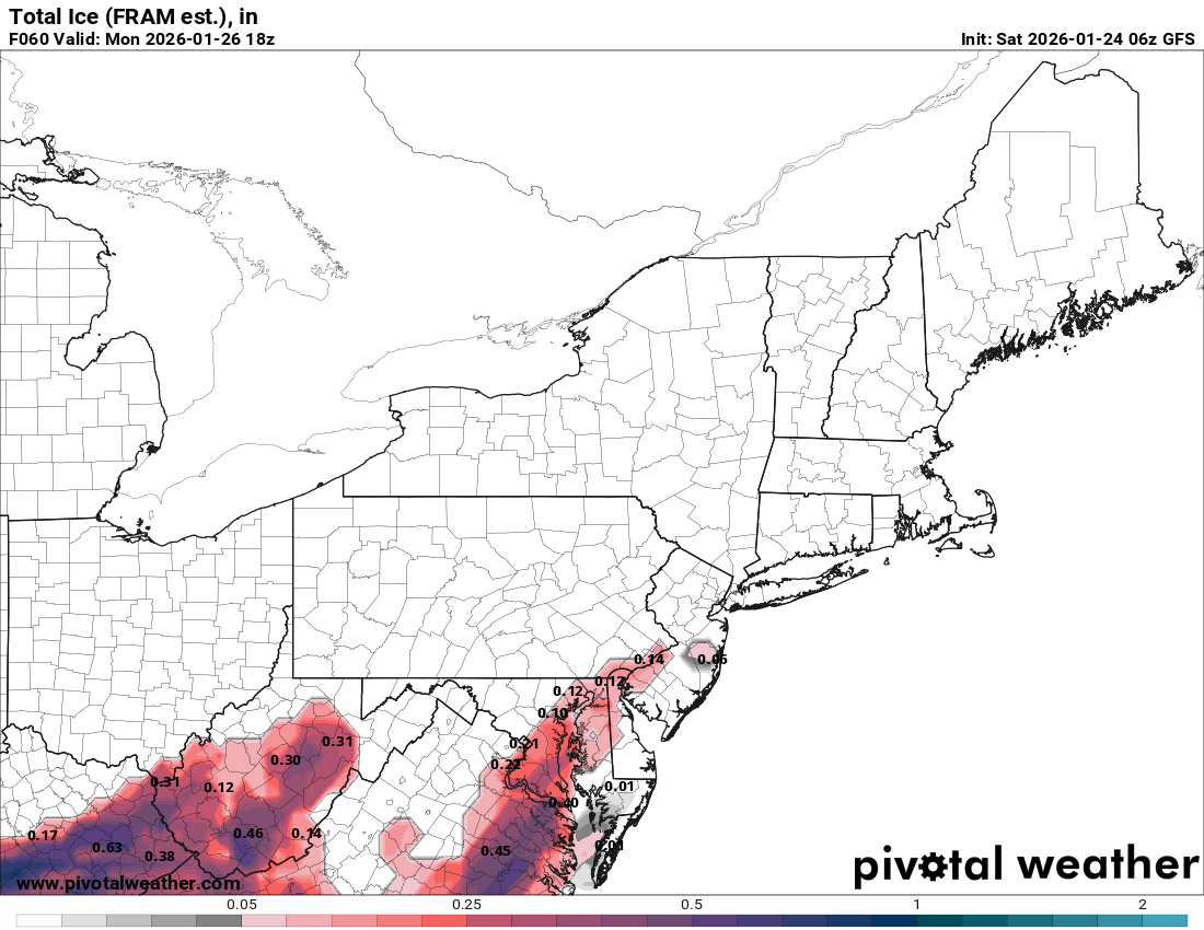
The NWS actually mentions both scenarios. In other words they have no idea lol Intense isentropic lift atop the cold dome combined with anomalously moist air (PWATs of about 1"...in ~the 90th percentile of daily climatology)...followed by strong/focused ascent along a frontal boundary Sunday afternoon/evening will result in impressive storm total liquid equivalent precip...with 2-3 inches forecast across the mountains of southwest NC, SC, and northeast GA, and generally 1.5-2" elsewhere. Strong warm advection aloft will establish a warm nose that will eventually (a) support a transition from sleet to freezing rain from SW=>NE and ( allow for the valleys of far southwest NC...which will only be weakly affected by CAD...to warm above freezing. The first main forecast challenge is timing the transition to freezing rain. Forecast soundings become quite warm (+5C or more) aloft rather quickly tonight, suggesting a quick transition to FZRA. However, the cold layer at the surface is cold and deep enough to perhaps allow for some refreezing of hydrometeors before they hit the surface. However, this is far from a given...and it lends modest confidence to our ice/sleet accum forecast going forward. Nevertheless, most of the precip is expected to fall as freezing rain such that much of the CWA is expected to see storm total ice accums of 0.5-0.75." An exception on the higher end (0.75-1.0" with locally higher amounts) is forecast along the Blue Ridge escarpment...where the greatest alignment of persistent cold air and higher liquid equivalent is forecast. These amounts are expected to extend across the foothills of SC into the Greenville metro area as well. Widespread downed trees/lines and power outages are expected to be most concentrated in this area. On the lower end, a gradual transition to rain is expected along the southern and western periphery of the CWA during Sunday afternoon due to the synoptic pattern quickly becoming unfavorable for maintenance of cold air damming. This will occur as the upper flow pattern becomes phased...with a long wave trough being carved out over the eastern Conus and an upper ridge quickly building off the East Coast, resulting in cessation of confluent flow and allowing the weakening parent high to move far north into Quebec and become detached from the inverted ridge CAD ridge. The wind field responding to a developing coastal low will provide an additional erosion mechanism. As such, ice totals across the SC Lakelands and vicinity are expected to be in the 0.25-0.5" range, while the valleys beneath the Smokies may struggle to reach 0.25." In summation: forecast ice totals could be too low by 0.1-0.25" if the transition from sleet->freezing rain occurs significantly earlier than currently anticipated. Forecast totals could be too high along and south of the I-85 corridor if CAD erosion is more aggressive than currently forecast. Finally, locally excessive rainfall will be possible across mountainous areas where the transition to rain occurs Sunday afternoon...with the strong frontal band (where an isolated elevated thunderstorm cannot be ruled out) likely providing the tipping point to some minor runoff issues developing late afternoon/evening. .
-
 Morgan county has almost a 10 degree difference from NW -> SE:
 -

Jan 24-26 Weekend Snow and Sleetfest Model Thread Part Tres
Buddy1987 replied to H2O's topic in Mid Atlantic
Am I radar hallucinating already?! The band of snow developing off the Jackson KY radar pushing into VA looks legit. -
 -2.2 Sent from my SM-S166V using Tapatalk
 -
Extreme Cold, Snow & Sleet: SECS 1/25 - 1/26
EasternLI replied to TriPol's topic in New York City Metro
I would sign right now for the 6z Ukie -
Extreme Cold, Snow & Sleet: SECS 1/25 - 1/26
Stormlover74 replied to TriPol's topic in New York City Metro
What about the hrdps? Its not terribly different than the nam but seems thumpier -

Extreme Cold, Snow & Sleet: SECS 1/25 - 1/26
wthrmn654 replied to TriPol's topic in New York City Metro
Wtf -
“Cory’s in LA! Let’s MECS!” Jan. 24-26 Disco
Prismshine Productions replied to TheSnowman's topic in New England
Don't give me false hope like that Sent from my SM-S166V using Tapatalk -
Baseline for later obs: Not much difference between East TN and CAD areas this AM
-

Jan 24-26 Weekend Snow and Sleetfest Model Thread Part Tres
mitchnick replied to H2O's topic in Mid Atlantic
Euro snow depth as of 7am Monday. Mix or not, that's still a lot of snow remaining on the ground after the storm..thumb.png.1e0fe7bac5b327d1410648213499b4e7.png)
-

January 24-26: Miracle or Mirage JV/Banter Thread!
RevWarReenactor replied to SnowenOutThere's topic in Mid Atlantic
Its not any better with delmarva. There was outrage last year, people ain't seen nothing yet. Im betting bills are going to easily be over $1000 a month for many. Some days its so bad, its actually cheaper to go stay in a hotel than it is to heat your house. -

Central PA Winter 25/26 Discussion and Obs
mahantango#1 replied to MAG5035's topic in Upstate New York/Pennsylvania
US National Weather Service State College PA 24 JAN 2026 @ 6:45 AM EST: Arctic air has returned to the region and will set the stage for frozen precipitation to fall with the approaching storm. -
Looks like some blowing and drifting in the cards Sunday Snow likely, mainly after 5pm. Mostly cloudy, with a high near 11. Wind chill values as low as -6. Calm wind. Chance of precipitation is 60%. New snow accumulation of less than one inch possible. Sunday Night Snow. The snow could be heavy at times. Low around 4. Wind chill values as low as -8. Light northeast wind increasing to 5 to 10 mph in the evening. Winds could gust as high as 20 mph. Chance of precipitation is 100%. New snow accumulation of 9 to 13 inches possible. Monday Snow. High near 15. North wind 10 to 15 mph, with gusts as high as 25 mph. Chance of precipitation is 100%. New snow accumulation of 3 to 7 inches possible.
-
HRRR really showing very specific areas of downsloping in NE TN this afternoon:
-
1 for the low at Pen Mar Park, up to 2 now.
-
 Sleet and ZR mix here. 28 degrees.
 -
Current temp is 26 degrees.
-

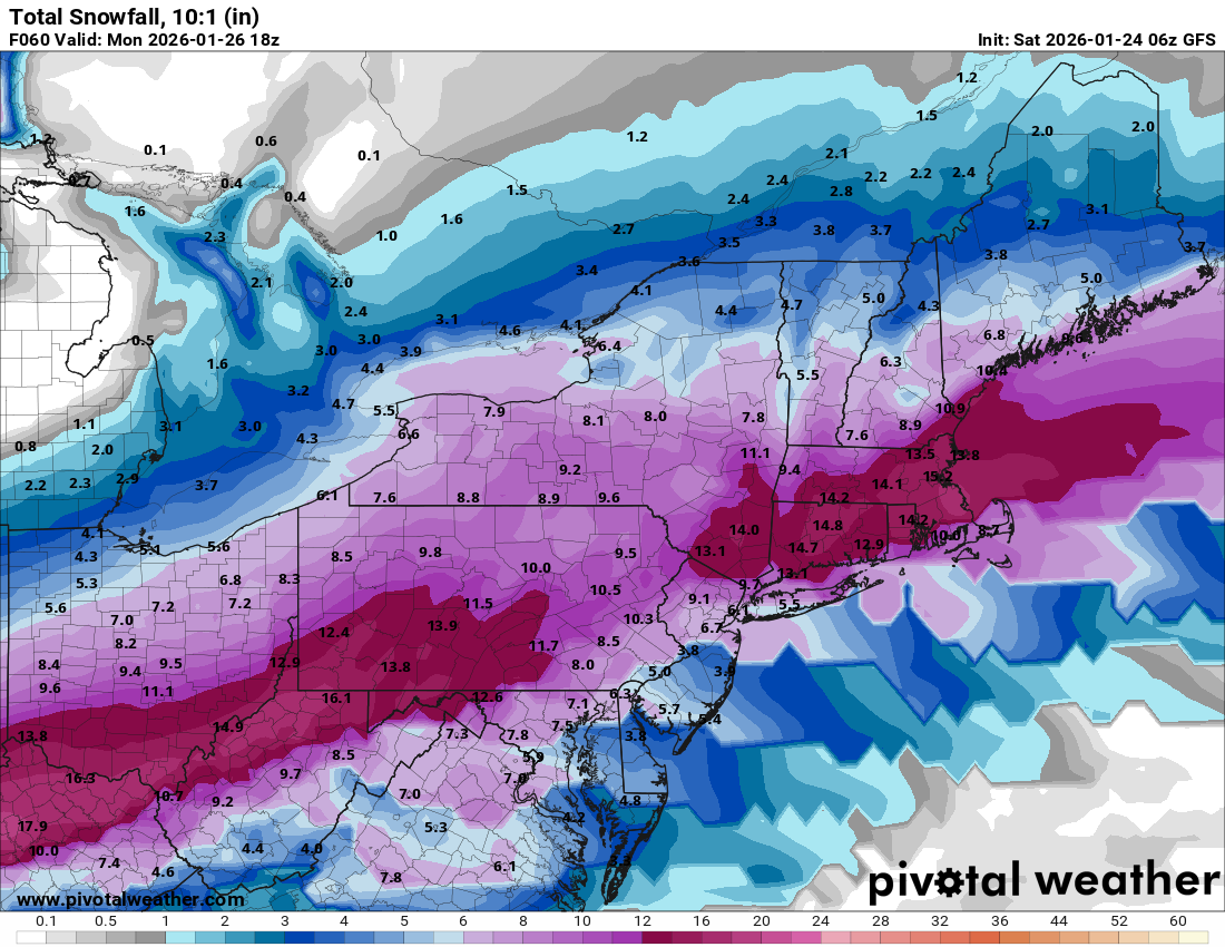
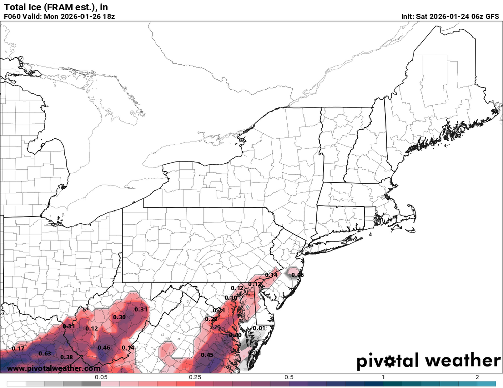
January 25-26 Winter Storm Potential
Hurricane Agnes replied to Ralph Wiggum's topic in Philadelphia Region
The GFS 6z just for completeness although we are obviously in the mesos/short term ranges.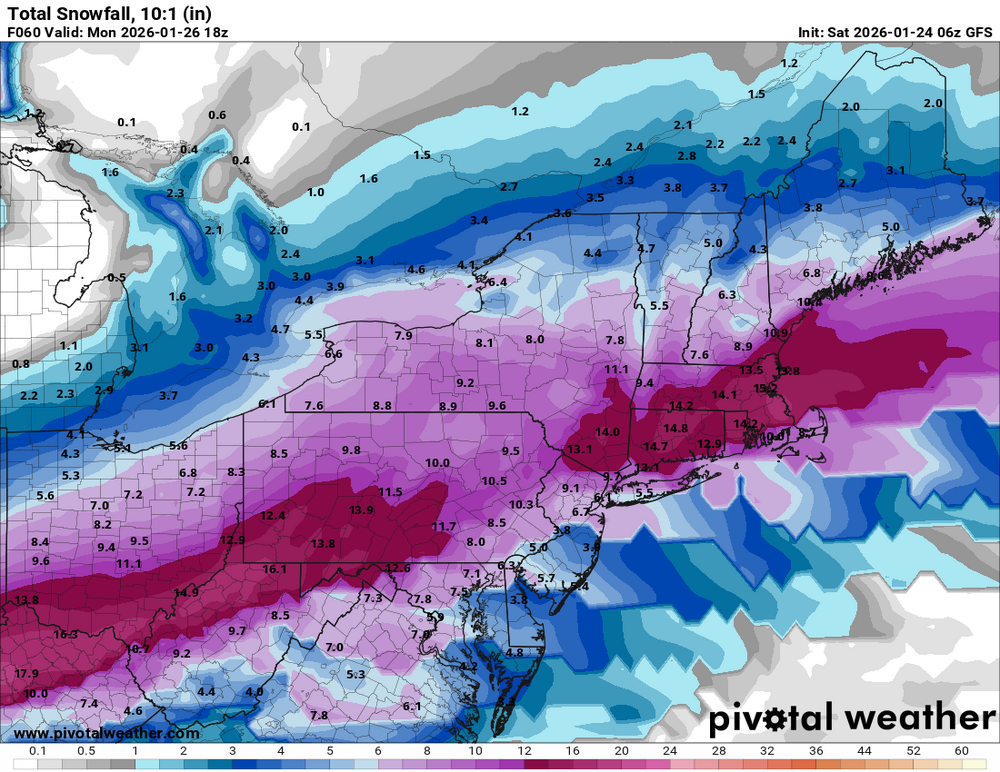
-
-
Moisture streaming in way ahead of the models currently.
-

January 24-26: Miracle or Mirage OBS Thread!
MN Transplant replied to Jebman's topic in Mid Atlantic
6.8 for the low. That would be my min for a bunch of winters. Probably will beat that this week. -
And there's another one coming if this guy is right https://www.severe-weather.eu/global-weather/polar-vortex-collapse-stratospheric-warming-february-2026-cold-united-states-canada-europe-fa/


.png.11d18c89161cae1984945b58af659543.png)