All Activity
- Past hour
-
Yea he hates the Knicks.
-
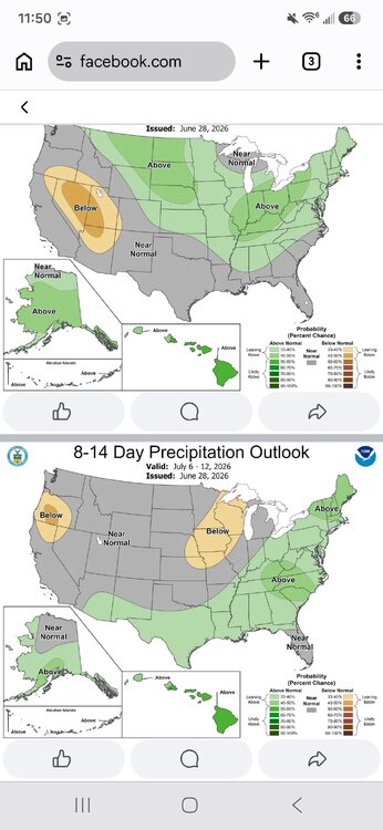
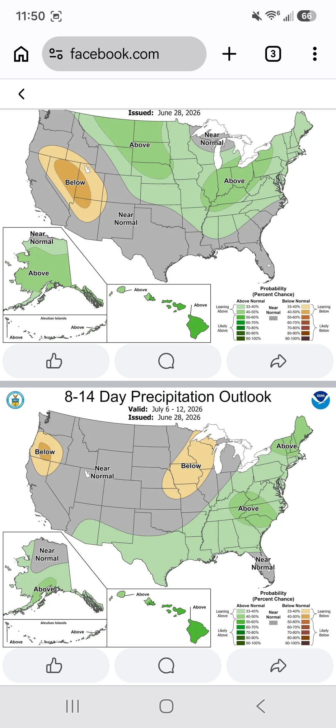
Short term forecast was mainly cloudy this aft, I know not what the pops % were but it was pretty low. Gets dark at noon, find light to mod rain coming fast outta nowhere. This is the 2nd worst short term peg this year. The aft is cooked. My 7 day is changing wildly run to run so any precip is a pure guess.
-
You mean die, not suffer.
-
So if we hit it twice, does this mean you will watch it 4 times?
-

2026-2027 Super El Nino
snowman19 replied to Stormchaserchuck1's topic in Weather Forecasting and Discussion
One thing I’m very, very confident in as far as winter, is a much warmer than normal to “torch” December this year because of what myself, @GaWx and you already discussed….the very strong correlation over the last 46 years (since 1980) of +QBO/El Nino (regardless of strength) Decembers being a slam dunk signal for warmth…literally 6 out of the last 6 were warm…. -
-
DPs over IL/IN/MI 75 to 80 55-60 locally. That air mass out there is heading this way. I don't know how exactly the that air mass entangles with the Lakes and then tumbles over terrain for us... but I could see there being some convection on the leading rim of that as it nears.
-
Apparently the ole temp sensor in the backyard station needs some work. It’s warm, but 90/81/108 at 10:55am seems a touch extreme
-

Occasional Thoughts on Climate Change
donsutherland1 replied to donsutherland1's topic in Climate Change
The latest estimates I have seen is 2.19C-2.26C (3.9F-4.1F): European land temperatures have increased even faster over the same period by 2.19 to 2.26°C, depending on the dataset used. https://www.eea.europa.eu/en/analysis/indicators/global-and-european-temperatures -
-
Lakeshore Keepers is a non-profit organization that maintains five lighthouses along the West Michigan shoreline. We have recently installed live-feed cameras either in the lantern rooms or just outside to be able to give better access to our lights. These cameras can be found here! Lighthouses include: White River Light Station (Muskegon County), Little Sable Point (Oceana County), Ludington North Breakwater (Mason County), Big Sable Point (Mason County), and Manistee North Pier (Manistee County)
-
I don't know if I would necessarily bet against it, however, I would put forth some caution into the extent of what some of the forecasts are in terms of its strength. I think its just way too premature to start tooting around x,y,z are happening because we have a super-strong that is developing. I still don't necessarily see how a lot of comparisons can be drawn to how the atmosphere is responding to something developing, particularly when it comes to the ocean. There is quite a time lag between ocean-atmosphere response. It's not like the atmosphere is going full EL Nino mode because the ocean is warming...there will be some time before that warming in the Pacific has a full-fledged impact on the atmosphere. For example, most EL Nino's, particularly stronger ones will tend to peak during the Fall at some point and begin to weaken moving through winter, but its not until the winter months in which you see a much stronger correlation to the impacts of EL Nino.
-
Update: 22 inches as of 9:00 local time today at Darkhorse Lake. I bet if this was July it could be a state record for the month.
-
Usually the Tuesday before Labor Day. So last yr 8/26. We also don't do the week off in Feb.
-
Correct
-
Absolutely, Don. It still would have been another historic heatwave even without AGW but not near as historic as it got due to the added effects from AGW. A larger portion of this extreme heat was very likely due to the pattern, itself, as opposed to AGW, itself. But AGW means a higher baseline as your quote said. The global baseline average has warmed ~2.5F since the late 1800s and not far from that even since just the mid-20th century if I’m not mistaken with the Arctic significantly higher and the tropics lower. How much do you figure the W Europe climate baseline has warmed?
-
and it's so small you're in Bridgeport or Stamford before you need to stop
-
Hey now, don't act like you don't know the type of posts I make.
-
Would you bet against it becoming established??
-
some may have a very dry week, too. Stein a possibility
-
When do you start
-
Lol... I love it John... Spot on!
-
The last time we hit 100 in this area was 38 years ago on August 18, 1988. I recorded 102 on that day as I was managing a VDOT paving crew. Try that when the pavement is close to 200 out of the plant.. It will melt the soles on your shoes.
-
2026-2027 Super El Nino
snowman19 replied to Stormchaserchuck1's topic in Weather Forecasting and Discussion
I absolutely believe that we break the 1982-83 all time RONI record and also the traditional ONI record. This thing is a monster. I fully expect the new model runs for July to get stronger with the peak -
In fact, El Nino summers tend to be cooler ... ? in 2023, some form of Nino was forecast to onset that summer, the whole planet jumped a half click C ( as poorly recognized geological event) before said El Nino arrived. Yet to this day, I still hear the blame. Wrong epistemic/chronological direction. I think though that people toss around conjecture as though it were more substantive than it is. Some are doing it because that's just how people are in groups. Others because they're divisive. Welcome to the human species. LOL


.thumb.gif.f92b16c631a1d15d405ed77b33f0710d.gif)


