All Activity
- Past hour
-
18z NAM shifts north for Monday
-

December 2025 regional war/obs/disco thread
weathafella replied to Torch Tiger's topic in New England
It was a nice snow burst whitening the ground earlier but now a memory. -

December 2025 regional war/obs/disco thread
butterfish55 replied to Torch Tiger's topic in New England
Nope, no joke. 0.0.....not even a flake (that I'm aware of). It's been quite a winter so far!!! -

December 2025 Short/Medium Range Forecast Thread
Carvers Gap replied to John1122's topic in Tennessee Valley
And a great question I might add. A great question is always better than a great answer....The more I think about it, the more I think it is because they have more snow cover right now. The trough is just a tick too far to the East right now as well. -
I definitely get that. I know a lot haven't been as fortunate as some of us in the mountains. Just waiting and watching.
-

Dec 6-7th (It's not a clipper) Clipper
cyclone77 replied to Chicago Storm's topic in Lakes/Ohio Valley
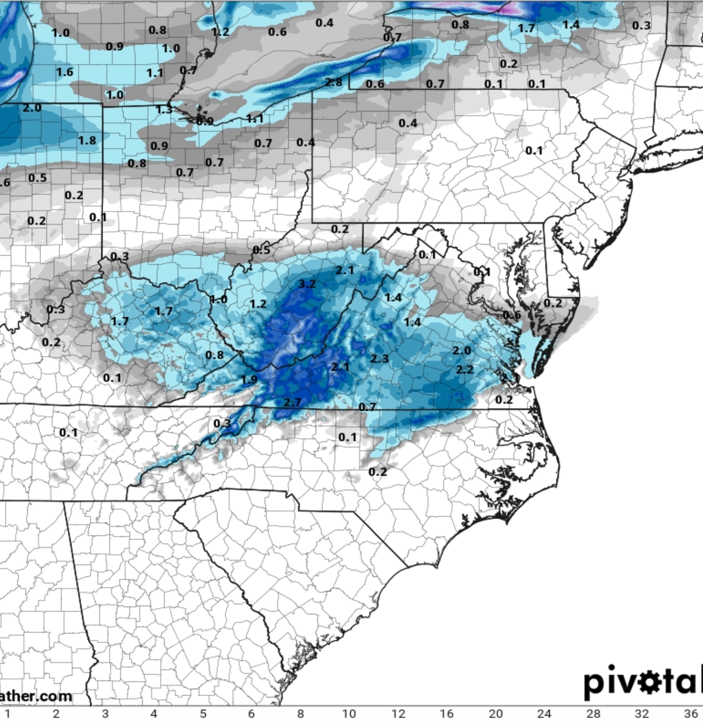
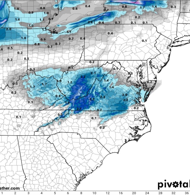
Our county as well. Point has 4.8" here, but some 6" amounts in the north part of the county. Models generally average 0.25-0.35" here. Looking like a solid 3"er with maybe a bit more if ratios play ball. -
The trough just wants to set up too far east the last few years. We need a 50/50 low
-
GEFS moved the trough west at 12z, right where we’d need it. Gotta get the euro ensembles on board though.
-

Dec 6-7th (It's not a clipper) Clipper
hawkeye_wx replied to Chicago Storm's topic in Lakes/Ohio Valley
DVN just upgraded my area to a winter storm warning and 5-7". I'm not expecting 7, but 5 would be nice. -
still targeting a mid January full leaf drop. The Oaks laugh at single-digit temperatures. The tops are mostly gone now. .
-

Dec 6-7th (It's not a clipper) Clipper
frostfern replied to Chicago Storm's topic in Lakes/Ohio Valley
I didn’t get out of bed in time to measure the official 9” total IMBY with that last storm. It was already down to 7” by the following afternoon. It’s around 5.5” now but high water content with a layer of freezing drizzle and dense sloppy on top. -
Hopefully that trend continues because there is potential there.
-
Almost a carbon copy of yesterday
-
Nice to see more ridging build out west in time. Maybe we can get one of these shortwaves to dig and deliver.
-
December 2025 Short/Medium Range Forecast Thread
Carvers Gap replied to John1122's topic in Tennessee Valley
Here is the average(lows and highs) for December through the 4th. I will go back up and post the map(with the reference years above...give me a sec to edit that one)... 1985, 2000, 2010, and 2024(almost the same start) are very similar or colder to 2025. But that is about it. -
Not with the upcoming pattern coming up. It should amplify more as we move into December.
-
It is honestly obscene. Was in a mall parking lot last night and i t was LOADED with rock salt. Almost could not see pavement though it.
-
.thumb.png.4150b06c63a21f61052e47a612bf1818.png)
December 2025 regional war/obs/disco thread
HIPPYVALLEY replied to Torch Tiger's topic in New England
I thought T-Blizz was joking about that. It’s bright blue skies in Greenfield right now. -
December 2025 Short/Medium Range Forecast Thread
Carvers Gap replied to John1122's topic in Tennessee Valley
Since 1980, the only month I can find w/ a faster(low max temp) start is 1985. Here is the Dec 1-4 data for 2025. These are the max temp departures. As Boone noted, overnight departures are not as strong. I have to think that is due to a lot of fog and cloud cover. I'll update w/ more recent numbers when this updates again. ***updated w/ reference maps of max AND low temp compositees*** -
One benefit to living in one of the worst snowfall areas in the region is that I was able to test my new bike (Trek FX2). Needed something different for pavement. Chilly out, but not that cold.
-
Let’s do it
-
I don't understand why this is the new trend. We got 1 inch of snow on Tuesday and the roads look like the middle of February after a blizzard.
-
Long Range HRRR for Monday
-

December 2025 regional war/obs/disco thread
moneypitmike replied to Torch Tiger's topic in New England
Those winds will put the 4x more I needed to pay for property insurance at the new Pit to the test. -
We are so close, it’s easy to see. Right now, we’re getting the red track with these shortwaves, which continues to favor a lack of digging and marginal weak events into the mid-Atlantic. Nudge that trough west so it’s centered over the lakes and we’ll be ready for takeoff. It wouldn’t take much to trend that direction - it’s really a small tweak at range. Pumping that ridge out west would be helpful too but we can’t have everything. .