All Activity
- Past hour
-
 Mr Senior changed their profile photo
 -
I would prefer it start Raining Blood
-
still holding at 100 at 6 pm. amazing.
-
 How do scientists explicitly account for urban heat when measuring Earth's global temperature to ensure that local heat islands do not skew data on global climate trends?
 -
 CAMs have been pretty bad with this stuff. But it's always been their biggest struggle. Remnant MCV-type initiation.
 -
Mby highs: 7/1 - 100 7/2 - 101
-

Central PA Summer 2026 Discussion/Obs Thread
Eskimo Joe replied to Voyager's topic in Upstate New York/Pennsylvania
Same. No way I'm fishing in this heat. -
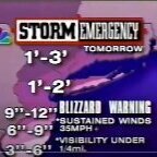
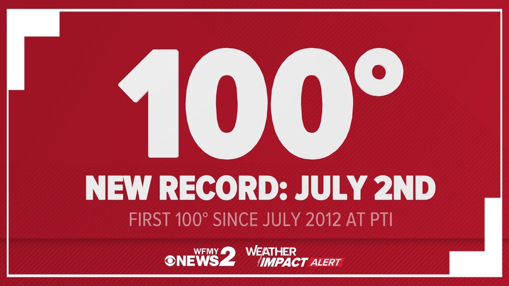
A short but severe heatwave will continue to scorch the region into the start of the weekend. Through 5 pm, highs included: Albany: 95° Allentown: 101° Atlantic City: 103° (old record: 100°, 1966) Baltimore: 101° Bangor: 93° (tied record set in 1941) Boston: 101° (old record: 98°, 1963) Bridgeport: 98° Burlington: 96° Caribou: 91° (tied record set in 2014) Concord: 97° Harrisburg: 102° Hartford: 100° (old record: 99°, 1966) Islip: 96° Manchester: 97° (old record: 95°, 1968) New Brunswick: 104° New York City-Central Park: 100° (tied record set in 1966) New York City-JFK Airport: 102° (old record: 101°, 1966) New York City-LaGuardia Airport: 104° (old record: 101°, 2016) Newark: 104° (old record: 103°, 1901) Philadelphia: 103° (tied record set in 1901) Portland: 96° Poughkeepsie: 103° (old record: 97°, 1966) Providence: 99° (old record: 98°, 1941) Raleigh: 98° Reading: 102° (tied record set in 1966) Richmond: 96° Scranton: 98° (tied record set in 1901 and tied in 1966) Sterling: 98° (tied record set in 1966) Trenton: 101° (tied record set in 1901) Washington, DC: 102° (old record: 101°, 1898) White Plains: 98° (old record: 97°, 1968) Wilmington, DE: 103° (old record: 98°, 1941 and 1966) Worcester: 94° Tomorrow will be another brutally hot day with the temperature peaking in the 100°-105° range. Some locally hotter temperatures are possible. Saturday will be a few degrees cooler, but still very hot. Some showers or thunderstorms are possible, especially late in the day. Sunday will turn a bit cooler with readings returning to near normal levels. Somewhat below normal readings with highs in the lower 80s are likely early next week. The ENSO Region 1+2 anomaly was +3.1°C and the Region 3.4 anomaly was +1.8°C for the week centered around June 24. For the past six weeks, the ENSO Region 1+2 anomaly has averaged +2.60°C and the ENSO Region 3.4 anomaly has averaged +1.37°C. The ongoing El Niño will continue to strengthen through the summer. The SOI was -1.91 today. The preliminary Arctic Oscillation (AO) was +1.539 today.
-
-
101.7 on my pws in suburban sprawl hellacape next to a field with corn planted. Easton's meso hit 98, did not look at Easton airport which would be closer to downtown Easton vs the meso which is at the wwtp on the Choptank
-
 Yeah good call. This morning especially felt cooler than I would’ve guessed going into Day 2. Those multiple rounds that moved through last night seemed much more developed than any model had, even short term.
 -
Just noticed Mt. Holly's broad brush EHWarning through 8 p.m. Sat.
-
 Nammy 850 trend right up to the analysis. Mid level temp gradient def tickled southward
-
My weather station hit 99.9 for the high. My OCD is destroying me right now
-
I tried to water the plants but at 10 minutes got dizzy and had to stop and run cold water over my head
-

Central PA Summer 2026 Discussion/Obs Thread
Elim72 replied to Voyager's topic in Upstate New York/Pennsylvania
After this stretch it's safe to say my trout fishing is over until late September. -
Those were pretty robust MCSs that blew threw. That could've been enough to shove the 850 gradient southwest a bit.
-

Central PA Summer 2026 Discussion/Obs Thread
Voyager replied to Voyager's topic in Upstate New York/Pennsylvania
Yup. The 4012 is up there on static display. For a bit, they parked the operating Big Boy next to the static one. -
High of 98. Dewpoints tho. Currently 97/83.
-
My PWS at home registered a high of 103.5 F today, around 5:00 PM. When I left work at 5:30, my shaded car thermometer parked on blacktop registered 107 F, in full shade for several hours. The car thermometer had only dropped to 103 F by the end of my 15-minute drive home. Conclusion: It is hot.
-
 So what happened? There is a big difference between 98 and 102 scheduled for my area.
 -
Yeah, we have only really had 6 years reaching 103°+ by July 4th. So the sample size is pretty small. But at least none of the previous years made it above 102° the rest of the summer. Time Series Summary for NEWARK LIBERTY INTL AP, NJ Highest Temperatures June 1st through July 4th Click column heading to sort ascending, click again to sort descending. 1966-07-04 105 0 - 1949-07-04 105 0 2025-07-04 103 0 - 2021-07-04 103 0 - 1911-07-04 103 0 - 1901-07-04 103 0 Maximum temperature after July 4th 1966….100° 1949….102° 2025…101° 2021….99° 1911…..102° 1901…..95°
-
 Thanks! 2 years in a row with hundies.
 -
NWS Mount Holly @NWS_MountHolly · 1h 103° has tied the highest temp ever recorded at WFO Mount Holly, going back to 1993. The previous highest temp at our office was 103° back on July 7, 2010.
-
Yeah MHT would've had it in 1966 like CON...lots of missing data in there.
-
My PWS maxed out at 103.8/75.