All Activity
- Past hour
-

Central PA Winter 25/26 Discussion and Obs
pasnownut replied to MAG5035's topic in Upstate New York/Pennsylvania
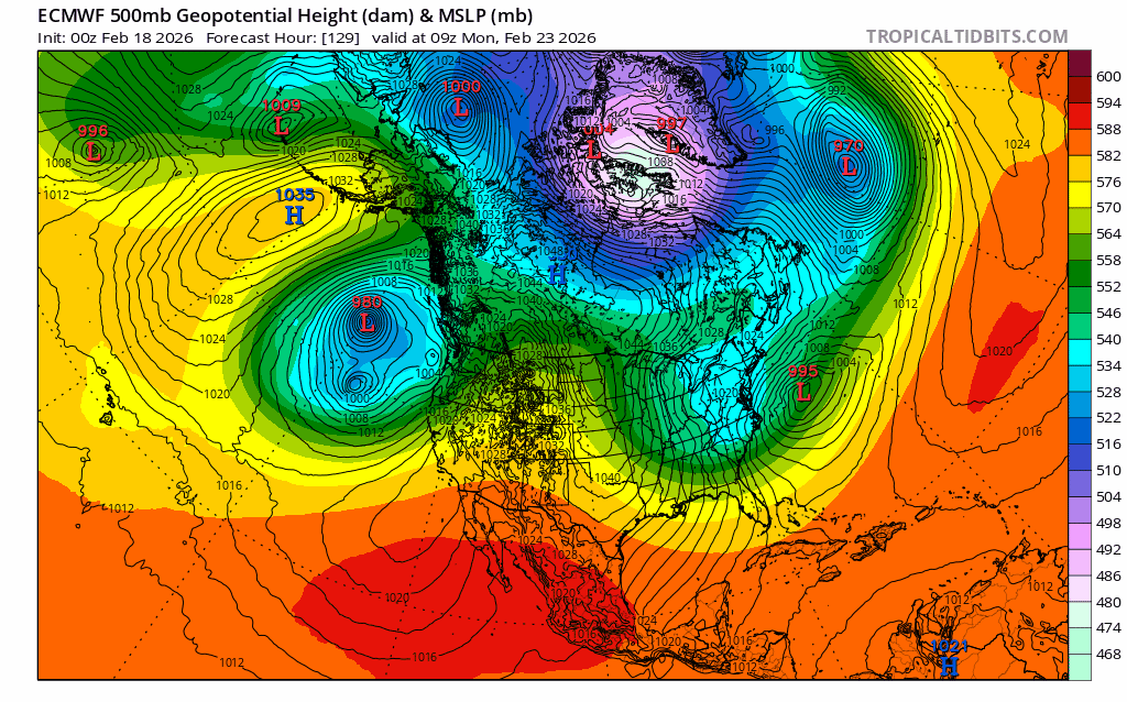
Yes, this year sure has bucked the typical norther trends. last weeks "event" came slightly north and we went from nothing to fringed. Seasonal tendency does not show up on tellies or factor into algorithms, so while the last 24 hrs hasn't been trends we want to see, as Mag suggested, you gotta look at 500's first before figuring out how the lower levels are gonna look. That said, there is a lot of sorting to do. Was really hoping the earlier phase was going to work out, but Friday's deal is screwin the snow pooch and not giving time/spacing to dive in, keeping the flow more progressive. -
If it makes you feel better it's not lake effect. Just a spring like frontal passage. The next line looks fun in a summer way lol
-
Its following the GEFS MJO. Its in phase 6 there. Should pick up on phase 7 2nd week of March.
-

Late February/Early March 2026 Mid-Long Range
SomeguyfromTakomaPark replied to WxUSAF's topic in Mid Atlantic
That's looking like the Euro AI precip distribution wise except displaced a tad north, also get's that 6 inch line way back into VA. I'd love to see the members for this. -

2025-2026 ENSO
Stormchaserchuck1 replied to 40/70 Benchmark's topic in Weather Forecasting and Discussion
SOI has been lagging the last few years 25-26 RONI Nina: the monthly SOI never went >+10 until October '25 24-25 RONI Nina: the monthly SOI never went >+10 at all 23-24 Strong Nino: SOI was Neutral until May 2023, when the El Nino began. Feb-March-April 2023 average SOI was +2.7/month. -

Wednesday Feb 18 Mixed event. NOPE …ain’t happenin’
dendrite replied to HoarfrostHubb's topic in New England
More name title changes from Dave than inches of snow from this. -
(002).thumb.png.6e3d9d46bca5fe41aab7a74871dd8af8.png)
Central PA Winter 25/26 Discussion and Obs
ChescoWx replied to MAG5035's topic in Upstate New York/Pennsylvania
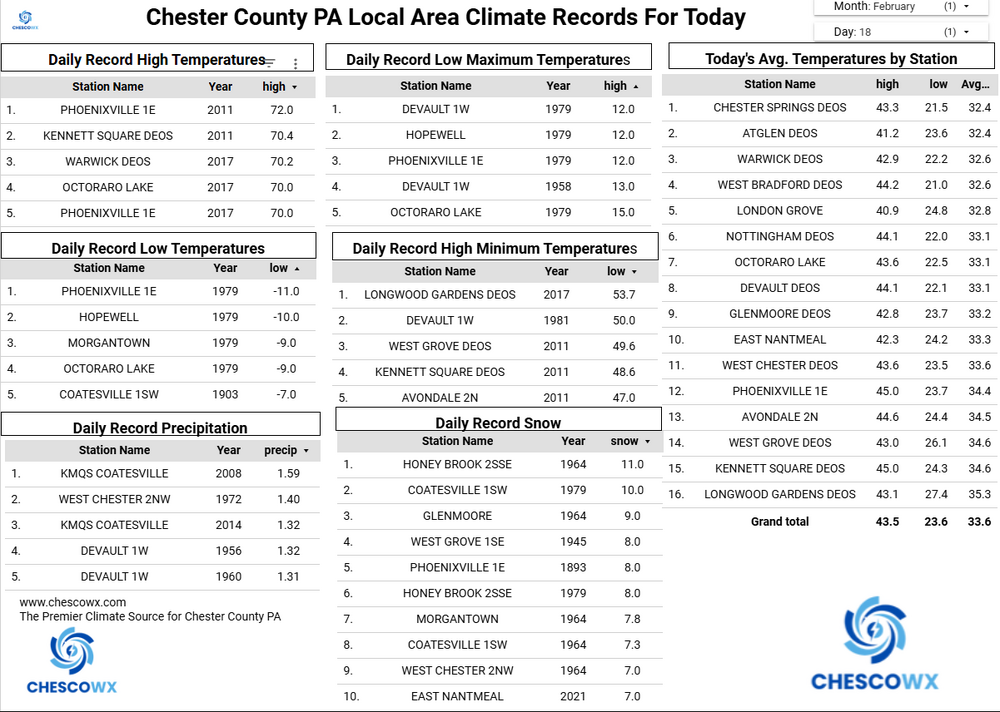
Fog should slowly diminish later this morning. We should see some light rain across especially for spots north of the PA Turnpike this afternoon. Rain amounts look light with most spots less than 0.15". Today’s temperatures will be in the low 40's just about average for the date. Rain chances to ramp up again tomorrow night and especially Friday with more significant rain expected. Snow chances look to increase by Sunday but way too early to nail down specifics.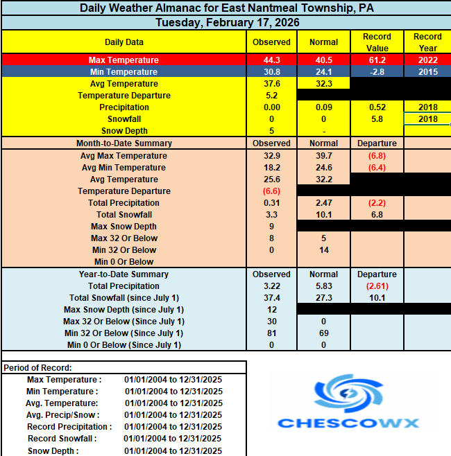
-
E PA/NJ/DE Winter 2025-26 Obs/Discussion
ChescoWx replied to LVblizzard's topic in Philadelphia Region
Fog should slowly diminish later this morning. We should see some light rain across especially for spots north of the PA Turnpike this afternoon. Rain amounts look light with most spots less than 0.15". Today’s temperatures will be in the low 40's just about average for the date. Rain chances to ramp up again tomorrow night and especially Friday with more significant rain expected. Snow chances look to increase by Sunday but way too early to nail down specifics.
-
2025-2026 ENSO
Stormchaserchuck1 replied to 40/70 Benchmark's topic in Weather Forecasting and Discussion
Still no signs of pattern change in March on long range ensemble models -

2025-2026 ENSO
40/70 Benchmark replied to 40/70 Benchmark's topic in Weather Forecasting and Discussion
Like I said last week, the dip may have just been rushed...we are seeing some trending towards that. -

“Cory’s in NYC! Let’s HECS!” Feb. 22-24 Disco
Typhoon Tip replied to TheSnowman's topic in New England
-
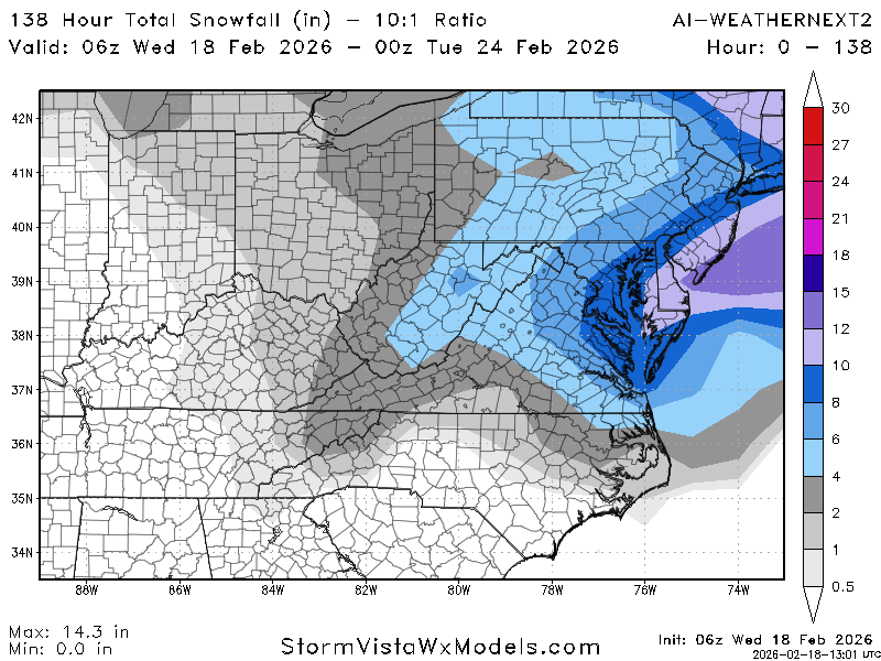
6Z SV AI Weathernext2: 8” DC
-
Is we back? February discussion thread
40/70 Benchmark replied to mahk_webstah's topic in New England
Yea, I mentioned folks have up on that reversal too quickly...maybe it won't technically get there, but it will be close. -
84 hr. NAM is even more fun to look at - 12Z should be fun too
-
where's my projected 35" over the next 7 days????
-
“Cory’s in NYC! Let’s HECS!” Feb. 22-24 Disco
40/70 Benchmark replied to TheSnowman's topic in New England
Yes, the "fast flow" explanation is a bit too reductive IMHO. -

“Cory’s in NYC! Let’s HECS!” Feb. 22-24 Disco
Go Kart Mozart replied to TheSnowman's topic in New England
06z euro improvement seems tied to that douchy feature over New Brunswick. Let's see that injection continue to withdrawitserlf to the NE.
-
The best thing I can say this morning is this threat is still 4 days away. Anything can happen in 4 days. Yesterday morning I said don't plan tailgate parties until Saturday. That applies again today. One big question to me has always been. Will the main action be tucked into the coast or too far offshore?? Yesterday, the Euro couldn't find the storm because it was half way to Bermuda before it really cranked. Things are a little better this morning but the GEFS is way out there. The benchmark for a big hit west of 95 is usually an east longitudinal alignment with Norfolk. South or even southwest is a different ballgame. Eastern folks can do somewhat better a little offshore, but this is too much for most. (Unless it changes) Always trying to be positive, I'm happy that my 7 model blend this morning is 2.1 inches.
-
There has been about three hours of sun in the past five days.
-
Yeah, quite a bit closer than 0Z... with GFS going the opposite direction. There will probably be more run that tries to pull everybody in
-
Well whatever is causing these systems to be so progressive, It's irritating...They need to wind up sooner. Turn the corner.
-
“Cory’s in NYC! Let’s HECS!” Feb. 22-24 Disco
40/70 Benchmark replied to TheSnowman's topic in New England
Yes, exactly. -
“Cory’s in NYC! Let’s HECS!” Feb. 22-24 Disco
40/70 Benchmark replied to TheSnowman's topic in New England
Irony being @MJO812has been citing the decaying block as the reason we are going to get a big storm all week -
0.25” of rain overnight. HRRR is selling a few inches of snow here this afternoon. Going to be a nowcast type of day.
-
Not such a bad look on the Eps Sunday at 1pm. And it is a mean.
.thumb.png.536873bd5ecb0c4ecdf166ce17d4991c.png)


.thumb.png.4150b06c63a21f61052e47a612bf1818.png)


.png.0096cd53dcf41af4e5a8c4c59e3e28f8.png)