All Activity
- Past hour
-

2026-2027 El Nino
40/70 Benchmark replied to Stormchaserchuck1's topic in Weather Forecasting and Discussion
Yea, subtle shift with the "angle of the dangle" of that vortex, and whole new pattern. It was not only the -WPO ridge shifting east, but the NAO blocking dissipated, so we got the dreaded elongation of the "football" shaped PV. -
Back to back lows of 24 and 22; chilly for sure.
-
-

-
-
Luckily it’s largely fake.
-
27 this morning, yesterday's low was 28. Hopefully last freeze until the fall.
-
IT'S GOING TO RAIN ALL DAY! WEEKEND RUINED!1!111!!
-
Let’s get these freezing morning the F outta here! And don’t let the door hit em in the ass.
-
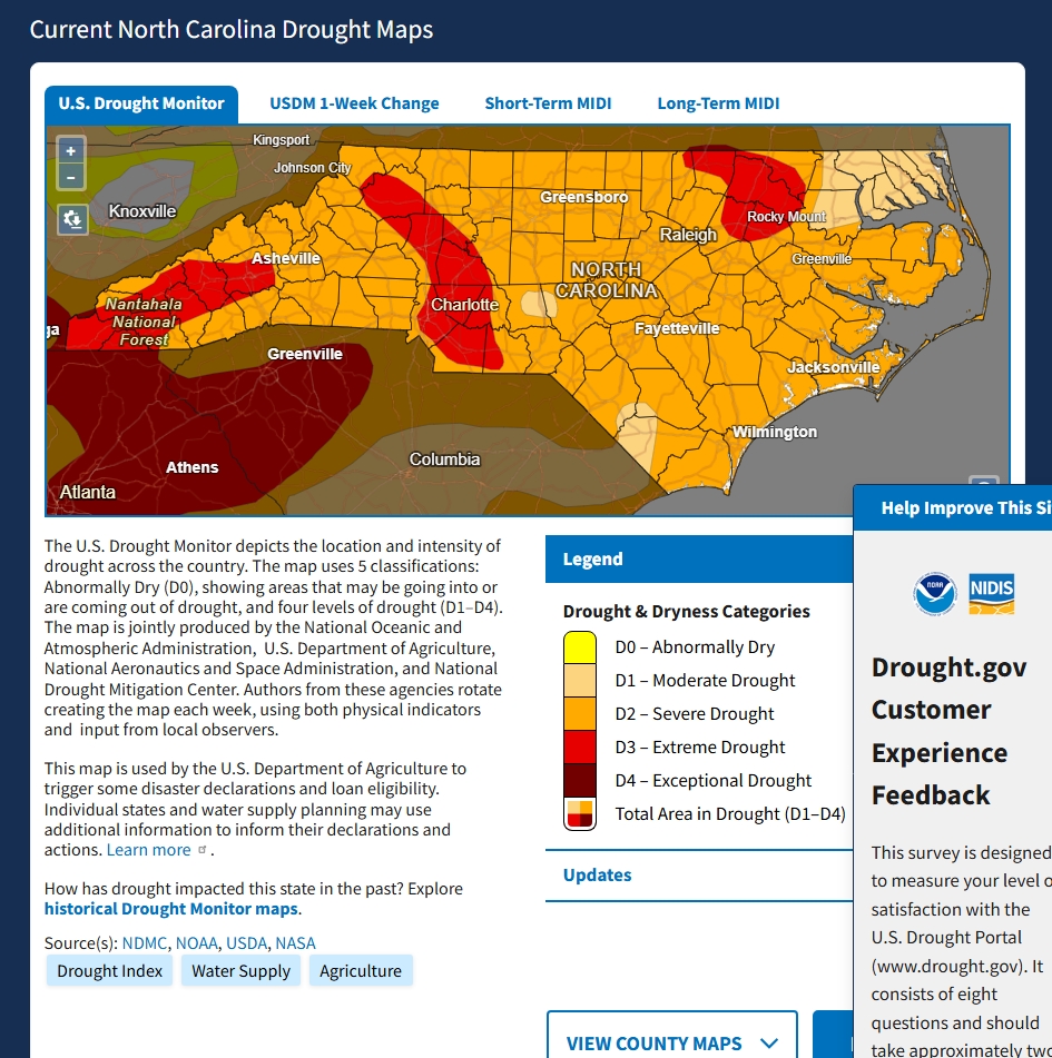
I’ll enjoy the nice weather coming up but dear lord we need buckets of rain. If you believe the climate models, seems like Nino kicks in precip-wise in August?
-
Low was 27⁰ here with lots of frost.
-

2026-2027 El Nino
bluewave replied to Stormchaserchuck1's topic in Weather Forecasting and Discussion
We just don’t want a repeat of the west based -WPO like we had in March which could allow too much of a +EPO Aleutian low position with El Niño forcing. Climatologist49 @climatologist49.bsky.social Follow As impressive as the southwestern U.S. mega-ridge was in March, the eastern Siberia mega-ridge was even more anomalous! -
Low of 18° at KMVY.. about 24° here Thats should about wrap up the last gasp of winter
-
31 with windshield scraping frost. Colder than yesterday here.
-
(002).thumb.png.6e3d9d46bca5fe41aab7a74871dd8af8.png)
Central PA Spring 2026 Discussion/Obs Thread
ChescoWx replied to Voyager's topic in Upstate New York/Pennsylvania
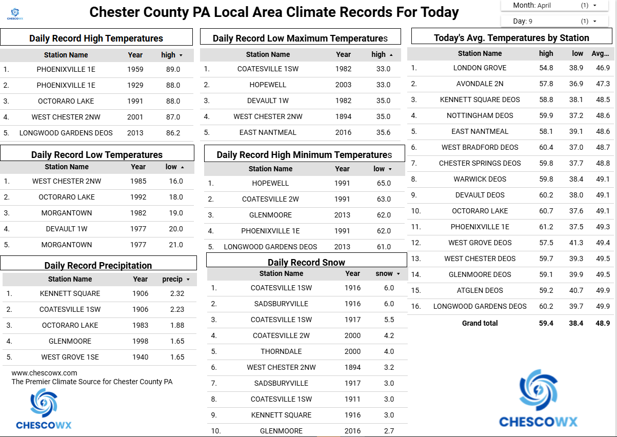
Another widespread freeze this morning across the area with our lowest Chesco climate station the 24.7 at the Warwick DEOS. We remain well below normal today with highs in the middle 50’s, but a nice warming trend kicks in starting tomorrow and we get very warm with low 80's possible by next Tuesday and Wednesday! We could use a little rain but nothing in sight over the next week.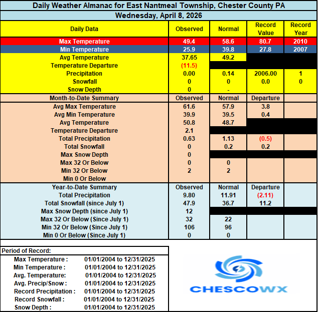
-
E PA/NJ/DE Spring 2026 Obs/Discussion
ChescoWx replied to PhiEaglesfan712's topic in Philadelphia Region
Another widespread freeze this morning across the area with our lowest Chesco climate station the 24.7 at the Warwick DEOS. We remain well below normal today with highs in the middle 50’s, but a nice warming trend kicks in starting tomorrow and we get very warm with low 80's possible by next Tuesday and Wednesday! We could use a little rain but nothing in sight over the next week.
-
2026-2027 El Nino
40/70 Benchmark replied to Stormchaserchuck1's topic in Weather Forecasting and Discussion
It will also be interesting to see how the burgeoning warm ENSO interacts with the apparent north Pacific phase change, as we have clearly shifted to more of a -WPO base-state. If El Nino does grow as powerful as some suspect, it may be more like a 1982-1983 type of deal, where as the north Pacific was a bit more favorable. -
I was at ULowell for that. I lived kind of far off campus and had to walk to classes. The flooding meant I had to make a big, time consuming detour
-
Frosty morning here. Might be the last until next fall
- Today
-
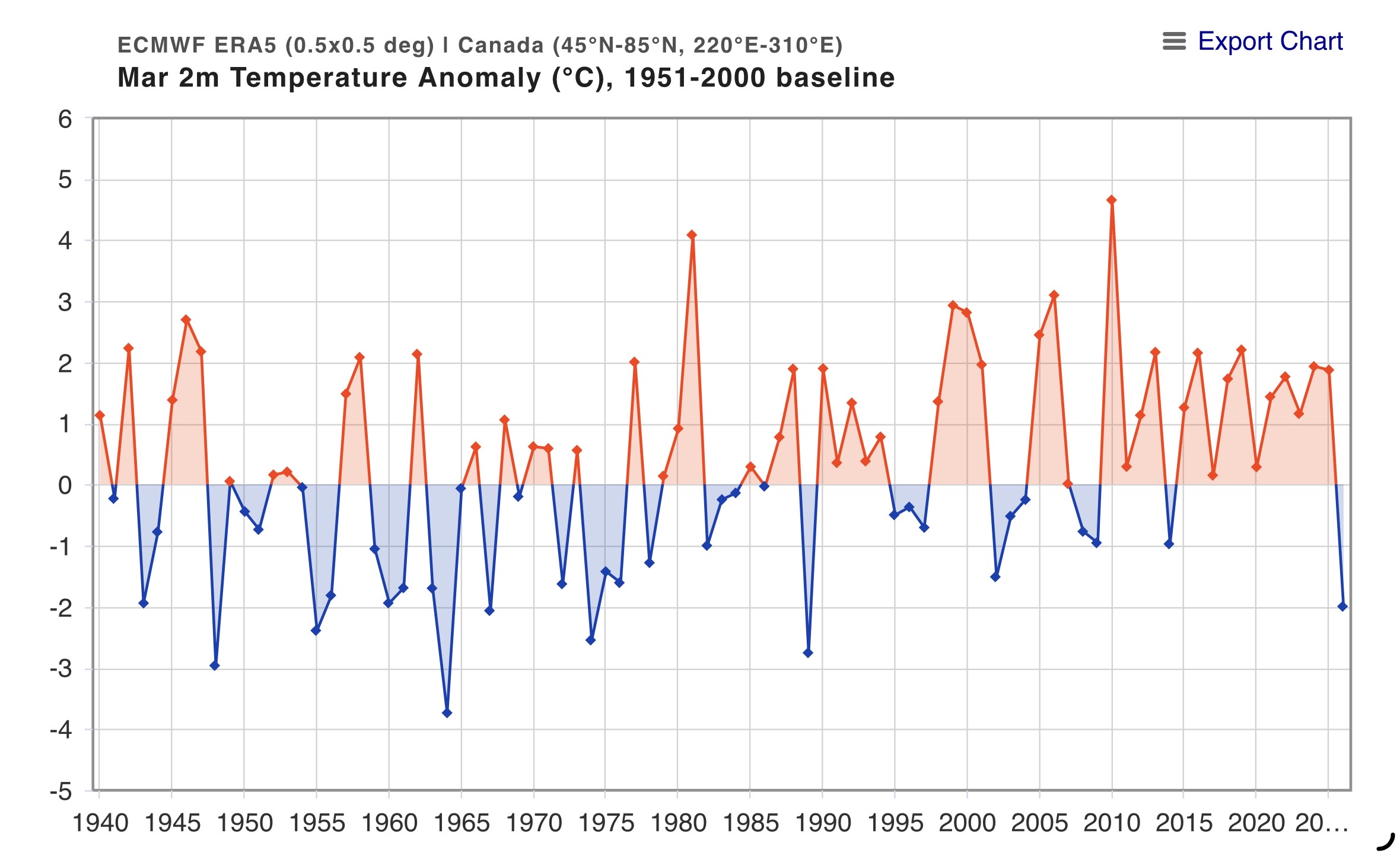
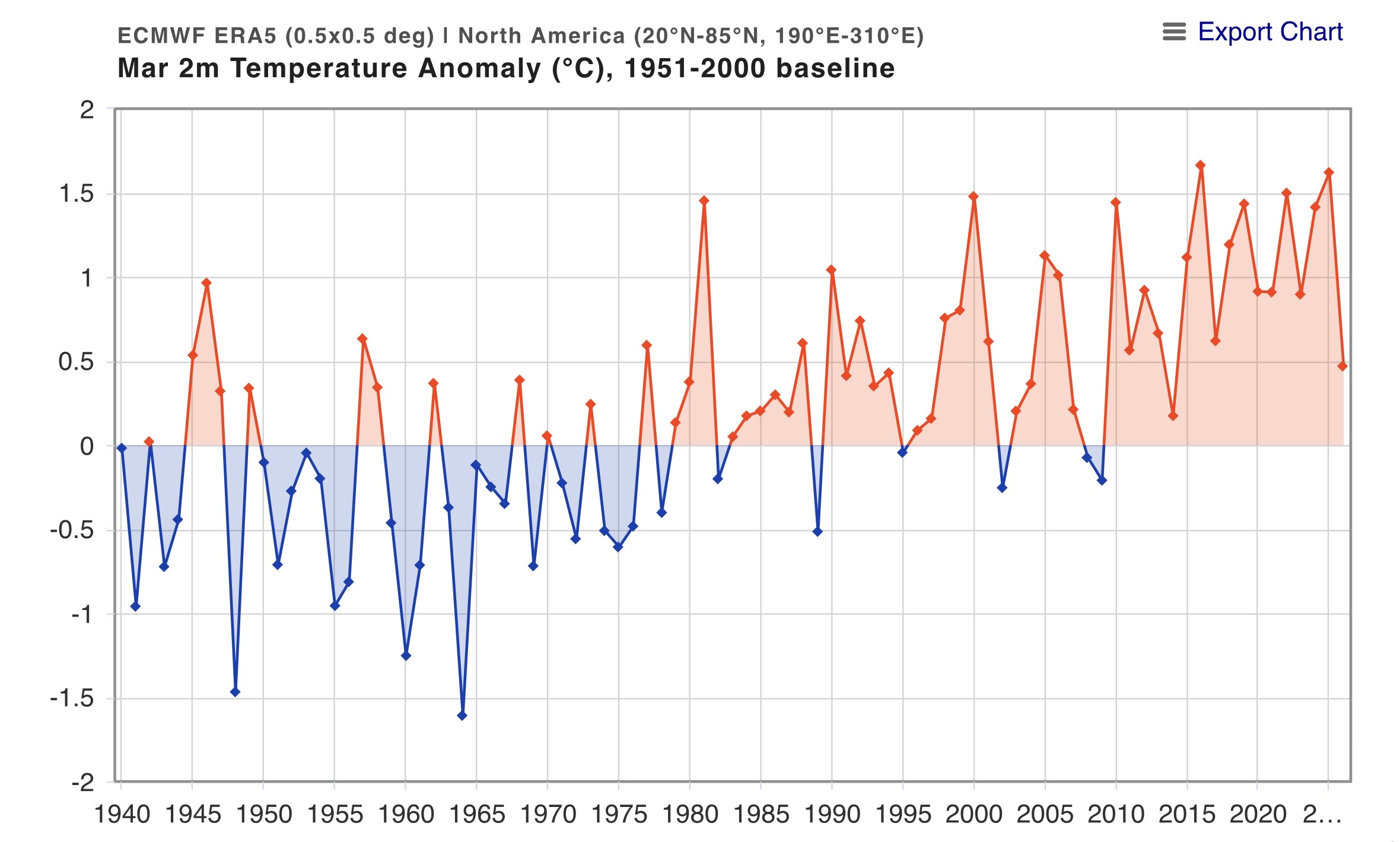
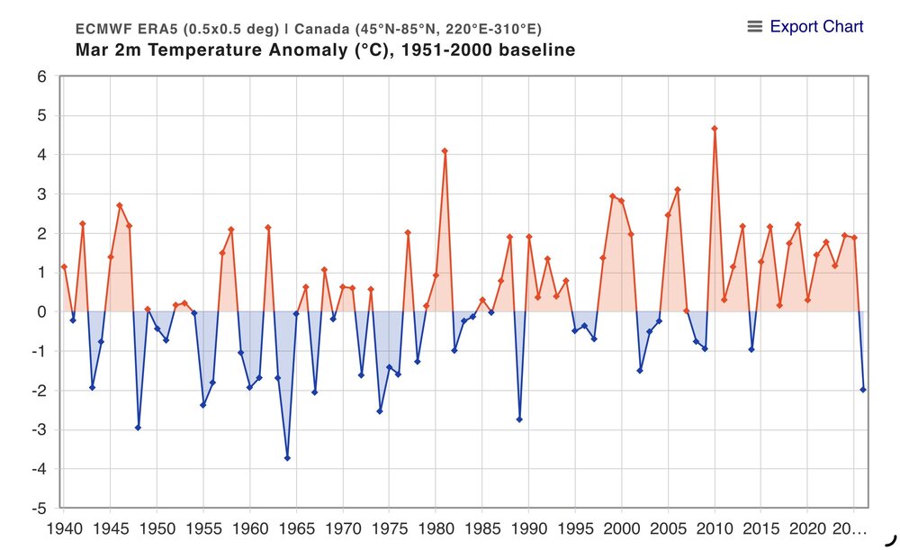
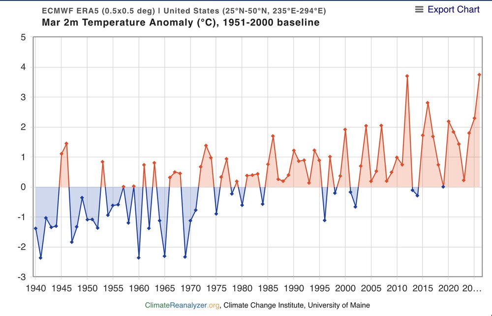
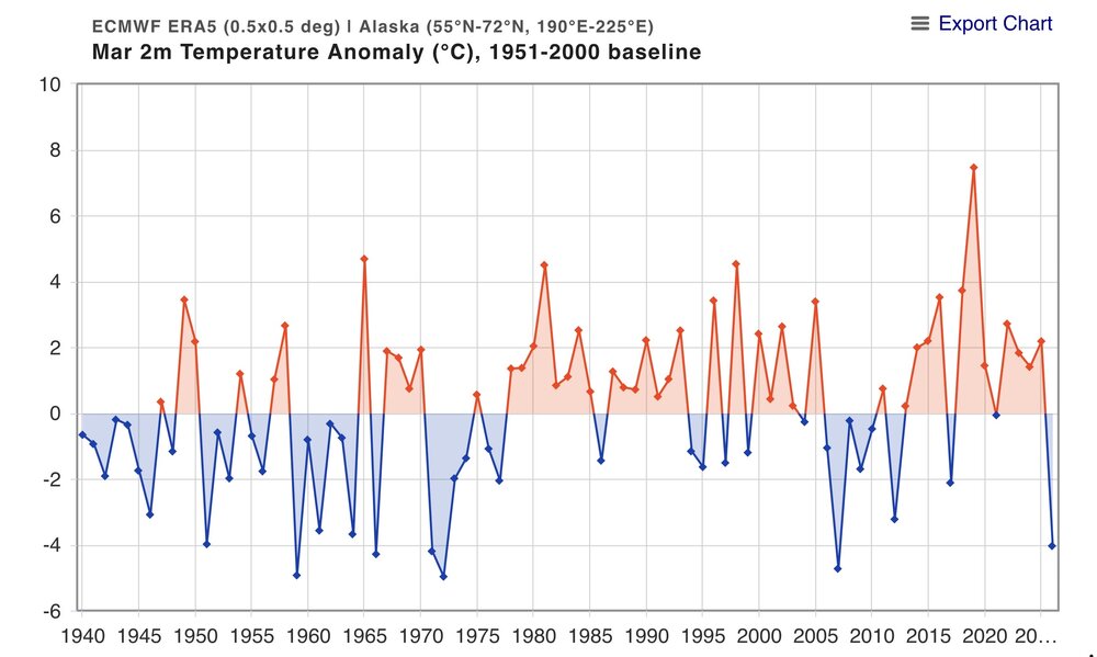
While Canada had its coldest March since the late 1980s and Alaska back to the 2000s, the warmest CONUS March allowed North America to finish warmer than average.

-
I don't understand why folks can't grasp the fact that a mere "30% chance of showers" in the p&c will trigger the rain icon in the graphics. It's really not complicated at all.
-
2026-2027 El Nino
bluewave replied to Stormchaserchuck1's topic in Weather Forecasting and Discussion
Even during a weak La Niña this winter, the ridges were the strongest on record compared to past weak La Niña events like 1995-1996 with -WPO /SW ridge and Greenland blocking. If we get a strong to very strong El Niño, then it could potentially lead to a stronger 500mb El Nino ridge to the north and weaker Aleutian Low and Southeast trough like 2023-2024. The exact location where the 500 mb ridge maxes out will be important. Remember how all the models underestimated the ridge and overestimated the trough. They incorrectly had the classic strong El Niño stock composite with deep troughs. Perhaps if the El Niño passes a certain threshold, then at least the Aleutian Low and maybe the Southeast Trough can be stronger. But we may have to wait until the winter to observe the exact response since these seasonal 500mb forecasts usually are missing some key elements. Even though several models had a -WPO and Southwest ridge for last winter, none came close to how strong it was. Climatologist49 @climatologist49.bsky.social Follow For the Dec-Mar period, the southwestern ridge reigns supreme. An area over +5 standard deviations from the 1991-2020 normal. The eastern Siberia anomaly was *only* +4.5 standard deviations. -
another beautiful day on tap to be followed by a garden variety spring soaker best climo
-
Dropped down to 22. Currently 28
- 263 replies
-
- 1
-

-
- april showers bring may..
- rain
- (and 2 more)
-
Just below freezing here this am at 31.2, good bit warmer than yesterday's 27.2.