All Activity
- Past hour
-
always good to question our own measurement techniques. This storm was difficult, especially with drifting. I guess if I could sign up for 9" of snow, and then 2" of sleet on top of that, I would, 100% of the time. Secondary did little for NE Jersey, except cause the dry slot. Seems to be an "incongruity" in easter Bergen County, with measurements up to 16"? While further west in Bergen county, snow measurements were more like 10"-12". I first thought that the changeover was delayed there, but then theorized that a heavier band must have come through, before the changeover?
-
 Pretty sure I read Vernon CT 21" in this forum a few pages back
 -

The “I bring the mojo” Jan 30-Feb 1 potential winter storm
Clemsonlady replied to lilj4425's topic in Southeastern States
How does the upstate of SC look for this next one… gotta travel from Clemson to Charlotte area this weekend. . -
Gimme
-
Compared to the 00z Ensemble Mean, the 06z was a tad more closer to the coast.
-
Its west of the last run. And it’s not that much more east than eps mean.
-
-

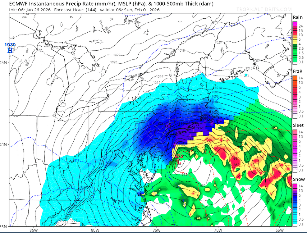
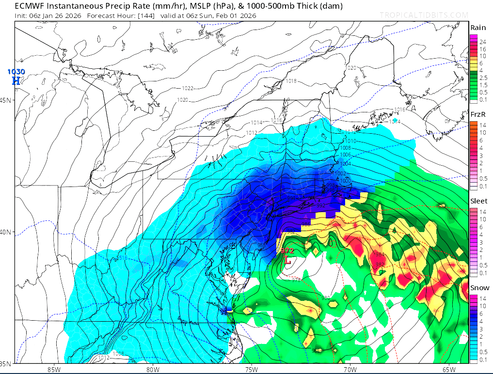
Possible coastal storm centered on Feb 1 2026.
Typhoon Tip replied to Typhoon Tip's topic in New England
Okay so ... some key synoptic facets. 1 the western end of the modulating SPV 2 the interloping S/Stream injecting underneath 3 the heights over the SW Atl Basin are psuedo relaxed; evidenced by larger gap in isohypses, with balanced geostrophic wind only 30 kts, and heights lower the 582 or Miami ( as proxy). What I'm not showing in this image is the western ridge/+PNA response, because it is yet to happen. In two more days after this 81 hour Euro solution from 06z, the western ridge surges polarward.. right along a very complementary longitude. This helps to trigger the N/stream's descent in latitude through the lakes - that western fragmentation of the SPV. As this happen.. the 3 is not as shearing/destructively interfering as it would be if the heights were higher and the balanced geos. wind was strong...such that the whole structure is allowed to conserve more of it's amplitude as the phasing commences, sex happens... and it all gives birth to a storm.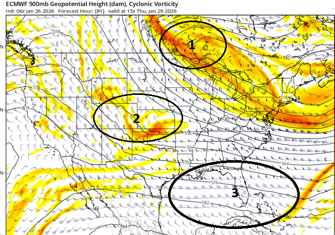
-
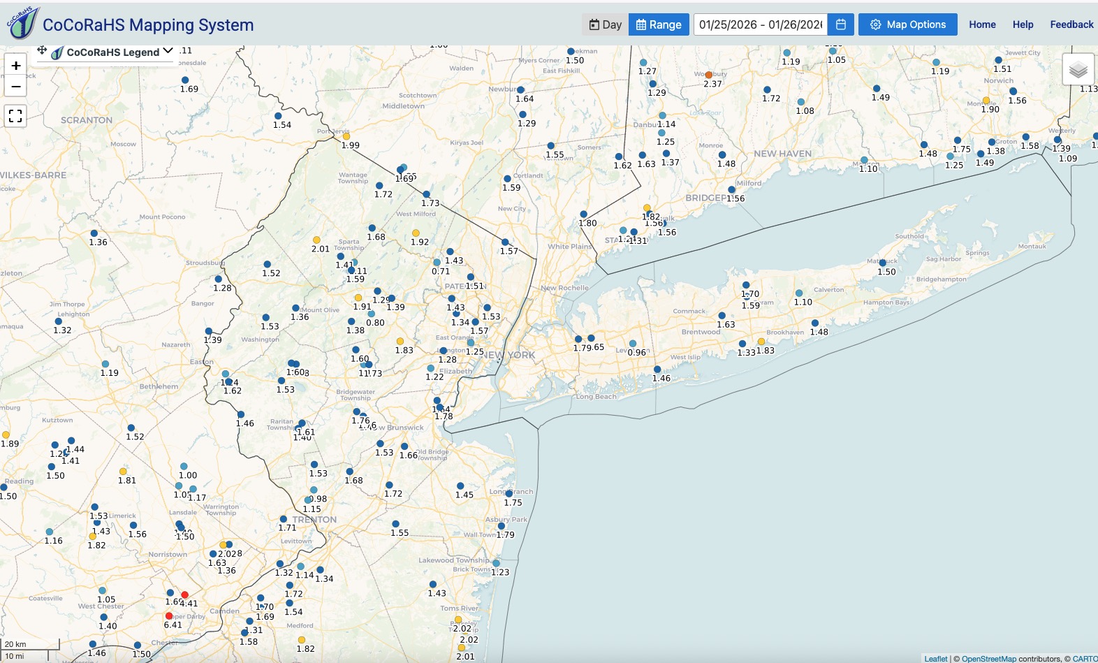
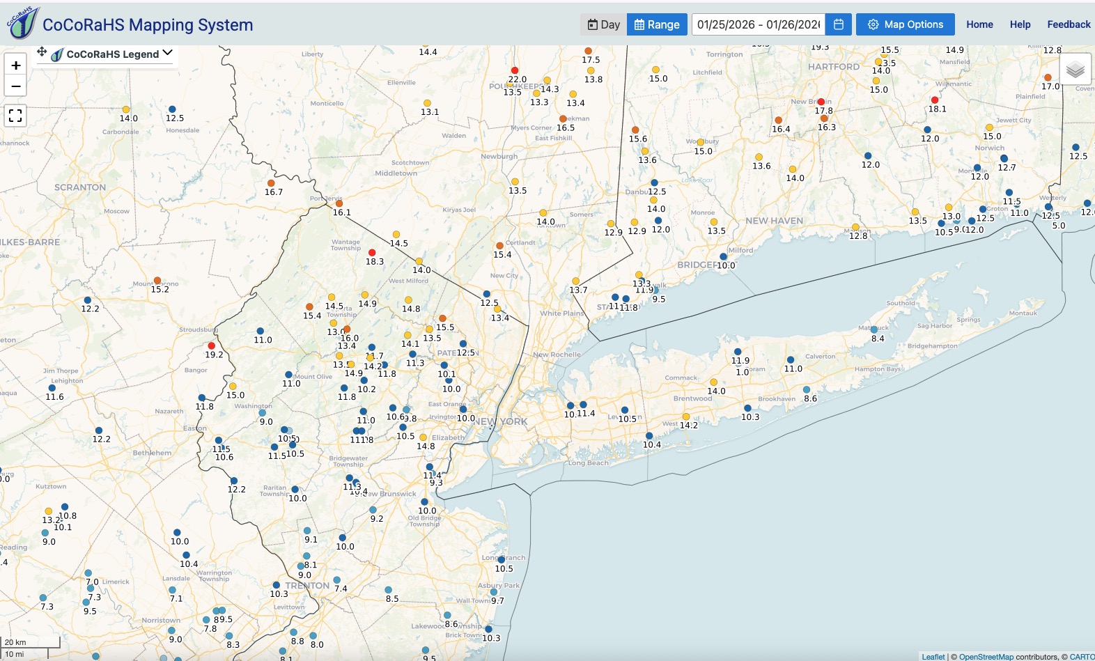
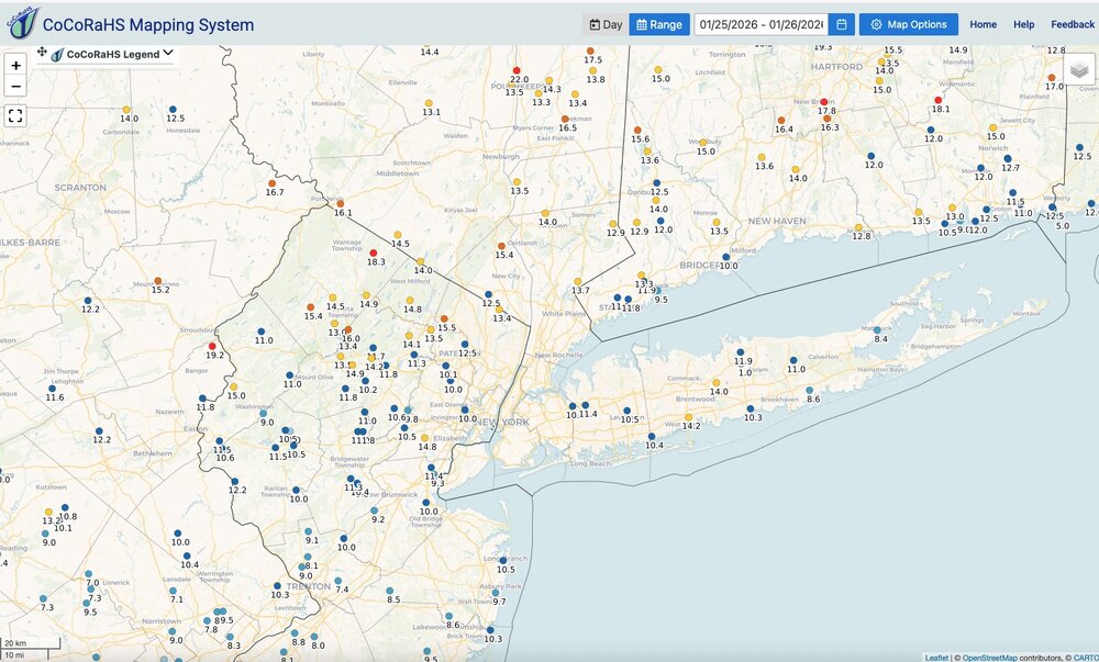
Storm total snowfall and QPF: Click to enlarge maps. QPF clearly over performed even the wettest guidance, in some cases by 1/2" or more depending on the location and model of choice. The models ticking up the QPF as we got closer to the event start time was clearly on the right track though. Quick spot checks on ratios and nothing to write home about when averaged out over the storm duration....roughly 8:1 to 12:1 along the I78-I80 corridor and east across the city and LI. Just did a quick spot check. I'd have to give a nod to the higher QPF totals for getting storm total snowfall to near or over the high end ranges of the forecast. If they had been more or less as modeled in the 1 to 1.25" and taking the actual ratios into consideration storm total snowfall would have been closer to the lower end of the forecast ranges. Just my 2 cents.

-
I believe it would be captured at this point and the strong 500mb ULL south of us would be doing its magic
-

Pittsburgh/Western PA WINTER ‘25/‘26
TimB replied to Burghblizz's topic in Upstate New York/Pennsylvania
Record is 7 in Feb 1899. We had 6 in Jan 1936 and a bunch of years with 4 (most recently the 1994 one that includes our all timer of -22). -
One for the Weather Porn folder.
-
I've never had to dig out with a pick ax before, but the colossal amount of sleet demanded it. Hard to believe that Wisp recorded 19" and about 10 miles south, and at about the same elevation, I recorded a third of that. Began the day at 27.9 and it's now 7 degrees. Regardless of accumulation, it's about as deep of winter as I've seen around here.
-
I'm honestly quite intrigued about the late week potential. It has a legitimate upside (even B-word) potential for this area.
-

Central PA Winter 25/26 Discussion and Obs
canderson replied to MAG5035's topic in Upstate New York/Pennsylvania
I thiiiiiink this storm tied for Harrisburg’s 12th largest ever. -
It could be about twice what we had yesterday. It was also on the Euro AI and GFS. And of course then there's a storm to celebrate the anniversary of the great 1978 storm. You wouldn't want to miss that one. WX/PT
-
Yup. It was before this past storm took center stage. The big ones often make a comeback.
-
 This snow is dry powder if there is such a thing.
 -
Storm total snowfall and QPF: Click to enlarge maps. QPF clearly over performed even the wettest guidance, in some cases by 1/2" or more depending on the location and model of choice. The models ticking up the QPF as we got closer to the event start time was clearly on the right track though. Quick spot checks on ratios and nothing to write home about when averaged out over the storm duration....roughly 8:1 to 12:1 along the I78-I80 corridor and east across the city and LI. Just did a quick spot check. I'd have to give a nod to the higher QPF totals for getting storm total snowfall to near or over the high end ranges of the forecast. If they had been more or less as modeled in the 1 to 1.25" and taking the actual ratios into consideration storm total snowfall would have been closer to the lower end of the forecast ranges. Just my 2 cents.


-
I don’t have a dedicated snowboard spot where I live for consistent measurements like the official airport OBS and COOP sites. I took 50 measurements in a nearby open baseball dirt field and hour ago away from any obstructions which averaged at 9”. The field had completely lost any snowpack from the last event. Closer to the fence line the average was 10-12” with a maximum peak of 15” right behind the long fence. In closer to the houses here my average is also 10-12”. So I can understand the variability in the official NWS OBS from urban to rural locations and between the public, CO-OP, and other readings. Prior to this weekend I measured 13” from the collection of smaller events with marginal temperatures at times.
-

The “I bring the mojo” Jan 30-Feb 1 potential winter storm
StantonParkHoya replied to lilj4425's topic in Southeastern States
Technically, Currituck, NC is the mid-point along the eastern seaboard, but we're still here, so you can be too -

Winter 2025-26 Medium/Long Range Discussion
buckeye replied to michsnowfreak's topic in Lakes/Ohio Valley
I’m cool with big snows…. But not cool with dry tundra weather with no end in sight, can always hope to reel in this weekends upcoming HECS…. That’s going to be a monster for those guys -
He always does that when he bust very badly.
-
 Oh absolutely. Just pointing it out more for the science behind the scenes aspect. So this isn't anything to knock down or play down the storm or intensities ordeal but it just goes to show how extremely difficult it is to get a storm where you have a consistent ratio. Now, at the end of the day, total wise it may not truly matter (except when talking about very high end stuff)...so it was a factor in why we didn't see widespread 20-30" type stuff but for those forecasting it's something that really needs to be given thought when making a forecast. We all won on this one
 -
If I'm nitpicking...that WeatherNext model is a bit too offshore. I know it shows digital blue over us - but it is a good ways out to seat on that plot. We'll see how this week of model tracking pans out!


.thumb.JPG.418e8a9a2902ae687ec35ff4bc0e038e.JPG)