All Activity
- Past hour
-
CT RI and to about PYM rains. Now that I dropped fert we
-

Occasional Thoughts on Climate Change
TheClimateChanger replied to donsutherland1's topic in Climate Change
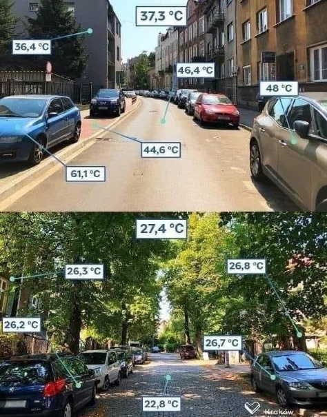
That's a stupid graphic measuring surface temperature, not near surface air temperatures. Certainly, being shaded can cool the air temperature as well [not to that extent], but surface air temperatures are supposed to be observed in a location free from shading and obstructions. -

Hurricane Erin: 100 MPH - 954 mb - NNW @ 13
GaWx replied to BarryStantonGBP's topic in Tropical Headquarters
Hurricane Erin Intermediate Advisory Number 37A NWS National Hurricane Center Miami FL AL052025 200 PM EDT Wed Aug 20 2025 SUMMARY OF 200 PM EDT...1800 UTC...INFORMATION ---------------------------------------------- LOCATION...30.6N 73.6W ABOUT 530 MI...855 KM W OF BERMUDA ABOUT 335 MI...540 KM SSE OF CAPE HATTERAS NORTH CAROLINA MAXIMUM SUSTAINED WINDS...110 MPH...175 KM/H PRESENT MOVEMENT...N OR 360 DEGREES AT 13 MPH...20 KM/H MINIMUM CENTRAL PRESSURE...943 MB...27.85 INCHES Some strengthening is expected during the next day or so, and Erin could become a major hurricane again by tonight. Weakening is likely to begin by Friday, but Erin is forecast to remain a hurricane into the weekend. Erin is a large hurricane. Hurricane-force winds extend outward up to 105 miles (165 km) from the center and tropical-storm-force winds extend outward up to 265 miles (425 km). -

Hurricane Erin: 100 MPH - 954 mb - NNW @ 13
NJwx85 replied to BarryStantonGBP's topic in Tropical Headquarters
Thanks -
0.31” so far. Meh
-
Xmas Eve?
-
Thanks, I figured it was something like that. It is pretty amazing how that happens that it can even out for the high temps. Something like this I picture see posted often in numerous ways showing the difference, in a city setting, how having trees lowers temps everywhere from the air to the ground we walk on (and has been done around the world proving it works). Wouldn't this be an example of UHI during the day? Or, would we say the temps on the lower picture are not accurate for the air since it is under a canopy of trees? So the lower picture is like Central Park temps which people in my forum argue about every day of the week and the top picture is actually the accurate one for temps? Here is where this pic was from https://symsoil.medium.com/trees-climate-change-and-community-878280498546 I see this movement talked about often though for cities and it would be nice if adopted by many more.
-
My temp forecast for early next week is 70/52 for Tuesday. Rocking some early October feel in August is hard to beat.
-

Hurricane Erin: 100 MPH - 954 mb - NNW @ 13
wthrmn654 replied to BarryStantonGBP's topic in Tropical Headquarters
We now have a fairly decent eye again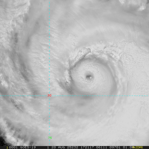
-
That’s a rough August day.
-
Yea some much needed slow rain today. Ground need the moisture here badly.
-
Hurricane Erin: 100 MPH - 954 mb - NNW @ 13
wthrmn654 replied to BarryStantonGBP's topic in Tropical Headquarters
I'm part of the NWSChat stream now and i essentially just asked them about the impacts especially coastal flooding as this storm track keeps being shifted north/ west. If that will increase areas not under costal flood watch, eastern long island for example, and other risks. I await to see if I get an answer. -

E PA/NJ/DE Summer 2025 Obs/Discussion
Ralph Wiggum replied to Hurricane Agnes's topic in Philadelphia Region
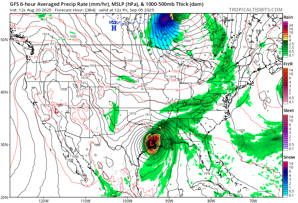
Early September Southern Canada Blizzard with a strong hurricane pounding Texas at the same time. Sign me up...only 384 hrs out.
-
.09 at the woodyard.
-
Bodies stiffening

-
-
Hurricane Erin: 100 MPH - 954 mb - NNW @ 13
GaWx replied to BarryStantonGBP's topic in Tropical Headquarters
You need to delete the portion after the “?”. -
This is beautiful—look at the radar detail!!
-

Hurricane Erin: 100 MPH - 954 mb - NNW @ 13
WxWatcher007 replied to BarryStantonGBP's topic in Tropical Headquarters
-
 PRE is so far north this is a disaster
 -
 Nice view with Erin coming up https://cdn.star.nesdis.noaa.gov/GOES19/ABI/SECTOR/eus/02/GOES19-EUS-02-1000x1000.gif
 -
Hurricane Erin: 100 MPH - 954 mb - NNW @ 13
NJwx85 replied to BarryStantonGBP's topic in Tropical Headquarters
https://twitter.com/accurayno/status/1958159185348091929?s=46&t=wnL9UkNay47lChNZhqU2Pw No idea why this won’t embed. I changed from x to twitter. -
Getting a pretty good downpour here. Only one rumble of thunder so far.
-
Force field engaged